
ORLANDO, Fla. – Central Florida on Monday woke up to another very cold morning, marking the second straight day with temperatures in the 20s across much of the area.
This kind of cold is rare in the Orlando area and last occurred during the historic December 2010 cold outbreak.
[VIDEO BELOW: Let it (fake) snow! Dad plays hero in Florida]
MONDAY
A strong Nor’easter lifting away from the Mid-Atlantic continues to influence our weather.
[FLA. FREEZE GUIDE: Everything you need to know]
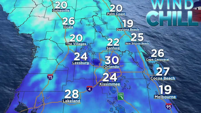
Lows early Monday fell into the 20s across inland areas, with upper 20s to low 30s closer to the coast. Clear skies and light winds allowed widespread frost and ice to develop.
An Extreme Cold Warning and Freeze Warning remain in effect through late morning before temperatures warm into the mid-50s.
[VIDEO BELOW: Freezing temps displace UCF residents]
TUESDAY
A slow warmup begins Tuesday as high pressure builds in.
Highs climb into the 60s Tuesday, with near normal temperatures returning by Wednesday.
Patchy frost may still be possible early Tuesday and Wednesday, especially across interior locations, with lows in the 30s.
[VIDEO BELOW: Thermal camera captures crazy cold in Florida]
WHAT’S NEXT?
Another cold front is expected later this week, bringing increased rain chances at 30-40% midweek and the potential for another brief shot of colder air late Thursday into Friday. It does not appear that the next cold blast will be as intense as the current one.
Stay warm — and safe!
Daily Forecast
The News 6 Weather team ensures you’re always on top of the day’s weather.
Copyright 2026 by WKMG ClickOrlando – All rights reserved.