
Temps to fall to freezing levels for most of Florida’s Gulf Coast by Tuesday morning
>> I’M SO OVER THIS COLD. >> SAME HERE. WE WENT THROUGH QUITE THE QUITE THE WEEKEND AROUND HERE. SO WHAT I WANTED TO DO IS REDUCE SOME OF THE COLD TEMPERATURE RECORDS THAT WERE BROKEN OVER THIS PAST WEEKEND. AND WE HAD 3 RECORD LOMAX TEMPERATURES. SO THIS IS LIKE EXPRESSING THE THE COLD AS WE’VE EVER BEEN DURING THE AFTERNOON HOURS. SO IN THE CITY OF FORT MYERS ON FEBRUARY. 1ST, THE HIGH WAS ONLY 51 DEGREES THAT SIMPLY SMASHED THE PREVIOUS RECORD OF 57 FROM 1979 IN THE CITY OF NAPLES ON FEBRUARY. 1ST, WE ONLY IT 51 DEGREES AND THAT REALLY SMASHED THE OLD RECORD OF 64 DEGREES. THAT WAS SET BACK IN 1980, GORDA, THOUGH. THAT’S WHERE THE RECORDS WERE SMASHED IN HARDER THAN CHRISTIE. SOTO’S RAP SKILLS RECORD COLD MAX TEMPERATURE ON FEBRUARY. FIRST WAS 50 DEGREES WHICH BROKE THE PREVIOUS RECORD FOR THE LOW TEMPERATURE OF 56 DEGREES SET BACK IN 1979, YOU MIGHT BE SURPRISED TO HEAR, THOUGH, THAT IT IS LIKE ALL THE COLD WEATHER. THERE ARE ONLY 2 RECORD LOWS SET OVER THE COURSE OF THE PAST FEW DAYS. THE FIRST ONE HAPPENED IN GORDA WHEN THE CITY’S OBSERVATION SITE DROPPED TO 29 DEGREES AND BROKE THE PREVIOUS RECORD BY A HUGE STRETCH THERE. THAT WAS 35 BACK IN 1936. AND THEN THIS MORNING, GORDA. IT ONCE AGAIN DROP BELOW FREEZING, BROKE THE OLD RECORD THAT HAD STOOD SINCE 1980, OF 33 DEGREES. WOW, ARE WELL, WE’RE NOT DONE WITH HIGH NEAR RECORD TERRITORY TOMORROW, AT LEAST IN THE CITY OF FORT MYERS IS OUR OUR GRAPHICS. SO THE FORECAST LOW RIGHT NOW IN THE CITY 35. AND THAT IS THOUGH NOT BREAKING OR TYING. THE RECORD IS AWFULLY CLOSE TO CURRENT RECORD ON THE BOOKS RIGHT NOW FOR TOMORROW MORNING IN THE CITY OF FORT MYERS IS 33. AND IT’S A REALLY OLD RECORD. GOES ALL THE WAY BACK TO THE YOUR 1917. SO COLD WEATHER IS VERY MUCH UP STILL IN CHARGE OF OUR FORECAST, EVEN THOUGH REALLY IS AN ALL TOO BAD OUTDOORS RIGHT NOW. ONCE THE SUN GOES DOWN, THE OF COURSE WE’RE GONNA COOL OFF PRETTY EFFICIENTLY TONIGHT. WE STILL HAVE A WIND THAT’S PRIMARILY FROM THE NORTH. SO AS WE GET TOWARD EARLY TOMORROW AROUND THE SUNRISE HOUR, THAT’S WHERE YET AGAIN, WE ANTICIPATE TEMPERATURES TO FALL EITHER TO OR JUST BELOW THE FREEZING POINT AND BUCKINGHAM LEHIGH ACRES AND GATEWAY. AND THEN JUST A TOUCH ABOVE THE FREEZING POINT AND NEIGHBORHOODS LIKE NORTH FORT MYERS AND FORT MYERS. REMEMBER, ALL OF INLAND LEE IS UNDER A FREEZE WARNING ALL THE WAY THROUGH 9 O’CLOCK IN THE MORNING TOMORROW. SO I KNOW IT’S A HASSLE TO COVER UP TROPICAL PLANTS AND COLD WEATHER SENSITIVE PLANTS. BUT DO IT ONE MORE TIME TONIGHT. AND THEN WE’RE FINE FOR THE REST OF THE WEEK BECAUSE THE NIGHTTIME LOWS WILL BE WARMER FOR THE REST OF THE WEEK AFTER TONIGHT THAT FREEZE WARNING, BY THE WAY, EXTENDS ACROSS ALL OF INLAND COLLIER. THAT’S WHERE TEMPERATURES TONIGHT ARE FORECAST TO FALL BACK INTO THE MID AND UPPER 30’S WITH UPPER 30’S AND LOW 40’S IN CLOSER AREAS TULSA TO THE BEACHES, INLAND AREAS, OF COURSE, OF COLDER YET JUST AROUND THE FREEZING POINT AND POINTS WEST OF LAKE OKEECHOBEE, WHICH IS WHY THAT FREEZE WARNING HAS BEEN EXTENDED TO ALL OF GLAZE AND ALL OF HENDRY COUNTY AND THEN ACROSS THE CHARLOTTE AND DESOTO, THE FREEZE WARNINGS TECHNICALLY ONLY INCLUDE INLAND CHARLOTTE TO DESOTO AND SARASOTA, BUT WE’RE GOING TO BE AWFULLY CLOSE TO THE FREEZING POINT IN AREAS LIKE PORT CHARLOTTE AND ROTUNDA, COMMUNITIES EVEN CLOSE TO THE WATER LIKE ANGLE WOULD FORECAST TO DROP ALL THE WAY DOWN TO 36 DEGREES OVERNIGHT TONIGHT AND VERY EARLY TOMORROW MORNING. SO ONE MORE VERY, VERY COLD MORNING FOR US. AND THEN WE START ATTEMPT TO TURN THE TIDE ONCE WE GET TOWARD THE AFTERNOON, HIGH TEMPERATURES WILL BE A LITTLE WARMER TOMORROW AS COMPARED TO TODAY, EVENTUALLY GETTING BACK INTO THE UPPER 60’S AND WEDNESDAY WILL BE EVEN WARMER WITH HIGHS BACK IN THE LOW 70’S. UNFORTUNATELY, IF YOU’RE NOT A BIG FAN OF THE COLDER WEATHER, THERE IS YET ANOTHER COLD FRONT ON THE WAY AS OF RIGHT NOW, THIS ONE’S GOING TO ARRIVE VERY EARLY ON THURSDAY. WE COULD CERTAINLY USE THE RAIN. THIS ONE’S GOING TO ATTEMPT TO BRING TO OUR AREA. BUT AS IT MOVES AWAY FROM US ONCE AGAIN, IT’S GOING TO PULL DOWN ON THE TEMPERATURES. NOW IN TERMS OF THE RAIN RIGHT NOW, THE RAIN TIMING AS THE WHITE IS COVERAGE OF ANY SHOWERS WITH THIS FRONT MOVING THROUGH DURING THE FIRST FEW HOURS OF THE DAY ON THURSDAY, SOME TOUCH BASE AT SOME POINT LATER THIS WEEK AND WE’LL SEE IF THE TIMING HOLDS UP HERE. BUT AS OF RIGHT NOW, THE BEST CHANCE OF ANY RAIN FALLING FROM THIS IN DOWN FRONT ON THURSDAYS, REALLY, REALLY FOCUSED IN DURING THE FIRST FEW HOURS OF THE DAY AFTER THE LUNCH HOUR, THE FRONT PULLS AWAY FROM US AND THE RAIN MOVES AWAY. SO WITH THAT IN MIND, THEN OUR FOCUS. WE JUST TURN BACK TO THE DROP IN TEMPERATURE. SO THE WAY THE 7 DAY FORECAST GOES AGAIN, HE’S TONIGHT IS THE COLDEST OF THE REST OF THE WEEK COVER UP THE PLANS. ONE MORE TIME TONIGHT. AND THEN YOU SHOULD BE OK FOR THE REST OF THE WEEK BECAUSE FOR THE REST OF THE WEEK, WE DON’T SEE AN OPPORTUNITY FOR NIGHTTIME, LOW TEMPERATURES TO DROP EITHER TO OR BELOW THE FREEZING POINT. HOWEVER, THAT FRONT ON THURSDAY DOES PUSH DOWN ON THE TEMPERATURES AS OVERNIGHT THURSDAY INTO EARLY FRIDAY. ONCE AGAIN, MANY COMMUNITIES WILL FALL BACK INTO THE LOW 40’S AND THEN THE EXTENDED WEATHER PATTERN CONTINUES THE STREAK OF BELOW AVERAGE TEMPERATURES AS WE GO
Temps to fall to freezing levels for most of Florida’s Gulf Coast by Tuesday morning

Updated: 5:01 PM EST Feb 2, 2026
After record-breaking cold temperatures Monday morning, we are in store for another chilly day. Temperatures will struggle to make it out of the 50s Monday afternoon. That puts us about 15 degrees colder than normal. The mercury will crash down to the 30s again Monday night. Most of the Gulf Coast will be under a freeze warning Monday night. Remember to protect the four P’s: people, pets, plants and pipes. A light breeze will make it feel like the 30s and 20s Tuesday morning.Gradual warming will begin to take place midweek before another cold front moves across the state Thursday. This front will not be as cold as this weekend’s front; however, lows will once again drop to the 40s. Follow, like and subscribe to Gulf Coast News on social media to share your tips and be part of the conversation with Southwest Florida’s most experienced, trusted weather team.However you watch or scroll, we’re committed to delivering accurate, timely forecasts you can rely on, wherever you are.Follow on social media: Facebook | Instagram | YouTube | TikTok | Threads | Bluesky | Nextdoor | XLive Interactive RadarTrack conditions in real time with the Gulf Coast Live Radar.Watch Gulf Coast WeatherFind the latest weather forecast videos, streaming live or on demand, on TV and online.Stream on the GoDownload the free Gulf Coast News app to watch on your phone or tablet.Your Gulf Coast Storm TeamChief Meteorologist Allyson RaeMeteorologist Caroline CastoraMeteorologist Jim DickeyMeteorologist Jason DunningMeteorologist Lauren HopeMeteorologist Raphael TavernierMeteorologist Rob DunsMeteorologist Sara Blue DOWNLOAD the free Gulf Coast News app for your latest breaking news and weather alerts. And check out the Very Local Gulf Coast app to stream news, entertainment and original programming on your TV.
FORT MYERS, Fla. —
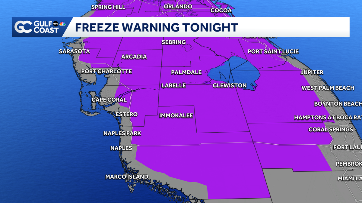
After record-breaking cold temperatures Monday morning, we are in store for another chilly day.
Temperatures will struggle to make it out of the 50s Monday afternoon. That puts us about 15 degrees colder than normal. The mercury will crash down to the 30s again Monday night.

Most of the Gulf Coast will be under a freeze warning Monday night. Remember to protect the four P’s: people, pets, plants and pipes.
A light breeze will make it feel like the 30s and 20s Tuesday morning.

Gradual warming will begin to take place midweek before another cold front moves across the state Thursday. This front will not be as cold as this weekend’s front; however, lows will once again drop to the 40s.
Follow, like and subscribe to Gulf Coast News on social media to share your tips and be part of the conversation with Southwest Florida’s most experienced, trusted weather team.
However you watch or scroll, we’re committed to delivering accurate, timely forecasts you can rely on, wherever you are.
Follow on social media: Facebook | Instagram | YouTube | TikTok | Threads | Bluesky | Nextdoor | X
Live Interactive Radar
Watch Gulf Coast Weather
Stream on the Go
Your Gulf Coast Storm Team
DOWNLOAD the free Gulf Coast News app for your latest breaking news and weather alerts. And check out the Very Local Gulf Coast app to stream news, entertainment and original programming on your TV.