
Dangerous cold expected overnight in Central Florida and into Tuesday before a warm-up
LET’S GET BACK TO WARM WEATHER SOON. I’VE GOT EVERYTHING. I’VE GOT BOTH FOR BOTH OF YOU. WARM AND COLD. LET’S GO STRAIGHT TO THE WEATHER GRAPHICS BECAUSE WE’VE GOT ONE MORE COLD NIGHT AHEAD. SO SANIKA JESSE, YOU’RE GOING TO BE HAPPY. BUT THOSE WHO DON’T LIKE THE COLD, WE’VE GOT TO WARM UP ON THE WAY. THIS WEEK, COLD WEATHER ADVISORIES IN EFFECT FOR THE OVERNIGHT HOURS UNTIL 9:00 TOMORROW MORNING. BECAUSE ONCE AGAIN, ANOTHER ROUND OF DANGEROUS COLD. WE’RE LOOKING AT TEMPERATURES AS LOW AS THE UPPER 20S. AND THAT IS MOSTLY GOING TO BE FOR OUR FRIENDS AND NEIGHBORS UP TO THE NORTH AND WEST OF ORLANDO. FOR EXAMPLE, A LOW OF 27 EXPECTED TOMORROW MORNING IN OCALA. WE’RE LOOKING AT A LOW OF 32 IN LEESBURG, 32 IN SANFORD AND 33 IN ORLANDO. THIS MORNING AND YESTERDAY MORNING WE COMPLETELY SHATTERED OUR RECORD LOWS. I DON’T THINK THAT’S GOING TO BE THE CASE BUT WE COULD TIE THE RECORD LOW IN SANFORD TOMORROW MORNING IN MELBOURNE. WE MIGHT BE ABLE TO CRUSH YOUR RECORD LOW, BUT WE’RE NOT EXPECTING ANY WIDESPREAD RECORD LOWS THOUGH. AS YOU WAKE UP ON TUESDAY MORNING. THEN TUESDAY AFTERNOON TEMPERATURES DO IMPROVE, WILL CLIMB INTO THE LOW 60S WITH LOTS OF SUNSHINE VERY SIMILAR TO WHAT WE SAW TODAY. SO MILD AIR IS ON THE WAY LIVE. LOOK OUTSIDE RIGHT NOW YOU CAN SEE BEAUTIFUL CLEAR SKIES, BUT DON’T LET THAT SUNSHINE FOOL YOU. YOU’LL STILL NEED A JACKET IF YOU’RE HEADING OUT THIS AFTERNOON OR THIS EVENING. WE’RE CURRENTLY AT 55 IN SANFORD, 53 IN THE CITY. BEAUTIFUL. AND GOOD AFTERNOON, DAYTONA BEACH AT 53 DEGREES. CLEAR SKIES, DRY CONDITIONS. IF YOU HAVE PLANS OUT THIS EVENING, YOU WON’T HAVE TO DEAL WITH ANY RAIN. BUT WE ARE LOOKING AT IMPACT WEATHER ONCE AGAIN OVERNIGHT INTO TOMORROW MORNING BECAUSE AFTER THE SUN SETS, THE TEMPERATURES WILL RAPIDLY FALL AND AGAIN WE’LL BE DOWN INTO THE UPPER 20S AND 30S ACROSS CENTRAL FLORIDA. BUT AS I MENTIONED, A WARM UP IS ON THE WAY ON WEDNESDAY. WE ARE LOOKING AT MILD CONDITIONS WITH TEMPERATURES IN THE LOW 70S AHEAD OF OUR NEXT COLD FRONT. THAT FRONT NOT EXPECTED TO ARRIVE UNTIL THURSDAY, AND THAT’S GOING TO BRING US SOME RAIN SHOWERS. NOW BEHIND THAT NEXT COLD FRONT, IT WILL BE CHILLY ONCE AGAIN, BUT FOR ONE, IT’S NOT GOING TO BE AS COLD AS WHAT WE SAW THIS WEEKEND, AND THE COLD WON’T BE PROLONGED EITHER. SO COME FRIDAY MORNING, EXPECT LOWS IN THE 30S 30 IN OCALA AND 37 IN ORLANDO, 33 IN DELAND. THIS IS FRIDAY MORNING NOW, BUT QUICKLY THOSE TEMPERATURES DO MODERATE FOR THE WEEKEND. LOOK AT THIS. WE ARE LOOKING AT PICTURE PERFECT CONDITIONS THIS UPCOMING WEEKEND. I WOULD SAY THIS UPCOMING WEEKEND FORECAST KIND OF IS A REDEMPTION FOR THE REALLY CRUMMY WEEKEND WE HAD LAST WEEK WITH THAT BRUTAL COLD. SO HERE’S A LOOK AT YOUR CENTRAL FLORIDA CERTIFIED MOST ACCURATE SEVEN DAY FORECAST IMPACT WEATHER FOR TOMORROW MORNING, WITH ONE MORE CHILLY NIGHT AHEAD, THEN WE’VE GOT PERFECT WINTER CONDITIONS ON WEDNESDAY. RAIN SHOWERS IN THE FORECAST THURSDAY, AND THEN AS WE HEAD INTO THE LATE WEEK, ONE COLD DAY AND THAT’S FRIDAY. BUT THEN LOOK AT THE WEEKEND INTO EARLY NEXT WEEK. A VERY NICE AND MILD STRETCH OF WEATHER WITH HIGHS IN THE LOW 70S. AGAIN, PERFECT WINTER WEATHER THIS UPCOMING WEEKEND. COMING UP IN THE NEXT HALF HOUR 4.47 I’LL SHOW YOU HOW MUCH RAIN WE COULD GET ON THURSDAY. GOT TO TEL
Dangerous cold expected overnight in Central Florida and into Tuesday before a warm-up

Updated: 5:33 PM EST Feb 2, 2026
One more night of freezing temperatures is expected across Central Florida as the region tries to thaw out from record lows. Monday night and into Tuesday could drop to as low as 27 degrees in some areas. Because of the dangerous cold, the First Warning Weather team is calling for Impact Weather on Tuesday morning. A cold weather advisory has been issued for most of Central FloridaNext warmupDays of freezing temps First Warning Weather Stay with WESH 2 online and on-air for the most accurate Central Florida weather forecast.RadarSevere Weather AlertsDownload the WESH 2 News app to get the most up-to-date weather alerts. The First Warning Weather team includes First Warning Chief Meteorologist Tony Mainolfi, Eric Burris, Marquise Meda and Cam Tran.What is Impact Weather?Impact Weather suggests weather conditions could be disruptive or a nuisance for travel and day-to-day activities.
ORLANDO, Fla. —
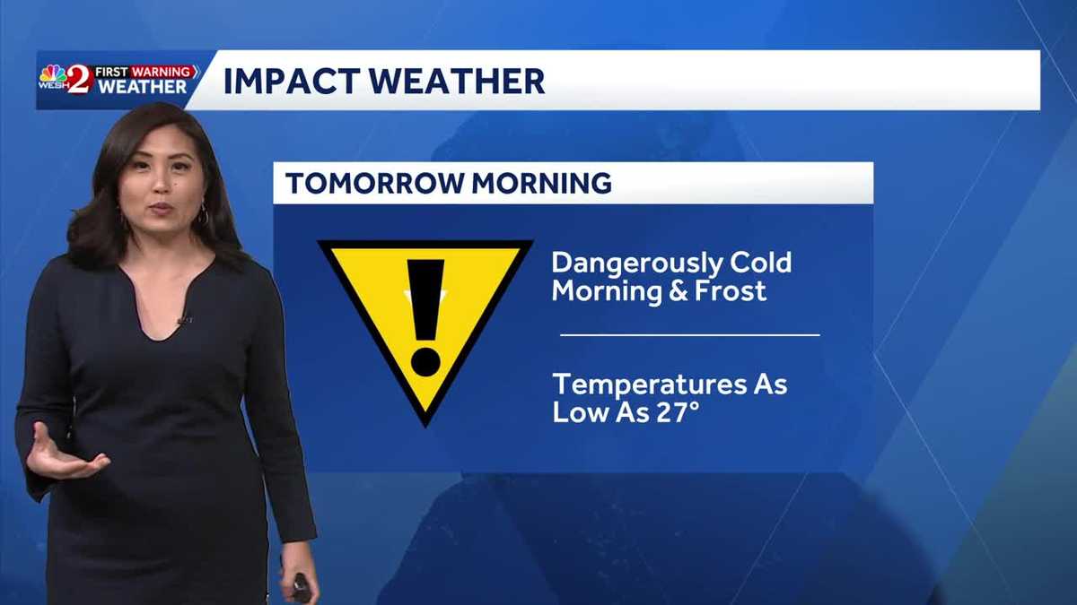
One more night of freezing temperatures is expected across Central Florida as the region tries to thaw out from record lows.
Monday night and into Tuesday could drop to as low as 27 degrees in some areas.

WESH 2 News
Monday night into Tuesday morning temps
Because of the dangerous cold, the First Warning Weather team is calling for Impact Weather on Tuesday morning.
This content is imported from Twitter.
You may be able to find the same content in another format, or you may be able to find more information, at their web site.
This content is imported from Twitter.
You may be able to find the same content in another format, or you may be able to find more information, at their web site.
A cold weather advisory has been issued for most of Central Florida

WESH 2 News
WX Feb. 2-3, 2026
Next warmup
This content is imported from Twitter.
You may be able to find the same content in another format, or you may be able to find more information, at their web site.
Days of freezing temps
First Warning Weather
Stay with WESH 2 online and on-air for the most accurate Central Florida weather forecast.
Download the WESH 2 News app to get the most up-to-date weather alerts.
The First Warning Weather team includes First Warning Chief Meteorologist Tony Mainolfi, Eric Burris, Marquise Meda and Cam Tran.
What is Impact Weather?
Impact Weather suggests weather conditions could be disruptive or a nuisance for travel and day-to-day activities.