
Tropical Storm Melissa has formed in the central Caribbean, and forecasters say South Florida should be keeping an eye on the long-range tracking models. It’s possible a hurricane may develop this week.
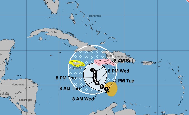
The system, which as of Tuesday was about 300 miles south of Haiti and moving west at 14 mph, had maximum sustained wind speeds of 50 mph, according to the National Hurricane Center.
Tropical-storm-force winds extend outward up to 115 miles from the center. Melissa is expected to strengthen into a hurricane by Saturday morning.
A hurricane watch has been issued for the southern peninsula of Haiti from the border with the Dominican Republic to Port-au-Prince. The government of Jamaica has issued a tropical storm watch for the island.
The current forecast track has the storm approaching the southwestern portion of Haiti and Jamaica later this week.
The track at that point becomes quite murky, said the hurricane center. Some models have the storm whisking north and east, out into the Atlantic, while others suggest it could meander farther west, toward Central American before veering north.
The farther west the storm travels the more likelihood it has of affecting Florida.
The so-called “spaghetti models,” which are computers that forecast the long-range track of a storm, show Tropical Storm Melissa turning sharply to the north and northeast while it is south of Cuba. Where that turn happens will determine the threat level to Florida.
If the storm turns in the central Caribbean, it will likely be a significant threat to Haiti, the Dominican Republic, or other islands — but keep Florida out of its direct path.
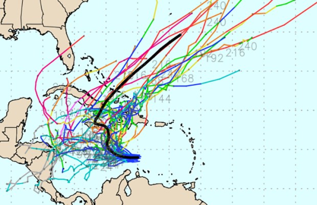 Forecast computer tracks, known as “spaghetti models,” show Tropical Storm Melissa making a turn north in the southern Caribbean, but show virtually no consensus as to where that turn will happen. (tropicaltidbits.com)
AccuWeather on Tuesday said “the U.S. concern for impacts will be in the Florida Peninsula, especially the lower portion of the Peninsula and the Keys.” AccuWeather also predicted that as the storm meanders in the Caribbean it could bring 12 to 30 inches of rain to portions of the Dominican Republic, Haiti, Jamaica and Cuba.
A steering force in the models is the subtropical jet stream, which has dipped into the Gulf.
The jet stream “seems content on parking itself there for the foreseeable future,” wrote WPLG-TV hurricane specialist Michael Lowry on his Eye on the Tropics blog. “Strong upper-level winds associated with this subtropical jet will continue to act as a staunch barrier against would-be threats, tearing apart anything trying to get close to the U.S. coastline.”
Computer models are split on how strong the storm will get. Most show Melissa strengthening into a hurricane by late in the week. Some models predict it could even become a major hurricane — Category 3 or higher.
“The storm would have to get to Jamaica or Mexico’s Yucatán Peninsula to be of concern to Florida as we see it now,” DaSilva said. “If the system remains weak and steers westward, it may continue on a path into Central America with no additional U.S. threat.”
Melissa is the 13th named storm of the 2025 Atlantic hurricane season. Four hurricanes have formed so far. Of the 13 named Atlantic storms, only Tropical Storm Chantal has made a U.S. landfall.
Hurricane season runs through Nov. 30.
Originally Published: October 20, 2025 at 7:47 AM EDT