
TALLAHASSEE, Fla. (WCTV) – Rain is likely across the Big Bend and South Georgia throughout Wednesday. Rain totals between a half inch and one inch are expected with today’s storm system. Mostly cloudy outside of any showers. An occasional rumble of thunder is possible, but no severe weather is expected.
The rain will be beneficial to the ongoing drought, but not enough to erase the severe lack of rainfall over the last several months.
Temperatures will remain mild today, reaching the low to mid-60s this afternoon with dew points in the 50s.
Small Craft Advisories are already in effect for Gulf waters through early Friday, as hazardous wind and wave conditions develop for boaters.
Advisory-level westerly winds may return Friday afternoon west of Apalachicola, spreading eastward Friday night. Conditions will begin to relax Saturday, leading to favorable boating by Sunday through the start of next week.
Cold Front Arrives with Wind
As the cold front passes through Wednesday evening, winds will pick up noticeably, shifting from southwesterly to northwesterly. Overnight lows will plunge to the low to mid-30s, with the southeastern Big Bend staying around 40 degrees.
Wind chills will feel like the mid to upper 20s for most areas due to gusty winds following the frontal passage.
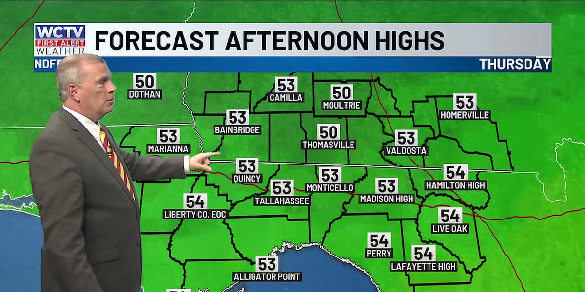
Cooler on Thursday
The cooldown intensifies Thursday as the region remains centered under a deep upper-level trough with brisk northwest winds aloft. Daytime highs will struggle to reach the low to mid-50s, and with surface winds around 15 mph and gusts near 20 mph, wind chills will hover in the 40s and low 50s throughout the day.
This will be the coldest day in your 7-day forecast.
Last freeze for a while?
With clear skies and light winds expected Thursday night, the coldest air will settle in. Temperatures are forecast to dip to the low 30s and upper 20s across the forecast area, with wind chills dropping to the low 20s.
Residents in sensitive areas should prepare now—protecting outdoor plants, bringing in pets, and ensuring adequate heating.
Weekend warm-up
Temperatures will begin rebounding Friday, with afternoon highs reaching the upper 50s to low 60s. The warming trend accelerates into the weekend with temperatures climbing into the mid and upper 60s by Saturday and Sunday.
By Monday and Tuesday next week, highs will reach the low 70s, a marked improvement over the cold snap. Overnight lows will warm into the 40s by the start of the work week. Rain chances remain zero after Wednesday’s frontal passage through at least Tuesday next week.
To stay updated on all the latest forecasts and weather, follow WCTV First Alert Weather on Facebook and X (Twitter).
Click here to see all the latest weather headlines and here to view the First Alert Radar. Receive push alerts and watch the latest forecast anytime on the free WCTV First Alert Weather app. Click here to download it now.
Interested in becoming a WCTV First Alert Weather Watcher? Click here to join the team!
Copyright 2026 WCTV. All rights reserved.