
Cold temps with wind chills in the 20s and 30s for South Florida
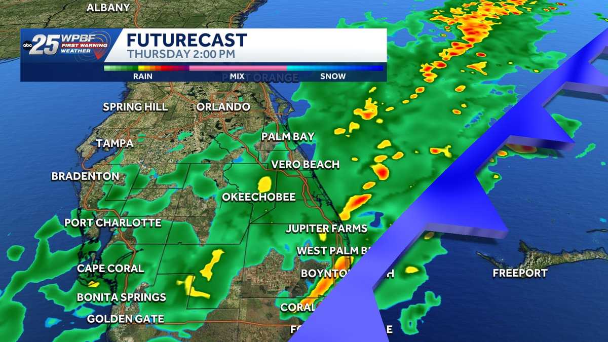
SANDRA. TIMING OUT THE SHOWERS FOR US AND THE LOW TEMPERATURES. UNFORTUNATELY. SANDRA. ALL RIGHT, WELL, WHAT’S GOING TO HAPPEN IS THE TREASURE COAST IS GOING TO SEE SOME RAINS FIRST, PROBABLY ABOUT 11:00 UNTIL ABOUT 1:00 THIS AFTERNOON. THEN THIS WAVE WILL GET THROUGH THE PALM BEACHES. NOT TERRIBLY INTENSE, BUT YOU ARE GOING TO SEE SOME RAINS TODAY, SO THAT’S DIFFERENT. IT’S ACTUALLY WELCOME BECAUSE WE’RE IN THE MIDST OF THE DRY SEASON AND EVERYWHERE IS IN A SEVERE DROUGHT FOR THE MOST PART, ESPECIALLY AROUND THE PALM BEACHES. SO WE DESPERATELY NEED SOME RAIN. WE’LL GET A LITTLE BIT TODAY. GOT A FEW DRIZZLE SHOWERS YESTERDAY. NOTHING THOUGH. WITH THAT SAID, ON FIRST WARNING RADAR IN OUR AREA OVER OUR VICINITY RIGHT NOW, COLD WEATHER ADVISORIES THOUGH IN ACTING LATER ON TONIGHT AND THEN WILL BE IN PLAY FOR TOMORROW MORNING. WE’RE GOING TO FEEL LIKE THE 30S AND 40S AGAIN. YOU CAN THANK THE RAIN AND THE COLD FRONT IT’S BRINGING IN ALONG WITH IT FOR ALL OF THAT. THAT WILL BE TOMORROW. BUT RIGHT NOW, NOT BAD. WE’VE GOT THE LOW 50S IN OKEECHOBEE, 45 IN VERO BEACH. IT’S 55 IN STUART, 59 IN WEST PALM, 52 IN DELRAY AND 55 IN BOYNTON BEACH. RIGHT NOW WE’RE IN ROUTE TO DAYTIME HIGHS TODAY HERE SOMEWHERE AT ABOUT 65 TO 70 ON THE TREASURE COAST WILL SEE IMPACT FOR 60% COVERAGE. SOME SHOWERS, MAYBE FOR ABOUT NOONTIME, IS WHEN IT PEAKS, PERHAPS EVEN EARLIER THAN THAT. 12 HOUR BEACH PALM BEACHES PLANNER GIVES US THE SHOWERS THIS AFTERNOON, AND IT LOOKS LIKE FROM 11 UNTIL THREE WE’LL HAVE SOME IMPACT WITH SOME RAIN. AGAIN, IT’S WITH THIS COLD FRONT THAT’S MOVING THROUGH, BRINGING IN THE RAINS. BY THE WAY THOUGH, AFTER THE COLD ON FRIDAY, WE’RE GOING TO SEE A NICER WEEKEND WITH THE 70S.
Cold temps with wind chills in the 20s and 30s for South Florida

Updated: 7:16 AM EST Feb 5, 2026
The WPBF 25 First Warning Weather team is tracking impact weather due to cold temperatures and wind chills across South Florida.A cold front is set to move through the area on Thursday. Scattered rainfall is possible.Winds will be breezy, and highs are expected in the 60s and a few low 70s.Temperatures are forecast to dive into the 30s and 40s Thursday night into Friday morning. Wind chills could be in the 20s and 30s.A cold weather advisory goes into effect Friday morning for the entire viewing area.It’ll be a cool Saturday morning with lows in the 40s and a wind chill.Stay with WPBF 25 on air and online for weather updates. Interactive radar: South Florida weather coverage from WPBF 25 NewsGet the latest weather updates with the WPBF 25 News app. You can download it here.
The WPBF 25 First Warning Weather team is tracking impact weather due to cold temperatures and wind chills across South Florida.
A cold front is set to move through the area on Thursday. Scattered rainfall is possible.
Winds will be breezy, and highs are expected in the 60s and a few low 70s.
Temperatures are forecast to dive into the 30s and 40s Thursday night into Friday morning. Wind chills could be in the 20s and 30s.
A cold weather advisory goes into effect Friday morning for the entire viewing area.


It’ll be a cool Saturday morning with lows in the 40s and a wind chill.
Stay with WPBF 25 on air and online for weather updates.
Interactive radar: South Florida weather coverage from WPBF 25 News
Get the latest weather updates with the WPBF 25 News app. You can download it here.