
Sunday morning is cold with an inland freeze and frost along the east beltway of 295.Jacksonville International Airport has fallen to freezing for the 21st time this season.Another day with full sunshine will mean temperatures warm quickly through the low and middle 60s.Onshore winds on Sunday will likely keep the coastal communities much colder than just a few miles inland.More clouds move overhead Sunday night and Monday, but we stay dry with temperatures closer to 70 Monday afternoon.Tuesday-Friday will be mild with dry weather and highs in the 70s.Drought continues to worsen, and the local wildfire risk continues as well.
JACKSONVILLE, Fla. — First Alert Weather 7-day forecast:
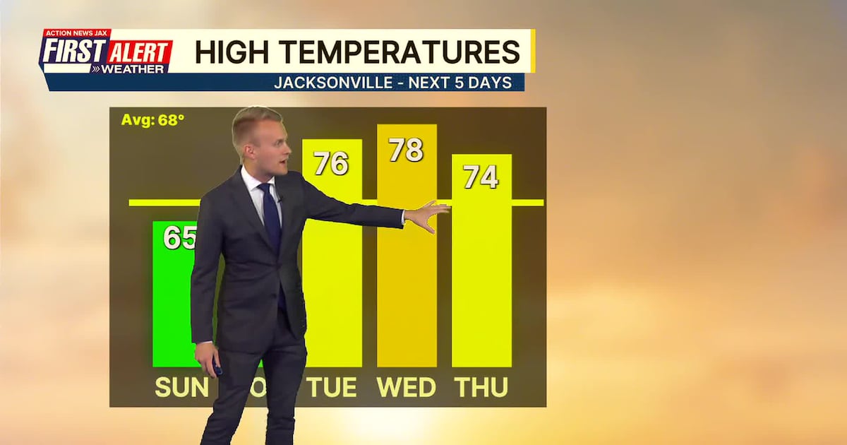
SUNDAY: AM Frost/Freeze, then sunny and nice. HIGH: 65
SUNDAY NIGHT: Partly cloudy and cool. LOW: 40
MONDAY: Mostly sunny to partly cloudy and pleasant. 40/68
TUESDAY: Partly cloudy and warmer. 42/76
WEDNESDAY: Partly cloudy and warm. 49/78
THURSDAY: Partly to mostly cloudy. 52/74
FRIDAY: Mostly cloudy, isolated shower late. 53/74
SATURDAY: Partly cloudy and breezy. 50/67

WATCH THE FORECAST | DOWNLOAD THE APPS
Follow Action News Jax Meteorologists on Twitter for updates:
Mike Buresh | Garrett Bedenbaugh | Corey Simma | Trevor Gibbs
ALLERGY TRACKER: See what the pollen counts look like in our area
LISTEN: Mike Buresh ‘All the Weather, All the Time’ Podcast
INTERACTIVE RADAR: Keep track of the rain as it moves through your neighborhood
SHARE WITH US: Send us photos of the weather you’re seeing in your area ⬇️