
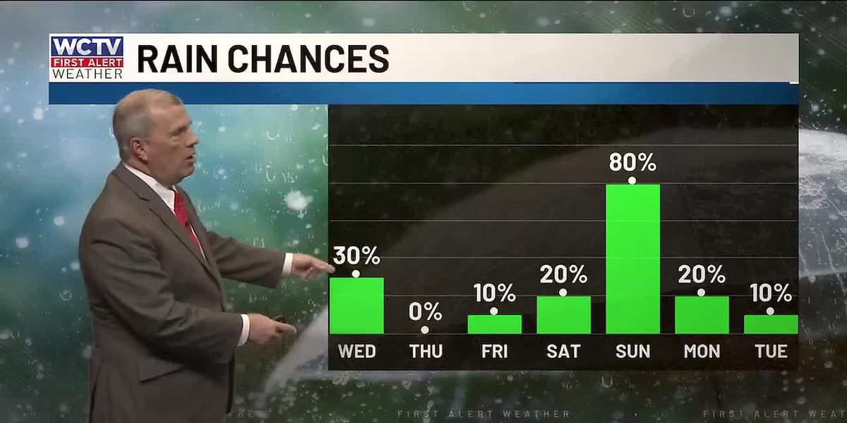
TALLAHASSEE, Fla. (WCTV) – Isolated showers are possible on Wednesday, but we are tracking higher rain chances for parts of the weekend.
Tonight Through Wednesday Night
Clouds begin to increase for Tuesday night as a weather system approaches the region. We are dry and a little foggy. Lows settle in the low-50s.
Our above-average weather will continue on Wednesday. Temperatures climb into the mid-and-upper-70s under a partly sunny sky. An isolated shower is possible, but it will not rain for everyone.
Again, a few showers are possible for Wednesday evening, but we are turning drier for the overnight. Lows bottom out in the low-50s under a partly cloudy to mostly clear sky.
Ending The Work Week
This February warmth will linger to end the work week.
Highs on Thursday and Friday top out in the mid-70s under a mostly sunny sky.
Overnight lows dip into the low-and-mid-40s.
Weekend Forecast
For the weekend, we are still keeping tabs on a stronger weather system.
Valentine’s Day is looking partly sunny and mild. Highs reach the mid-70s. A stray shower is possible, but most are looking dry. Lows fall into the mid-50s.
A cold front looks to sweep across the Big Bend and South Georgia on Sunday. This weather system will bring better chances for showers and a few thunderstorms.
Highs on Sunday hover in the mid-70s under a mostly cloudy sky. Lows fall into the low-50s.
To stay updated on all the latest forecasts and weather, follow WCTV First Alert Weather on Facebook and X (Twitter).
Click here to see all the latest weather headlines and here to view the First Alert Radar. Receive push alerts and watch the latest forecast anytime on the free WCTV First Alert Weather app. Click here to download it now.
Interested in becoming a WCTV First Alert Weather Watcher? Click here to join the team!
Copyright 2026 WCTV. All rights reserved.