
ORLANDO, Fla. – We’re just a couple days out from the weekend now that Wednesday has arrived. Computer models continue to project a fairly organized storm system to roll across the south and send impacts our way here in Central Florida.
DAYTONA BEACH, FL – FEBRUARY 26: Jamie McMurray, driver of the #1 Cessna McDonald’s Chevrolet, leads a pack of cars during the 59th Annual DAYTONA 500 at Daytona International Speedway on February 26, 2017 in Daytona Beach, Florida. (Photo by Brian Lawdermilk/Getty Images) (2017 Getty Images)
We know it’s coming, that much is certain. Now let’s spend a little time breaking down impacts together.
Timing this out, the worst of the effects should really arrive into town by Sunday night. Earlier model runs actually pointed towards earlier, which could help save race day for my NASCAR fans out there.
The GFS is the outlier once again with the cold front sweeping through early Monday morning, missing any impacts on Sunday altogether (Copyright 2026 by WKMG ClickOrlando – All rights reserved.)
The green flag is set to wave around 2:30 p.m., which gives us about 3-5 hours of race worthy weather before the cold front hits.
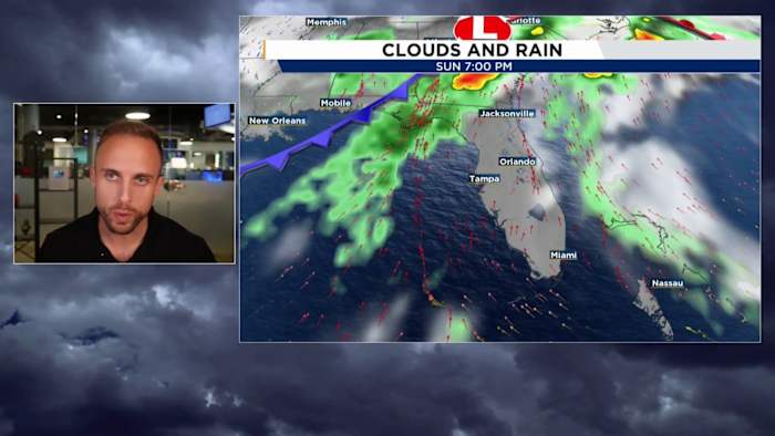
We’re still a little too far to see exactly what the radar could look like for Saturday and Sunday, as our higher resolution computer models typically go out 2-3 days at best.
Our lower resolution, global computer models, like the Euro and the GFS are starting to narrow down the window of rainy conditions to 7 p.m. Sunday night into early Monday morning.
The euro is sold there could be disruptions or a whole halt to the Daytona race midday Sunday (Copyright 2026 by WKMG ClickOrlando – All rights reserved.)
We should be prepared for periods of heavier rainfall, which is truthfully a much-needed blessing around these parts considering the increasing drought conditions.
There will likely be areas who witness some rare thunder and lightning. I say “rare” since it’s been so long since that Florida-synonymous phenomena has actually taken place.
While we won’t pick up much, it will still be a beneficial washing of rain this weekend (Copyright 2026 by WKMG ClickOrlando – All rights reserved.)
I’m still monitoring for the threat of strong thunderstorms. We’ve been warming up persistently, and as we wander through Friday and Valentine’s Day Saturday, we’ll see a bump up in the moisture department.
Pending when the cold front arrives here in the Florida Peninsula, we may have enough energy and juice present to get some extra lightning popping, and occasional gusty winds in your more organized storms.
Thankfully, it appears the threat for any severe weather continues to diminish as we get closer to the start time for all this.
With all cold frontal systems, we should anticipate for some sporty winds as well.
The further north you go Sunday into early Monday morning, the higher likelihood it is you receive some much-needed rainfall and maybe thunder and lightning (Copyright 2026 by WKMG ClickOrlando – All rights reserved.)
Before the passing of the cold front, winds out of the southwest could gust upwards of 15-25 mph before they back out of the northwest once that nose of cold air moves through.
The overall temperature drop here won’t be that excessive despite the winds we’ll feel along the backside of the storm.
You could call this more of a comfy front than a cold front. Temperatures in the morning will sink back into the upper 40s and low 50s with afternoon high’s leveling out somewhere in the low to mid 70s. Beautiful Florida weather in my very humble opinion.
Monday should be mostly clear, just breezy. If the front continues to move at the expected pace we’re seeing, your morning commute should see little weather related impacts as well.
Then we’re back to tracking warmer than average conditions as that subtropical ridge remains in place over the Gulf and southeast United States.
It almost looks like winter has concluded for the Sunshine State. I’ll have more to come on that momentarily.
Daily Forecast
The News 6 Weather team ensures you’re always on top of the day’s weather.
Copyright 2026 by WKMG ClickOrlando – All rights reserved.