
End Of Florida’s Drought in Sight? Timing Out Showers for the Daytona 500 | February 12th Forecast
End Of Florida’s Drought in Sight? Timing Out Showers for the Daytona 500 | February 12th Forecast
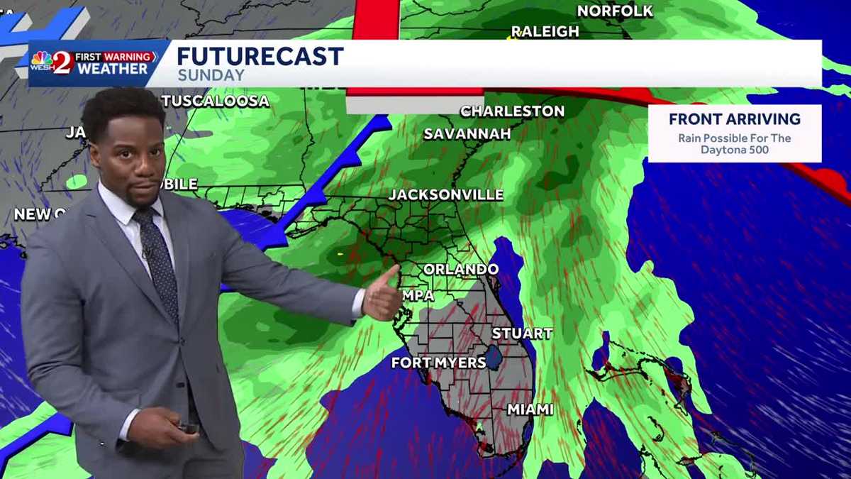
YOU NEED FOR THE LAKE COUNTY ANIMAL SHELTER. ALL RIGHT. I WAS OUTSIDE THIS MORNING RIGHT IN FRONT OF UNIVERSAL MARQUISE AND IT FELT VERY MISTY. IT WAS VERY FOGGY, BUT IT WAS ALSO MISTY. SO MUCH SO THAT I FELT LIKE MAYBE IT COULD POSSIBLY RAIN. I WAS VERY HOPEFUL FOR A SECOND, BUT I KNOW WE STILL GOT TO HANG ON TIGHT FOR A REAL GOOD DOUSING. I LOVE YOUR OPTIMISM. YEAH, I WAS, I HAD IT. WE MIGHT BE ABLE TO SQUEEZE OUT ONE MEASLY SHOWER LATER ON THIS AFTERNOON AND EARLY EVENING, BUT THE BETTER CHANCE FOR RAIN IS, OF COURSE, GOING TO BE THIS WEEKEND, RIGHT? SO WE’RE STILL A FEW DAYS AWAY, BUT WE DEFINITELY NEED THE RAIN DUE TO THE DEFICIT THAT WE’VE BEEN UNDER HERE IN CENTRAL FLORIDA. IN FACT, WIDESPREAD ACROSS CENTRAL FLORIDA. THERE IS A MASSIVE DEPARTURE FROM OUR SEASONAL AVERAGE, IN WHICH WE ARE UNDER A VERY CONSIDERABLE DROUGHT. NOW, THE BETTER CHANCE FOR SHOWERS. THAT, OF COURSE, IS GOING TO BE SUNDAY NIGHT INTO MONDAY. SO WE’LL BE WATCHING THE RADAR QUITE CLOSELY FOR THE DAYTONA 500. AND WE’RE STILL SOGGY. TO START OFF YOUR WORK WEEK COMING UP. NOTICE THE TEMPERATURE SHIFT THOUGH, RIGHT OVER THE COURSE OF THE WEEKEND. WE’RE GETTING WARMER AND WARMER CLIMBING INTO THE UPPER 70S BY SUNDAY, BUT WE GET KNOCKED DOWN A FEW EXTRA DEGREES MONDAY, DROPPING BACK INTO THE MIDDLE OF THE 70S RIGHT NOW ACROSS DAYTONA BEACH IN THE MID 60S WITH MOSTLY CLOUDY SKIES. WE’LL HAVE A BREEZE COMING IN FROM THE NORTH AND THE NORTHEAST FOLLOWING THE PASSAGE OF A VERY WEAK FRONTAL BOUNDARY. SO THAT’S WHAT’S KEEPING THE CLOUDS AROUND MOMENTARILY, BUT WILL BE MUCH DRIER TOMORROW. NOTICE THAT WE’RE RISING THOUGH, IN KISSIMMEE, SAINT CLOUD. YOU GUYS HAVE NOW SET A LOW TO THE 70S, AND WE STILL HAVE ROOM FOR THOSE NUMBERS TO INCREASE ACROSS YOUR AFTERNOON. BUT HERE’S THE WEAK FRONT THAT I WAS JUST MENTIONING DRAPED ACROSS THE I-4 CORRIDOR, PUSHING TOWARDS THE SOUTH AS WE CONTINUE ACROSS THE REST OF YOUR DAY. BUT WE WILL STILL SEE THE CHANCE FOR THESE CLOUDS TO SEPARATE AS WE MOVE ACROSS THE AFTERNOON. A LITTLE BIT MORE SUNSHINE THAT WILL PROPEL HIGHS INTO THE 70S TODAY. BUT AS I MENTIONED, WE HAVE A COUPLE DROPS OF RAIN THAT WILL BE TRYING TO SQUEEZE OUT THROUGHOUT THE DAY. BETTER CHANCES COME YOUR WAY JUST ON YOUR COMMUTE HOME AT FIVE, SIX AND 7:00, AND THEN BY NINE WE’RE DRY ONCE AGAIN, BUT WE HAVE A CHANCE FOR SOME PATCHY FOG TO WELCOME ITSELF BACK INTO THE FORECAST TONIGHT. FOG WILL BE GREATEST AS WE MOVE ACROSS SIX AND 7:00. NOTICE VISIBILITY RESTRICTIONS DROPPING DOWN TO A STATUTE MILE ACROSS LAKE COUNTY AND CLERMONT LEESBURG ONE AND A HALF. WILDWOOD ACROSS I-75, ONE AND A HALF STATUTE MILES TO JUST BE ON THE LOOKOUT FOR SOME PATCHY FOG, BUT ALSO BE ON THE LOOKOUT FOR RISING TEMPERATURES. WE’RE BACK ON TRACK TOMORROW AFTERNOON AS HIGHS RETURN TO THEIR SEASONAL AVERAGE. 76 ORLANDO SANFORD 75 DEGREES AND WILL CONTINUE TO RAISE THE BAR OVER THE COURSE OF YOUR WEEKEND. INLAND. WE’LL HIT THE 80S BY SUNDAY BEFORE ANOTHER COLD FRONT WORKS ITS WAY IN. WE’LL BE WATCHING THIS DUE TO THE FACT THAT WE HAVE A MAJOR EVENT. I DON’T KNOW IF YOU GUYS HAVE HEARD ABOUT IT. THE DAYTONA 500 TAKING PLACE ON SUNDAY, AND IT LOOKS LIKE MOST OF THE MODELS ARE PLACING THE RAIN SUNDAY NIGHT INTO MONDAY MORNING. SO THAT IS THE BEST CASE SCENARIO FOR US HERE IN CENTRAL FLORIDA. AS FAR AS RAINFALL ACCUMULATION IS CONCERNED, WE COULD POTENTIALLY SEE UP TO HALF AN INCH, MAYBE AN INCH IN SOME PLACES ALONG I-75 UP TOWARDS THE NORTH AND THE WEST, MAYBE 1 TO 2IN IN MARION COUNTY. SO WE CERTAINLY NEED IT AS THIS IS OUR A LOOK AT OUR DEPARTURE MELBOURNE NEARLY THREE INCHES BELOW SEASONAL DAYTONA BEACH 3.03 BELOW YOUR SEASONAL AVERAGE. SO WE NEED THE RAIN. WE’RE NOT GOING TO MAKE UP THAT DEFICIT IN ONE DAY, BUT ANY CHANCE IS GOING TO BE WELCOMED HERE IN CENTRAL FLORIDA, BUT TEMPERATURE WISE WILL BE WELCOMING THE LOWER
End Of Florida’s Drought in Sight? Timing Out Showers for the Daytona 500 | February 12th Forecast
End Of Florida’s Drought in Sight? Timing Out Showers for the Daytona 500 | February 12th Forecast

Updated: 1:53 PM EST Feb 12, 2026
End Of Florida’s Drought in Sight? Timing Out Showers for the Daytona 500 | February 12th ForecastAfter a foggy start to the morning, dense fog advisories will be lifting by 10:00 AM. There will be a few spotty chances for showers this afternoon but overall expect to remain partly sunny with highs returning to the mid seventies where the sun is shining brightest. Overall, temperatures will continue to increase through the weekend but be on the lookout for much needed rain swinging into Central Florida by Sunday. Highs to finish the weekend will rise into the lower eighties by Sunday Afternoon, but the timing of showers may impact the Daytona 500, so make sure to keep the rain gear close by if heading out to the event. Expect to remain soggy Monday morning as well, and just a bit cooler. Temps will fall back into the seventies to start your upcoming workweek.
End Of Florida’s Drought in Sight? Timing Out Showers for the Daytona 500 | February 12th Forecast
After a foggy start to the morning, dense fog advisories will be lifting by 10:00 AM. There will be a few spotty chances for showers this afternoon but overall expect to remain partly sunny with highs returning to the mid seventies where the sun is shining brightest. Overall, temperatures will continue to increase through the weekend but be on the lookout for much needed rain swinging into Central Florida by Sunday. Highs to finish the weekend will rise into the lower eighties by Sunday Afternoon, but the timing of showers may impact the Daytona 500, so make sure to keep the rain gear close by if heading out to the event. Expect to remain soggy Monday morning as well, and just a bit cooler. Temps will fall back into the seventies to start your upcoming workweek.