
ORLANDO, FLA. – Central Florida is definitely warming up, but the weather won’t stay quiet all Presidents’ Day weekend. Changes are coming, with wetter weather expected by late Sunday.
THURSDAY EVENING/NIGHT
A stationary front remains over the state, keeping things mostly cloudy through the remainder of the evening with a few stray showers.
Overnight lows dipping into upper 40s and 50s. Some patchy fog could form again late tonight into early Friday.
Lows tonight
FRIDAY & SATURDAY
Friday and Saturday look pretty nice overall.
The leftover front hangs nearby, but conditions stay mostly quiet. Expect a mix of sun and clouds with warmer air—highs reaching the upper 70s to around 80 degrees both days.
Highs tomorrow
SUNDAY & MONDAY
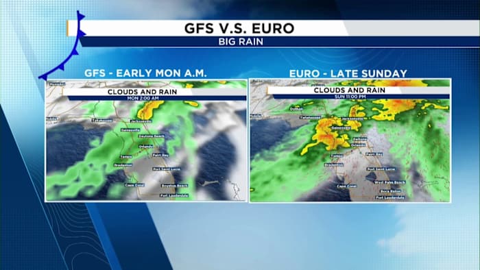
By Sunday, we’re keeping a close eye on the next cold front. Rain chances increase as the day goes on, with steadier showers and even a few storms possible Sunday night. It’ll also turn breezy and a bit gusty ahead of the front before winds shift and slightly cooler air settles in to start the new week.
We’re still working out the exact timing. The models don’t completely agree yet — one brings the rain in early Sunday, while another holds it off until later in the day.
So if you’ve got plans, just be ready for changes and keep that umbrella nearby.
Timing
If you’re heading to the Daytona 500, the good news is that right now the heaviest rain looks like it may hold off until after the race.
Still, a few spotty showers are possible during the afternoon, so it’s a good idea to have rain gear handy just in case.
Daytona 500 forecast
Highs settle back into the 70s, with cooler mornings in the 50s and low 60s, before we warm right back up again by midweek.
Copyright 2026 by WKMG ClickOrlando – All rights reserved.