
Damaging wind, hail possible Sunday in Central Florida | Impact Weather
YOU ON WESH.COM. LOOK FOR AS SEEN ON WESH TWO. THEY PICKED A GOOD WEEKEND TO DO A POLAR PLUNGE, AT LEAST FOR WARMING UP TO WHERE IT’S GOING TO FEEL NICER WHEN YOU HEAD OUT OF THE POOL, BUT MAN, WE’RE JUST COMING OUT OF THAT COLD STRETCH. IT’S NICE TO SEE A CHANGE HERE IN CENTRAL FLORIDA, RIGHT? I FEEL LIKE EARLIER LAST WEEK WE WERE TALKING ABOUT THE COLD WEATHER ADVISORIES, THE FREEZE WARNINGS. TEMPERATURES ARE MOVING IN THE OPPOSITE DIRECTION THIS WEEKEND. RIGHT? WILL BE PUSHING INTO THE MID 70S ON SATURDAY ALONG THE COAST AND THE UPPER 70S BEFORE SHOWERS AND STORMS MOVE IN. SO TEMPS ARE MOVING UP, BUT THE SHOWERS WILL BE COMING DOWN ON SUNDAY JUST AS THE DAYTONA 500 WILL BE COMING TO ITS CLOSE. THEN ON MONDAY, STILL A COUPLE SHOWERS TO START OFF THE MORNING, BUT ULTIMATELY WILL BE TRENDING A LITTLE BIT COOLER TO START OFF YOUR WORKWEEK. DIPPING DOWN INTO THE LOWER 70S BY TUESDAY, BUT RISING AGAIN AS WE HEAD INTO WEDNESDAY AND THURSDAY. LET’S GET YOU OUT TO THE BEACH RIGHT NOW. 66 DEGREES. NOT NECESSARILY BEACH WEATHER, BUT WE HAVE THAT BEAUTIFUL BEACH, SUNSHINE. PERFECTLY CLEAR SKIES ARE BACK IN NEW SMYRNA BEACH, AND YOU’RE A LITTLE BIT WARMER AS YOU MOVE NORTH ACROSS VOLUSIA COUNTY. 69 IN DAYTONA BEACH, 71 IN SANFORD. LOOKS LIKE YOU’VE JOINED THE 70S IN ORLANDO SHOWING 71 DEGREE TEMPERATURES HERE JUST BEFORE THE NOON TIME HOUR. BUT EVERYWHERE YOU LOOK IN CENTRAL FLORIDA, WE’VE GOT BEAUTIFUL SUNNY SKIES IN THE PICTURE TODAY. AND THAT’S WHAT WE’LL HOLD ON TO. TO START OFF YOUR WEEKEND AS WELL. NOTICE WE’LL STAY CLEAR TONIGHT AS TEMPERATURES DIP DOWN INTO THE MIDDLE OF THE 50S. BY MIDNIGHT HERE IN NEW SMYRNA. BUT YOUR RAIN CHANCES ARE ELEVATING AS WE MOVE THROUGHOUT THE WEEKEND. A 40% COVERAGE OF SHOWERS ON SUNDAY WILL HOLD ON TO A 50% COVERAGE OF SHOWERS. TO START OFF YOUR MONDAY MORNING, WE DO HAVE A SMALL CHANCE FOR SOME FOG TONIGHT WITH HIGH PRESSURE IN THE FORECAST AND CLEAR SKIES. YOU MIX THAT IN WITH A LITTLE BIT OF SURFACE MOISTURE, AND WE COULD SEE THAT VISIBILITY FROM I-4 PUSHING WEST BEGIN TO DROP. SO WATCH OUT FOR ANY POSSIBLE DENSE FOG ADVISORIES TONIGHT. BUT THE BIGGER STORY FOR THE WEEKEND WILL BE YOUR RISING TEMPERATURES BACK IN THE UPPER 70S IN ORLANDO TOMORROW, 78 DEGREES LEESBURG, 77 DAYTONA BEACH AND MELBOURNE BOTH HITTING 75 TOMORROW AFTERNOON. AND AS WE MOVE ACROSS THE WEEKEND, WE’RE ONLY GETTING WARMER. SUNDAY SHOWS HIGHS IN THE LOWER 80S, AND THAT COULD POTENTIALLY PRESENT SOME PROBLEMS. TYPICALLY AS TEMPERATURES RISE WITH A COLD FRONT MOVING IN. IT’S A RECIPE FOR SOME STRONGER STORMS, BUT I DO BELIEVE THE COLD FRONT WILL GET TO US ON SUNDAY NIGHT. SO THAT’S AFTER SUNSET. THEREFORE, THE TEMPERATURES WILL BE COOLING BY THE TIME THIS COLD FRONT DOES BEGIN TO SLIDE INTO CENTRAL FLORIDA. SO IT’S A WARM AFTERNOON ON SUNDAY. BUT THE TIMING OF THE COLD FRONT GOING TO BE ESSENTIAL. WITH THAT IN MIND, ONE OF THE STRONGER IMPACTS THAT WE WILL SEE ON SUNDAY IN REGARDS TO YOUR SEVERE WEATHER THREAT WILL BE STRONGER, GUSTY WINDS BEFORE THE FRONT GETS TO YOU IN ANY RAIN. NOTICE THAT WIND SPEEDS ARE PUSHING TOWARDS 40MPH IN MARION COUNTY, SO THAT SOUTH AND WESTERLY BREEZE, 37 MILE PER HOUR CONDITIONS ACROSS I-75 IN WILDWOOD BY 630. THAT’S RIGHT AROUND THE SAME TIME THE DAYTONA 500 COMES TO ITS END. SO WE’LL BE WATCHING THE SHOWERS PUSH ACROSS THE FORECAST WITH THAT CHANCE FOR SOME STRONG WINDS. AS FAR AS RAINFALL ACCUMULATION IS CONCERNED, WE COULD SEE SOME POCKETS OF RAIN BETWEEN 1 AND 2IN. SO NOT A HUGE RAIN THREAT, BUT WE HAVEN’T HAD MUCH RAIN SO FAR THIS YEAR, MANY OF US IN A 2 TO 3 INCH DROUGHT. SO SUNDAY WE’RE TIMING OUT. IMPACT WEATHER A FEW EXTRA SHOWERS ON MONDAY, THEN EXPEC
Damaging wind, hail possible Sunday in Central Florida | Impact Weather

Updated: 12:08 PM EST Feb 13, 2026
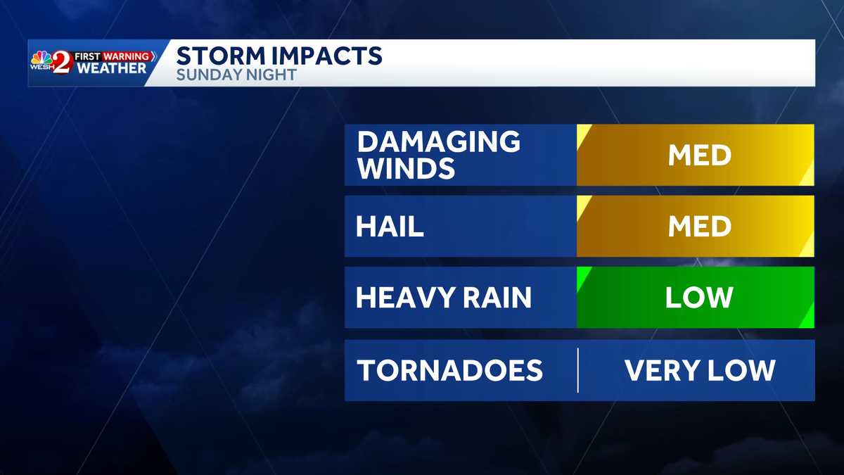
Damaging winds and hail are possible on Sunday in Central Florida when evening storms move through. That’s why the WESH 2 First Warning Weather team is calling for Impact Weather. Storms are expected in the early afternoon in Marion County, reaching eastern Volusia County a few hours later. Rain could delay the Daytona 500 on Sunday afternoon.>> Subscribe to the WESH 2 YouTube channelFuturecastFirst Warning Weather Stay with WESH 2 online and on-air for the most accurate Central Florida weather forecast.RadarSevere Weather AlertsDownload the WESH 2 News app to get the most up-to-date weather alerts. The First Warning Weather team includes First Warning Chief Meteorologist Tony Mainolfi, Eric Burris, Marquise Meda and Cam Tran.What is Impact Weather?Impact Weather suggests weather conditions could be disruptive or a nuisance for travel and day-to-day activities.
ORLANDO, Fla. —
Damaging winds and hail are possible on Sunday in Central Florida when evening storms move through.
That’s why the WESH 2 First Warning Weather team is calling for Impact Weather.
Storms are expected in the early afternoon in Marion County, reaching eastern Volusia County a few hours later.
Rain could delay the Daytona 500 on Sunday afternoon.

WESH 2 News
Sunday, Feb. 15, 2026
This content is imported from Twitter.
You may be able to find the same content in another format, or you may be able to find more information, at their web site.
Showers and storms will sweep across Central #florida Sunday evening and bring damaging winds, hail and the chance for a few marginally severe storms. The rain should hold off @DAYTONA until around 7-8 pm. SW Winds 20-30 could impact the driving. Stay with #weshwx for updates. pic.twitter.com/frPYrVfWOU
— Tony Mainolfi (@TMainolfiWESH) February 13, 2026
>> Subscribe to the WESH 2 YouTube channel
Futurecast
This content is imported from Twitter.
You may be able to find the same content in another format, or you may be able to find more information, at their web site.
This content is imported from Twitter.
You may be able to find the same content in another format, or you may be able to find more information, at their web site.
First Warning Weather
Stay with WESH 2 online and on-air for the most accurate Central Florida weather forecast.
Download the WESH 2 News app to get the most up-to-date weather alerts.
The First Warning Weather team includes First Warning Chief Meteorologist Tony Mainolfi, Eric Burris, Marquise Meda and Cam Tran.
What is Impact Weather?
Impact Weather suggests weather conditions could be disruptive or a nuisance for travel and day-to-day activities.