
Heavy rain, wind, hail possible Sunday in Central Florida | Impact Weather
ESPECIALLY DURING SEVERE WEATHER EVENTS. AND SPEAKING OF SEVERE WEATHER, LET’S CHECK IT OUT FIRST. WARNING METEOROLOGIST MARQUISE MEDA MARQUISE TOMORROW. NOT SEVERE, BUT DEFINITELY IMPACT WEATHER. SOMETHING WE WANT TO WATCH OUT FOR. YEAH, WE HAVE THE CHANCE FOR A FEW STRONGER STORMS. I DO BELIEVE ALL THROUGHOUT THE DAY WILL BE WATCHING THE WINDS, ESPECIALLY ONCE YOU MOVE ALONG THE I-75 CORRIDOR. DAMAGING WINDS CAN GUST UPWARDS OF 45MPH. OTHER THREATS THAT WE COULD STILL SHOW LOW IMPACTS FOR ANY CHANCE FOR NET SPIN UPS, THE CHANCE FOR HAIL, AND ALSO HEAVY RAIN. WE’LL HAVE SOME POCKETS WITH AN INCH OR MORE IN SOME AREAS HERE IN CENTRAL FLORIDA. AND THAT’S SUNDAY EVENING. AND SOME OF THESE RAIN SHOWERS WILL LINGER OUT THE DOOR ON MONDAY AS WELL. WE’LL TAKE YOU OUT TO ORLANDO RIGHT NOW. WHICH CONDITIONS ARE CALM? QUITE WARM, AS A MATTER OF FACT, WINDS FROM THE SOUTHEAST RIGHT NOW AT EIGHT MILES PER HOUR, HAVE TEMPERATURES IN THE MIDDLE OF THE 60S, 66 DEGREES, WITH A BLANKET OF CLOUDS OVERHEAD. AND WE’RE NOT THE ONLY ONE IN THE MID 60S HERE IN ORLANDO, CLERMONT YOU MATCH THAT KISSIMMEE 66 AS WELL. SAINT CLOUD, 66 DEGREES. ALSO NEW SMYRNA BEACH, YOU’RE IN THE MID 60S JUST LIKE OCALA. YOUR 12 HOUR FORECAST AS WE CONTINUE ACROSS THE REST OF YOUR VALENTINE’S DAY EVENING, DOES SHOW TEMPERATURES SLOWLY CRAWLING INTO THE LOWER 60S. BEFORE WE START TO SKYROCKET TOMORROW, THAT SOUTHERLY COMPONENT OF YOUR WINDS WILL REALLY DO ITS JOB IN AIDING TO WARM UP YOUR TEMPERATURES. EVEN WITH A FEW EXTRA CLOUDS IN THE FORECAST FOR THE REST OF TONIGHT, THOUGH, ACROSS CENTRAL FLORIDA WILL WIND DOWN ANYWHERE BETWEEN 57 TO 6666 DEGREE TEMPERATURES OVERNIGHT, WITH LIGHT WINDS COMING IN WITH LIGHT WINDS IN THE FORECAST FOR TONIGHT, WE DO RUN THE RISK FOR A LITTLE BIT OF PATCHY FOG SOUTH ACROSS I-4, DROPPING YOUR VISIBILITY DOWN BELOW THREE STATUTE MILES. BUT ULTIMATELY THAT FOG WILL LIFT AS TEMPERATURES WILL RISE QUICKLY TOMORROW. NOTICE THAT WE SAY HELLO TO THE 80S HERE IN ORLANDO, BUT KEEP IN MIND WE’RE STILL TRACKING IMPACT WEATHER WITH THE CHANCE FOR STRONGER STORMS ONCE WE MOVE INTO THE EVENING. BUT WE COULD SEE SOME OF THOSE SHOWERS AND STORMS ACROSS I-75 AS EARLY AS 4 OR 5:00. NOW, THIS FRONTAL BOUNDARY SUPPLYING US WITH THE STORMS FOR TOMORROW IS SLOWING DOWN A LITTLE BIT. WE RUN THESE MODELS HOUR BY HOUR. I’LL SHOW YOU THAT IN A SECOND. BUT HERE’S WHERE THE SEVERE THREAT DOES LIE. TODAY, ACROSS THE NORTH AND WESTERN GULF. TOMORROW IT’S RIGHT INTO THE SUNSHINE STATE, ESPECIALLY ALONG THE I-10 AND I-75 CORRIDORS IN WHICH WE’RE WATCHING OUT FOR THOSE DAMAGING WINDS. HAIL. AS I MENTIONED, HEAVY RAIN. AND YOU CAN’T RULE OUT THE SMALL CHANCE FOR AN ISOLATED TORNADO SPIN UP. SO BEFORE THE SHOWERS GET HERE, BREEZY ALL THROUGHOUT CENTRAL FLORIDA, NOTICE THOSE STRONG WINDS FROM THE SOUTH AND THE WEST HAVE GUSTS UP TO 30MPH. LOOK AT OCALA THOUGH 40 MILE PER HOUR CONDITIONS WITH THAT LINE OF SHOWERS MOVING IN AT 630 NOW. SO A LITTLE BIT LATER. AND THAT’S ACTUALLY BETTER NEWS FOR US BECAUSE AS TEMPERATURES COOL AFTER SUNSET, WE’RE GOING TO LOSE SOME OF THE HEATING ELEMENTS THAT SUPPLY US WITH THOSE STRONGER CHANCES FOR HIGHER INSTABILITY AND STRONGER STORMS. SLOW MOVING FRONT, THOUGH STILL ACROSS THE I-4 CORRIDOR AT 10:00. SHOWERS INTO DAYTONA BEACH AT THAT TIME, NOW PUSHING TOWARDS THE SOUTH AND THE EAST, AND WE CAN STILL SEE SOME SHOWERS TO OUR SOUTH EARLY OUT THE DOOR ON MONDAY MORNING FOR BREVARD COUNTY. TRACKING THAT CHANCE FOR ANY TORNADO SPIN UPS THIS YEAR. ROTATION RISK ONLY ABOUT A 5% CHANCE WHERE WE HAVE THIS AREA OF GREEN 5 TO 10% CHANCE NOW MOVING ACROSS I-4 AT TEN 11:00, PUSHING OUT TOWARDS THE EAST INTO THE ATLANTIC JUST OVERNIGHT. AND THEN FUTURECAST HAS THAT FRONT PUSHING OFFSHORE MONDAY MORNING. HIGH PRESSURE SETTLES IN AND WE’LL FOLLOW THAT WITH WARMER CONDITIONS. DAYTONA BEACH WILL HIT THE 80S BY THURSDAY AND WE COULD DO SO EVEN EARLIER. INLAND 82 DEGREES ON WEDNESDAY, 83 ON THURSDAY. BUT KEEP IN MIND WE’RE STILL TRACKING THAT CHANCE FOR I
Heavy rain, wind, hail possible Sunday in Central Florida | Impact Weather

Updated: 11:03 PM EST Feb 14, 2026
Damaging winds and hail are possible on Sunday in Central Florida when evening storms move through. That’s why the WESH 2 First Warning Weather team is calling for Impact Weather. Storms are expected in the early afternoon in Marion County, reaching eastern Volusia County around 5 p.m. The greatest impact, including gusty winds up to 45 miles per hour, will be north of the metro area Sunday night.>> Download the WESH 2 app to stay up-to-date on breaking news and weatherNASCAR officials announced that the start time for Sunday’s Daytona 500 has been moved up an hour due to the threat of inclement weather. >> Subscribe to the WESH 2 YouTube channelFuturecastFirst Warning Weather Stay with WESH 2 online and on-air for the most accurate Central Florida weather forecast.RadarSevere Weather AlertsDownload the WESH 2 News app to get the most up-to-date weather alerts. The First Warning Weather team includes First Warning Chief Meteorologist Tony Mainolfi, Eric Burris, Marquise Meda and Cam Tran.What is Impact Weather?Impact Weather suggests weather conditions could be disruptive or a nuisance for travel and day-to-day activities.
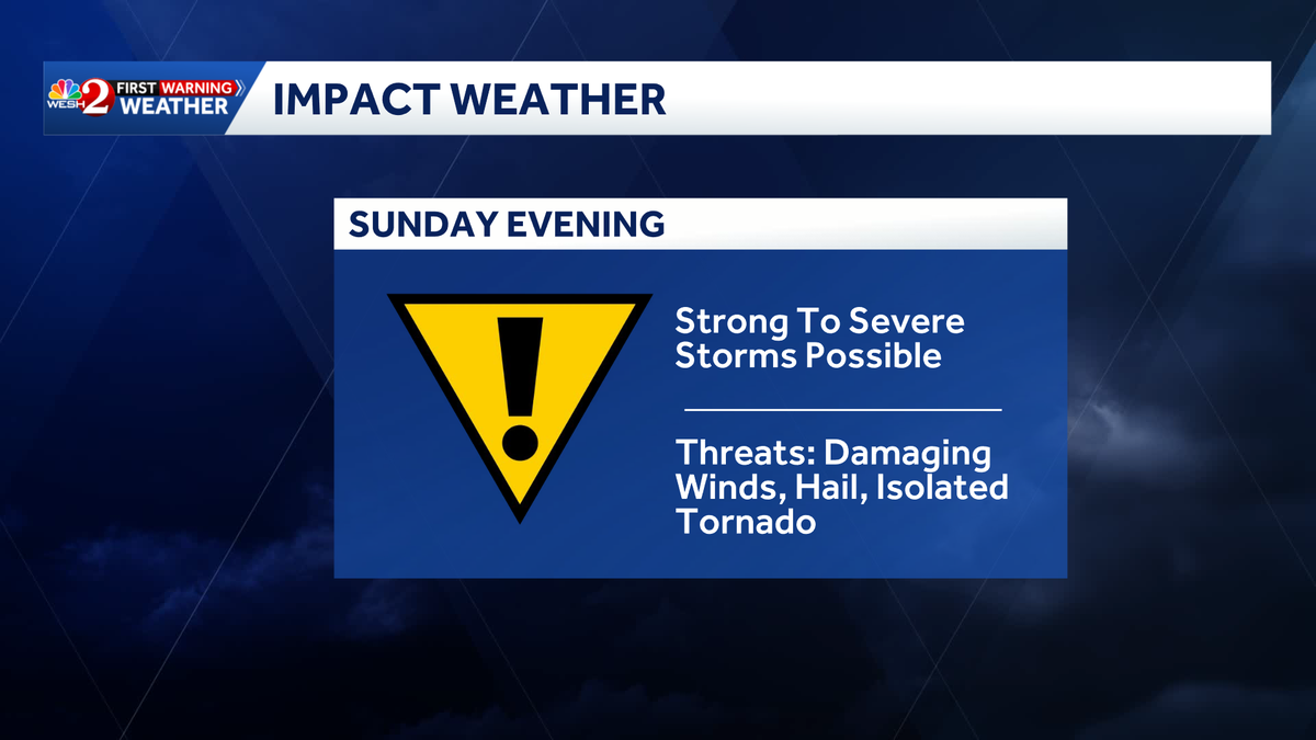
Damaging winds and hail are possible on Sunday in Central Florida when evening storms move through.
That’s why the WESH 2 First Warning Weather team is calling for Impact Weather.
Storms are expected in the early afternoon in Marion County, reaching eastern Volusia County around 5 p.m.
The greatest impact, including gusty winds up to 45 miles per hour, will be north of the metro area Sunday night.
This content is imported from Facebook.
You may be able to find the same content in another format, or you may be able to find more information, at their web site.
>> Download the WESH 2 app to stay up-to-date on breaking news and weather
NASCAR officials announced that the start time for Sunday’s Daytona 500 has been moved up an hour due to the threat of inclement weather.


>> Subscribe to the WESH 2 YouTube channel
Futurecast
This content is imported from Twitter.
You may be able to find the same content in another format, or you may be able to find more information, at their web site.
First Warning Weather
Stay with WESH 2 online and on-air for the most accurate Central Florida weather forecast.
Download the WESH 2 News app to get the most up-to-date weather alerts.
The First Warning Weather team includes First Warning Chief Meteorologist Tony Mainolfi, Eric Burris, Marquise Meda and Cam Tran.
What is Impact Weather?
Impact Weather suggests weather conditions could be disruptive or a nuisance for travel and day-to-day activities.