
Strong storms may bring damaging winds to Central Florida this evening | Impact Weather
REALLY POTENT STORM SYSTEM THAT’S ACTUALLY MOVING ACROSS THE SOUTH. YOU CAN SEE IT RIGHT THERE, THAT AREA OF LOW PRESSURE THAT’S NEAR JACKSON, MISSISSIPPI. AND THEN THAT RED POLYGON OR BOX THAT YOU SEE, THAT’S THE TORNADO WATCH ASSOCIATED WITH THAT STORM SYSTEM. AND IN ORDER FOR US TO FORECAST THE FUTURE, WE TYPICALLY HAVE TO TAKE A LOOK AT THE HISTORY OF A STORM. AND HERE’S A LOOK AT ALL THE WIND REPORTS AND EVEN TORNADO REPORTS OR FUNNEL CLOUD REPORTS THAT HAVE BEEN ASSOCIATED WITH THIS LINE OF THUNDERSTORMS. AND THIS LINE WILL BE HEADING IN OUR DIRECTION THIS EVENING. TAKE A LOOK AT OUR SATELLITE AND RADAR RIGHT NOW. NOT MUCH. IT’S PRETTY QUIET OUT THERE AND ACTUALLY A MILD START TO YOUR SUNDAY MORNING. CLOUDS WILL INCREASE AS WE GO THROUGHOUT THE DAY AS WELL AS THOSE WINDS. WE ARE LOOKING AT WIND GUSTS AS STRONG AS 35 IN THE METRO, BUT UP NORTH AUGUSTA STRONG AS 45MPH. SO IF YOU ARE CELEBRATING VALENTINE’S DAY OR YOU’RE HEADING OUT TO BRUNCH AGAIN, NOT LOOKING BAD. WE WILL SEE CLOUDS AROUND THEN AS WE GO INTO AROUND DINNER TIME. THIS IS WHEN WE’LL HAVE TO WATCH VERY CLOSELY HERE FOR THAT LINE OF SHOWERS AND THUNDERSTORMS WILL BE RIGHT OVER MARION AND FLAGLER COUNTIES BY ABOUT, I WOULD SAY 5 TO 6:00. I THINK THIS FUTURECAST MODEL IS ABOUT AN HOUR BEHIND HERE. SO 5 TO 6 OVER MARION AND FLAGLER COUNTIES. AND THEN YOU CAN SEE IT’S RIGHT OVER VOLUSIA AS WELL AS SEMINOLE COUNTIES, LAKE AND SUMTER COUNTIES. I WOULD SAY BETWEEN 8 TO 9 AND THEN HEADING TOWARDS I-4 CORRIDOR RIGHT AROUND 8 TO 9 AS WELL. ORLANDO ON SOUTH. AND THEN AS WE GO INTO AROUND 9 TO 10:00 IN THE EVENING, IT WILL BE JUST SOUTH OF ORLANDO AND THEN OVER BREVARD COUNTY BY ABOUT 1011. AND THEN YOU CAN SEE BY MIDNIGHT EVERYTHING CLEARS OUT. WE’RE LOOKING AT MOSTLY CLOUDY SKIES TOMORROW MORNING, A FEW SHOWERS, BUT THE RAIN WILL BE LONG GONE BY TOMORROW AFTERNOON AND WE ARE LOOKING AT SOME BENEFICIAL RAIN ASSOCIATED WITH THIS LINE OF THUNDERSTORMS THAT’S GOING TO BE MOVING THROUGH. WE JUST DON’T WANT THE SEVERE WEATHER ASPECT OF IT. SO ONCE THIS IS ALL SAID AND DONE, WE COULD PICK UP ABOUT A HALF AN INCH OF RAIN FOR MOST OF US. A FEW LOCALIZED AREAS, ESPECIALLY UP TO THE NORTH, COULD PICK UP A LITTLE OVER AN HALF AN INCH. BUT UNFORTUNATELY, AS THAT LINE PUSHES THROUGH, THERE IS THAT SMALL THREAT FOR SOME SEVERE WEATHER WITH DAMAGING WINDS. IN MY OPINION, THE BIGGEST THREAT. HOWEVER, I CAN’T RULE OUT THE ISOLATED TORNADO THREAT SOMETIMES WITH THESE SQUALL LINES THAT COME THROUGH, YOU DO GET A LITTLE BIT OF BOWING WITH IT, AND IT’S AROUND THOSE. A LITTLE EDGE OF THE BOWS THAT WE COULD SEE, A LITTLE SPIN UP. SO WE’RE WATCHING THAT POTENTIAL FOR ESPECIALLY THE HIGHEST RISK WILL BE FOR AREAS NORTH OF ORLANDO. HAIL RISK TODAY IS THERE, BUT IT LOOKS TO BE RATHER LOW. THIS MORNING THOUGH. MILD START TO THE DAY TIME NOW. FIVE 5064 RIGHT NOW IN PALM COAST. 6568 DAYTONA BEACH. IT’S GOING TO BE RATHER WARM AFTERNOON. LOOK AT THIS. A HIGH OF 83 IN SANFORD, 83 IN LEESBURG LATER TODAY, 80 IN TITUSVILLE. SO FEELING MORE LIKE SPRING. SO UP UNTIL DINNER TIME, IT’S A GOOD DAY TO GET OUTSIDE. IF YOU’RE HEADING OUT TO ATTRACTIONS. AGAIN, NOT A BAD ONE, BUT IT WILL BE RATHER WARM AND WINDY, AND THEN WE’LL HAVE TO KEEP OUR EYES THE SKIES RIGHT AROUND DINNER TIME AND THEREAFTER. SO BREAKING OUT YOUR CENTRAL FLORIDA CERTIFIED MOST ACCURATE SEVEN DAY FORECAST IMPACT WEATHER TODAY. BECAUSE OF THAT POTENTIAL FOR STRONG TO SEVERE THUNDERSTORMS THIS EVENING, A FEW LINGERING SHOWERS INTO YOUR PRESIDENT’S DAY, AND THEN AFTER THAT, THE REST OF PRESIDENTS DAY IS ACTUALLY LOOKING QUITE NICE. WITH A HIGH OF 74 AND A VERY BEAUTIFUL DAY FOR TUESDAY, THE START OF LUNAR NEW YEAR. AND
Strong storms may bring damaging winds to Central Florida this evening | Impact Weather

Updated: 7:29 AM EST Feb 15, 2026
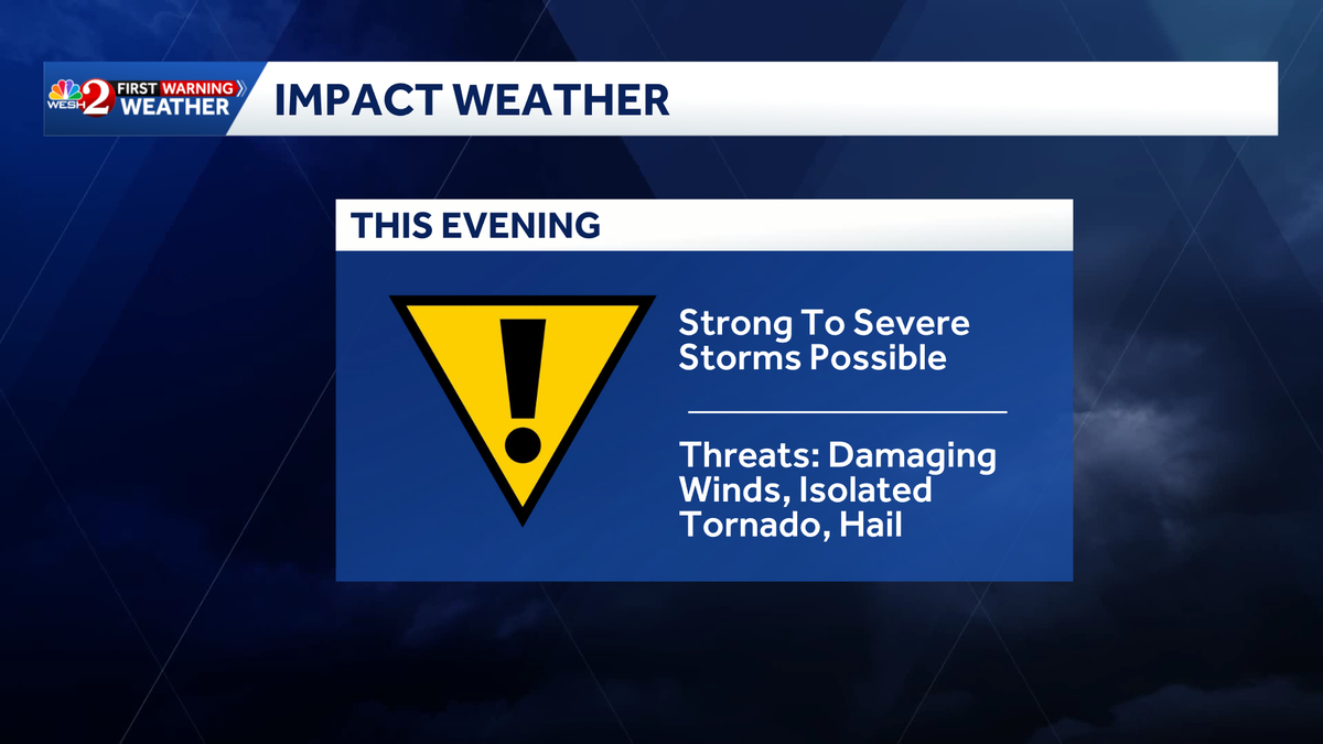
Damaging winds, hail, and even an isolated tornado are possible across Central Florida this evening as storms move through the area.That’s why the WESH 2 First Warning Weather team is calling for Impact Weather.Strong to severe storms are possible between 5 p.m. and 11 p.m., beginning in our northern counties before pushing south through the evening.NASCAR officials announced that the start time for Sunday’s Daytona 500 has been moved up an hour due to the threat of inclement weather.First Warning Meteorologist Cam Tran said a few showers are expected early Monday then clearing by the afternoon. First Warning WeatherStay with WESH 2 online and on-air for the most accurate Central Florida weather forecast.RadarSevere Weather AlertsDownload the WESH 2 News app to get the most up-to-date weather alerts.The First Warning Weather team includes First Warning Chief Meteorologist Tony Mainolfi, Eric Burris, Marquise Meda and Cam Tran.What is Impact Weather?Impact Weather suggests weather conditions could be disruptive or a nuisance for travel and day-to-day activities.
ORLANDO, Fla. —
Damaging winds, hail, and even an isolated tornado are possible across Central Florida this evening as storms move through the area.
That’s why the WESH 2 First Warning Weather team is calling for Impact Weather.
Strong to severe storms are possible between 5 p.m. and 11 p.m., beginning in our northern counties before pushing south through the evening.

NASCAR officials announced that the start time for Sunday’s Daytona 500 has been moved up an hour due to the threat of inclement weather.
First Warning Meteorologist Cam Tran said a few showers are expected early Monday then clearing by the afternoon.


First Warning Weather
Stay with WESH 2 online and on-air for the most accurate Central Florida weather forecast.
Download the WESH 2 News app to get the most up-to-date weather alerts.
The First Warning Weather team includes First Warning Chief Meteorologist Tony Mainolfi, Eric Burris, Marquise Meda and Cam Tran.
What is Impact Weather?
Impact Weather suggests weather conditions could be disruptive or a nuisance for travel and day-to-day activities.