
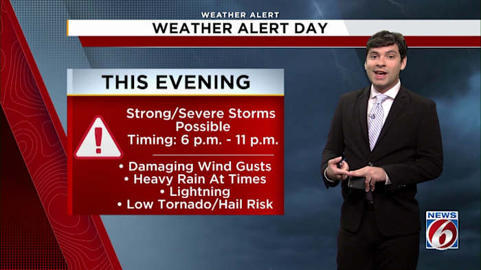
ORLANDO, Fla. – Strong to severe storms are expected to move into the area Sunday evening, with the highest risk stretching from about 6 p.m. into the early overnight hours, thanks to a strong cold front pushing through.
Most of Central Florida is under a “marginal” risk for severe weather, with a “slight” risk category for parts of Marion and Flagler counties in the north.
Severe Weather Risk for Central Florida Sunday
The far southern parts of the area are expected to be less at risk. The main window for these storms is expected between this evening and close to midnight, so it’s a good idea to stay weather-aware if you have evening plans.
[EXCLUSIVE: Become a News 6 Insider (it’s FREE) | PINIT! Share your photos]
Predicted hazards: Damaging winds, heavy rain, lightning, possible tornadoes
The most significant threats with this system include damaging wind gusts with some locations potentially seeing up to 45 mph.
Wind Advisory In Effect From Noon to 6 p.m
A wind advisory will be in effect from 12 p.m. to 6 p.m. for Marion and Flagler counties, but gusty conditions are forecast throughout the region.
Clouds And Rain Model for This Evening
Lightning and periods of heavy rain are possible as these storms roll through. While the chances for hail and flooding are on the lower side, an isolated tornado or two still cannot be completely ruled out in tonight’s setup.
Some drought relief from beneficial rain
A beneficial soaking is forecast with the storms, bringing in about a quarter to a half inch of rain. Some areas, especially farther north, could see totals near one inch.
Rain Forecast
While it’s not enough to end the drought, any precipitation will help—especially since drought monitor graphics show Marion and Flagler counties in the “extreme” drought category and much of Central Florida in the “moderate to severe” range.
Latest Drought Monitor
Looking ahead, can expect a slight cool-down for Presidents Day Monday with a high of 75 degrees and mostly cloudy skies. Tuesday will be warmer, around 79 degrees, and temperatures should return to the low 80s by midweek.
Snapped photos or videos of a storm at your place? Share what you’re seeing in your neighborhood on ClickOrlando.com with the PinIt! feature at this link.
[6 THINGS TO DO: Feb. 13-15]
News 6 Weather Insider
More Stories Like This In Our Email Newsletter
Copyright 2026 by WKMG ClickOrlando – All rights reserved.