
TALLAHASSEE, Fla. (WCTV) – Get ready for a warm-up this week. Temperatures will surge into the 80s Thursday through Saturday, with a real chance of nearing records across the Big Bend and South Georgia.
Drying out to start the week
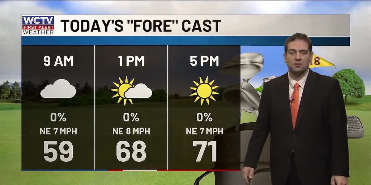
Clouds this morning behind yesterday’s strong storm system that brought beneficial rain to the area. Temperatures are in the 50s and 60s out the door.
Be sure to grab the sunglasses, though. Clouds will break and diminish through the afternoon, leading to a bright end to our Monday. Highs will reach the low 70s.
I know many folks are off and school is out for Presidents’ Day, so if you find yourself heading to the coast, the waters are rough.
A High Risk of Rip Currents is in effect at all Gulf beaches through late tonight. With the waters rough, swimming conditions will be dangerous. Rip currents can pull swimmers away from shore quickly and are difficult to escape if you don’t know what to do.
For boaters and fishermen, low stratus clouds extend past the coast and waves between 4 and 8 feet, especially in the morning. Winds do settle this evening, falling between 5 and 10 knots.
Warming trend ahead
High pressure is settling in over the Gulf, bringing warmer-than-normal temperatures through at least Saturday. Here’s the breakdown:
Tuesday and Wednesday: A gradual warm-up with highs in the middle to upper 70s as the pattern becomes more favorable for warmth.
Thursday through Saturday: This is where it gets really warm. Expect highs in the 80s across much of the area away from the immediate coast.
Record highs are in the low 80s late week, so we will be flirting with records Thursday through Saturday.
A few showers will be possible as this weather setup favors an onshore wind, which will bring higher humidity levels and moisture to North Florida and South Georgia. Fog will likely start to become more frequent midweek to late week as well.
Weekend front
A cold front will slide through the southeast late weekend. This will bring the highest chance of rain in your 7-day forecast. This cold front will also bring another drop in temperatures by early next week. Still some uncertainty regarding the exact timing of the front. This will be something to monitor through the week. No concerns about severe weather right now.
To stay updated on all the latest forecasts and weather, follow WCTV First Alert Weather on Facebook and X (Twitter).
Click here to see all the latest weather headlines and here to view the First Alert Radar. Receive push alerts and watch the latest forecast anytime on the free WCTV First Alert Weather app. Click here to download it now.
Interested in becoming a WCTV First Alert Weather Watcher? Click here to join the team!
Copyright 2026 WCTV. All rights reserved.