
ORLANDO, Fla. – Central Florida is about to get a reminder that winter isn’t done yet, with near-record heat late this week followed by a sharp blast of colder air into early next week.
Record-chasing heat
Afternoon highs will soar into the mid to upper 80s Friday and Saturday, nearing records from the late 1980s. This could be the warmest stretch since early November.
A brisk cold front Sunday will bring a few scattered showers and set the stage for the dramatic temperature drop early next week.
Records vs Highs SaturdayWinter blast arrives
By Monday, highs will be noticeably colder as temperatures struggle to get out of the 60s.
Forecast Highs Monday
The colder air deepens Monday night, setting the stage for a chilly Tuesday morning. Temperatures are forecast to dip into the 30s across parts of the area.
Forecast Lows Tuesday
With a lingering breeze, wind chills could make it feel like the 20s during the early morning hours.
Wind Chill Tuesday Morning
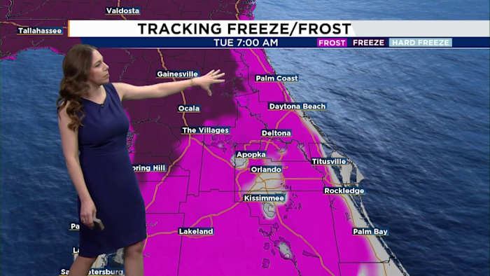
There is even a potential for frost Tuesday morning for many neighborhoods west of I-95.
Frost Potential Tuesday Morning
While we are still technically in winter, our window for strong cold fronts is beginning to close.
Last days in the 60s
Climatologically, Central Florida typically sees its last significant winter-like fronts around spring break season in mid-March. That makes this upcoming cold blast potentially one of our final true tastes of winter.
Daily Forecast
The News 6 Weather team ensures you’re always on top of the day’s weather.
Copyright 2026 by WKMG ClickOrlando – All rights reserved.