
ORLANDO, Fla. – If you have been enjoying the summer-like feel lately, do not get too comfortable because Central Florida is heading on quite a rollercoaster ride, including record heat, rain and frost.
FRIDAY & SATURDAY
Friday and Saturday stay warm and mainly dry, with highs nearing record levels in the mid-to-upper 80s inland.
Forecast vs. Record Friday
Friday’s forecast highs are putting records in jeopardy across the region:
Orlando: Forecast 87° | Record 89° (set in 1988)
Sanford: Forecast 87° | Record 86° (set in 2019)
Daytona Beach: Forecast 84° | Record 85° (set in 1988)
Leesburg: Forecast 87° | Record 86° (set in 2018)
For those spending the day along the coast or enjoying the beaches, a light sea breeze should keep highs in the low 80s, but there will be a high risk of rip currents.
Highs Saturday
Saturday’s forecast highs vs records:
Orlando: Forecast 88° | Record 88° (set in 1989)
Sanford: Forecast 87° | Record 87° (set in 2003)
Daytona Beach: Forecast 84° | Record 87° (set in 1989)
Leesburg: Forecast 87° | Record 87° (set in 2018)
SUNDAY
Our rain chances remain very low through most of Saturday, though a slight chance of showers could develop late Saturday north of Orlando as the next cold front approaches.
With the continued warmth and lack of meaningful rainfall, drought conditions and fire sensitivity will continue to increase.
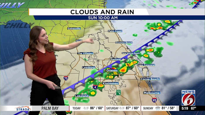
Rain Chances Sunday
The big temperature swing begins as a strong cold front moves through the area Sunday morning and into the afternoon. Rain chances along the front will bring rain chances to 40-50% with a low threat for lightning.
Rainfall totals look minimal, which won’t do much to improve our drought conditions.
Once the front clears, dry and breezy conditions move in with highs nearing 80.
NEXT WEEK
By Monday, winter makes a quick comeback.
High temperatures Monday and Tuesday will struggle to reach the upper 50s to low 60s in many areas.
Cold Blast Look Ahead
Overnight lows are expected to drop into the 30s across most inland areas Tuesday and Wednesday mornings.
Wind chills could dip into the 20s and 30s at times, which could trigger a Cold Weather Advisory.
Wind Chill Tuesday Morning
Along with the chilly temperatures, frost could be a possibility through midweek.
Daily Forecast
The News 6 Weather team ensures you’re always on top of the day’s weather.
Copyright 2026 by WKMG ClickOrlando – All rights reserved.