
Cold air moving in, fire danger rising in Central Florida
HERE ON THE END OF IT. I MEAN, LOOK AT THE SEVEN DAY FORECAST, OKAY? BECAUSE THE NEXT FEW DAYS IT IS BITTER COLD, HIGH TEMPERATURE TODAY STAYS IN THE 50S. AND TO GIVE YOU AN IDEA, OUR AVERAGE LOW TEMPERATURE THIS TIME OF YEAR IN FEBRUARY MIND YOU SHOULD BE IN THE 50S TOMORROW MORNING. IT’S EVEN COLDER 35 DEGREES. WE’LL WAKE UP TO THE 30S AGAIN ON WEDNESDAY, BUT AT LEAST WE START TO HEAL. WE GET BACK INTO THE 80S AND THEN INTERESTINGLY ENOUGH, WE ACTUALLY WATCH NOT JUST SHOWERS, BUT THUNDER SHOWERS IN THE FORECAST OUTSIDE. RIGHT NOW IT’S 46. IN THE CITY. IT’S 44 IN SANFORD, 43 DAYTONA BEACH AND WE’RE IN THE UPPER 30S IN OCALA. BUT YOU FACTOR IN A FIVE, TEN, EVEN 15 MILE PER HOUR BREEZE, AND IT FEELS LIKE THE 30S ACROSS THE AREA. SO WHERE DO WE GO FROM HERE? 56 DOES IT IN ORLANDO. SAME THING FOR KISSIMMEE IN SAINT CLOUD, ABOUT 54 DEGREES IN OCALA, 55 DEGREES IN DELAND AND 59 IN MELBOURNE. IT’S A COLD ONE TOMORROW MORNING THOUGH. LOOK AT THE NUMBERS IN YOUR NEIGHBORHOOD. WAKING UP WATERFORD LAKES TO 3534 IN MAITLAND. I THINK WE’LL BE AT FREEZING AND JUST BELOW FROM APOPKA, BACK OVER TO ZELLWOOD AROUND DISNEY, 3232 DEGREES IN WINDERMERE. LOOK HERE INTO SEMINOLE AND VOLUSIA COUNTY, 33, OVIEDO, 32, IN SANFORD, 30 DEGREES IN DELAND, 31 DEGREES IN DELTONA AND THEN OUT WEST WE GET INTO THE 20S. THESE ARE AIR TEMPERATURES, MIND YOU, 28 IN OCALA, 25 IN DUNNELLON, 28 DEGREES IN SALT SPRINGS, 32 DEGREES IN MOUNT DORA, 31 IN CLERMONT AND IN BREVARD COUNTY WILL BE IN THE 30S TO LOWER 40S, ESPECIALLY WHEN YOU HEAD INLAND, THOUGH WE DROP OFF REAL QUICK. 32 HERE IN SAINT CLOUD AND ABOUT 31 IN POINCIANA. WE HAVE FREEZE WARNINGS IN EFFECT FOR NEARLY ALL OF US TOMORROW MORNING, FOR OBVIOUS REASONS. BUT WHILE WE DO SET WITH THOSE CHILLY TEMPERATURES, NOTICE THE AFTERNOONS DO START TO WARM UP BY WEDNESDAY AND THURSDAY. SO WATCHING THAT COLD AIR DIVING IN NOW. BUT THE CONCERN HERE IS THAT IT DRIVES UP THE FIRE DANGER THIS AFTERNOON BECAUSE WE’VE GOT THE DRY VEGETATION, THE DRY ATMOSPHERE AND THE GUSTY WINDS. THAT’S GOING TO KEEP US WITH A HIGH FIRE DANGER TODAY. AND THEN LOOKING AHEAD TOWARD TUESDAY, WEDNESDAY, THURSDAY, THOSE INGREDIENTS COME DOWN JUST A LITTLE BIT. BUT FOR NOW, BLIZZARD IN THE NORTHEAST THROWING DOWN THIS COLD, DRY AIR FOR US. OVER THE NEXT COUPLE OF DAYS, WE’LL STAY CHILLY. THEN WE START TO WARM UP MID TO LATE WEEK, AND THEN AT THE VERY END OF THE WORKWEEK, WE START TO WATCH OUR NEXT STORM SYSTEM MOVING IN. THAT’S THAT COLD FRONT THAT, ACCORDING TO ALL THE MODELS, BASICALLY SET US UP FOR A PRETTY WET DAY ON FRIDAY, SATURDAY, AND EVEN LOOKING AHEAD TO SUNDAY FOR NOW, IT’S CLEAR IT’S COLD TEMPERATURES OUT THE DOOR IN THE 30S FOR SOME 40S. FOR MOST OF US
Cold air moving in, fire danger rising in Central Florida

Updated: 6:07 AM EST Feb 23, 2026
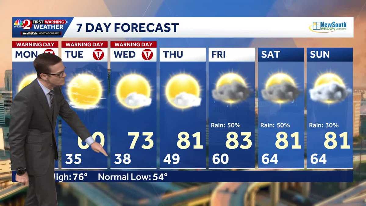
Cold, dry, and gusty conditions are prompting a Severe Weather Warning Day alert on Monday morning. This is all due to the combination of cold air and high fire danger in the area. Today, temperatures will struggle to climb above the mid-50s. Tonight, another cold forecast is expected, with temperatures falling to the 20s in the northwest and 30s in the metro area. The cold weather will persist through Wednesday, with Severe Weather Warning Day alerts issued from Monday to Wednesday. Temperatures are expected to rise back to the 80s on Thursday, with rain chances increasing from Friday into Saturday.First Warning Weather Stay with WESH 2 online and on-air for the most accurate Central Florida weather forecast.RadarSevere Weather AlertsDownload the WESH 2 News app to get the most up-to-date weather alerts. The First Warning Weather team includes First Warning Chief Meteorologist Tony Mainolfi, Eric Burris, Marquise Meda and Cam Tran. What is a Severe Weather Warning Day?A Severe Weather Warning Day suggests weather conditions that could potentially harm life or property.
ORLANDO, Fla. —
Cold, dry, and gusty conditions are prompting a Severe Weather Warning Day alert on Monday morning.
This is all due to the combination of cold air and high fire danger in the area. Today, temperatures will struggle to climb above the mid-50s.
Tonight, another cold forecast is expected, with temperatures falling to the 20s in the northwest and 30s in the metro area.
The cold weather will persist through Wednesday, with Severe Weather Warning Day alerts issued from Monday to Wednesday.
Temperatures are expected to rise back to the 80s on Thursday, with rain chances increasing from Friday into Saturday.
First Warning Weather
Stay with WESH 2 online and on-air for the most accurate Central Florida weather forecast.
Download the WESH 2 News app to get the most up-to-date weather alerts.
The First Warning Weather team includes First Warning Chief Meteorologist Tony Mainolfi, Eric Burris, Marquise Meda and Cam Tran.
What is a Severe Weather Warning Day?
A Severe Weather Warning Day suggests weather conditions that could potentially harm life or property.