
ORLANDO, Fla. – A weak front is moving just south of Brevard on Thursday, bringing more comfortable weather to Central Florida.
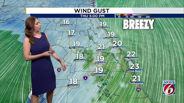
Behind the front, northeast winds will pick up to 10–15 mph, with gusts around 20–25 mph, especially along the coast as high pressure builds to the north.
Temperatures will hold near normal, reaching the low to mid-80s inland and upper 70s along the coast.
Thursday morning, wake-up temperatures will dip into the upper 50s to low 60s inland, and the mid- to upper 60s along the coast.
[VIDEO BELOW: Gotha family finds bear on porch]
Friday through Saturday
High pressure over the Southeast will keep the weather mostly dry and stable. The main weather story will be the windy conditions, with gusts at 25–30 mph, especially along the beaches. Winds will be strongest during the afternoons and ease slightly overnight, but breezy conditions will continue through the weekend.
Temperatures stay seasonable, with highs in the low 80s and overnight lows in the 60s to low 70s.
Marine Hazards
Beach and boating conditions will deteriorate. A high risk of rip currents and rough surf is expected by Saturday. High surf advisories and minor beach erosion could develop around high tide, particularly near and south of Cape Canaveral.
Sunday through Next Week
There’s still some uncertainty about the track of Tropical Storm Melissa, but the latest guidance keeps it well south and east of Florida through next week.
A breezy onshore flow will continue, bringing 20–40% rain chances from Sunday into early next week as moisture increases.
[BELOW: Candace Campos tracks the tropics]
Halloween Preview
Models are latching on to the chance of a stronger front reaching us later in the week.
If models verify, the coolest air of the season will arrive, bringing highs into the 70s by Halloween and lows dipping into the upper 50s to low 60s by trick-or-treat time.
Daily Forecast
The News 6 Weather team ensures you’re always on top of the day’s weather.
Copyright 2025 by WKMG ClickOrlando – All rights reserved.