
It will be a foggy and muggy start to Saturday morning in Central Florida.The WESH 2 First Warning Weather Team says a shield of rain will move across the area this morning, mainly from Orlando southward, and is expected to continue through much of the morning.Meteorologist Cam Tran is also tracking thunderstorms in Osceola and Brevard counties, but none are expected to become strong or severe.As a cold front continues to push through the region Saturday, a few additional storms could develop this afternoon as daytime heating builds.Rain is expected to move out of the area by Sunday, though there will still be a slight chance for showers along the Central Florida coastline.Conditions turn dry Monday and Tuesday, but rainy weather is forecast to return Wednesday through Friday.There will be no major temperature swings behind this front. First Warning WeatherStay with WESH 2 online and on-air for the most accurate Central Florida weather forecast.RadarSevere Weather AlertsDownload the WESH 2 News app to get the most up-to-date weather alerts.The First Warning Weather team includes First Warning Chief Meteorologist Tony Mainolfi, Eric Burris, Marquise Meda and Cam Tran.What is Impact Weather?Impact Weather suggests weather conditions could be disruptive or a nuisance for travel and day-to-day activities.What is a Severe Weather Warning Day?A Severe Weather Warning Day suggests weather conditions that could potentially harm life or property.DOWNLOAD the free WESH 2 News app for your latest news and alerts on breaking news, weather, sports, entertainment and more on your phone or tablet. And check out the Very Local app to stream news, entertainment and original programming on your TV.
ORLANDO, Fla. —
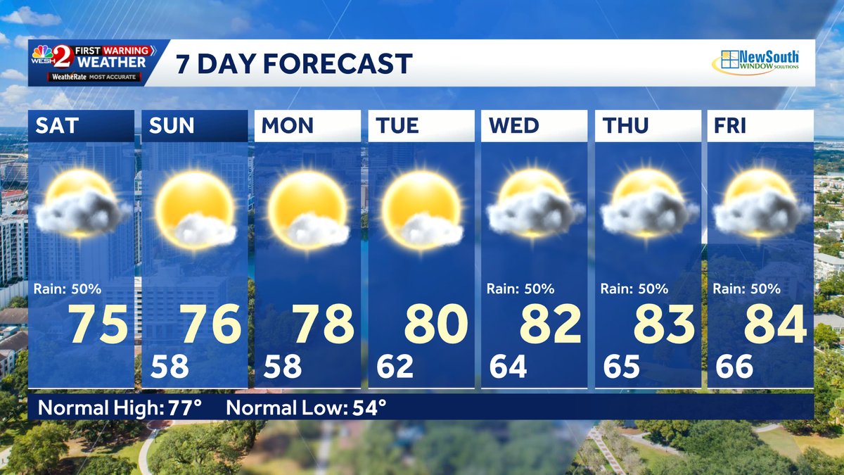
It will be a foggy and muggy start to Saturday morning in Central Florida.
The WESH 2 First Warning Weather Team says a shield of rain will move across the area this morning, mainly from Orlando southward, and is expected to continue through much of the morning.
Meteorologist Cam Tran is also tracking thunderstorms in Osceola and Brevard counties, but none are expected to become strong or severe.
This content is imported from Twitter.
You may be able to find the same content in another format, or you may be able to find more information, at their web site.
As a cold front continues to push through the region Saturday, a few additional storms could develop this afternoon as daytime heating builds.

Rain is expected to move out of the area by Sunday, though there will still be a slight chance for showers along the Central Florida coastline.
Conditions turn dry Monday and Tuesday, but rainy weather is forecast to return Wednesday through Friday.
There will be no major temperature swings behind this front.
First Warning Weather
Stay with WESH 2 online and on-air for the most accurate Central Florida weather forecast.
Download the WESH 2 News app to get the most up-to-date weather alerts.
The First Warning Weather team includes First Warning Chief Meteorologist Tony Mainolfi, Eric Burris, Marquise Meda and Cam Tran.
What is Impact Weather?
Impact Weather suggests weather conditions could be disruptive or a nuisance for travel and day-to-day activities.
What is a Severe Weather Warning Day?
A Severe Weather Warning Day suggests weather conditions that could potentially harm life or property.
DOWNLOAD the free WESH 2 News app for your latest news and alerts on breaking news, weather, sports, entertainment and more on your phone or tablet. And check out the Very Local app to stream news, entertainment and original programming on your TV.