
Cold front to bring scattered showers and storms across South Florida
OVER TO OUR AREA. RIGHT NOW WE ARE DEALING WITH SOME WEATHER CHANGES. SANDRA BIG TIME. WE DESPERATELY NEED THE RAIN AND WE’RE ACTUALLY SEEING SOME OF THAT ACTION THIS MORNING AS SOME DOWNPOURS ARE MOVING THROUGH. SO IMPACT WEATHER TODAY FOR SHOWERS AND EVEN MAYBE AN ISOLATED STRONG TO SEVERE STORM. RIGHT NOW IT’S RAINING IN VERO BEACH A SIGHT FOR SORE EYES. FORT PIERCE YOU’RE GETTING DOWNPOURS AS WELL AS FORT DRUM AND OKEECHOBEE. NO LIGHTNING ASSOCIATED WITH THIS RIGHT NOW, BUT JUST SOME PRETTY GOOD BATCHES OF HEAVY RAIN. AND IT’S BEEN RAINING HERE EVER SINCE I CAME IN ABOUT AN HOUR AGO. SO FROM INDIAN RIVER SHORES INTO VERO, THEIR DOWNPOURS, FLORIDA RIDGE, SAINT LUCIE, VILLAGE, FORT PIERCE, CORTEZ ESTATES, COLLIN PARK ESTATES IF WE’RE STREET LEVEL TRACKING ALONG 95 BACK TOWARD THE LAKE, WE HAVE RAINS AS WELL. RAINS REALLY INUNDATING FORT DRUM, NIKO MIKKOLA AND DOWN INTO OKEECHOBEE. SO THIS IS REALLY A GOOD THING. IT’S A FRONT THAT’S MOVING THROUGH AND AS IT DOES SO, IT’S GENERATING THE RAIN. SO WE DON’T NEED STRONG TO SEVERE STORMS EVERY. BUT WE ARE IN THAT LOWEST LEVEL OR MARGINAL OR ISOLATED RISK FOR THAT. THIS AFTERNOON SOMETIME ABOUT 2:00 ONWARD, I THINK WE HAVE THE HIGHEST RISK FOR SEEING A COUPLE OF ISOLATED, STRONG TO SEVERE STORMS. I’LL HAVE YOUR FUTURE TRACKS AHEAD IN THE NEWSCAST, BUT FIRST, TEMPERATURES YOU’RE WAKING UP TO ARE MILD AND IT’S MUGGIER OUT THERE. MAYBE EVEN SOME PATCHY, DENSE FOG. KEEP YOUR EYES OUT FOR THAT THIS MORNING. WE’VE GOT THE IMPACT WITH THE DOWNPOURS AROUND THE TREASURE COAST REALLY PEAKING THIS AFTERNOON. SO THAT’S WHEN THE IMPACT LEVEL REALLY GOES UP FROM ABOUT NOON ONWARD THROUGH 6 P.M. AND THEN WE’RE GOING TO SEE THAT GOOD COVERAGE OF STORMS FINALLY DISSIPATE AFTER ABOUT SEVEN, 8:00 TONIGHT FOR THE PALM BEACHES. TAKING A LIVE LOOK OUT HERE. IT IS DRY IN PALM BEACH GARDENS, BUT WE HAVE THE IMPACT FOR THE STORMS REALLY STARTING TO MATERIALIZE. ABOUT 1:00 ONWARD THROUGHOUT THE EARLY EVENING HERE AS WELL. AHEAD, WE’LL TAKE A LOOK AT YOU
Cold front to bring scattered showers and storms across South Florida

Updated: 8:42 AM EST Feb 28, 2026
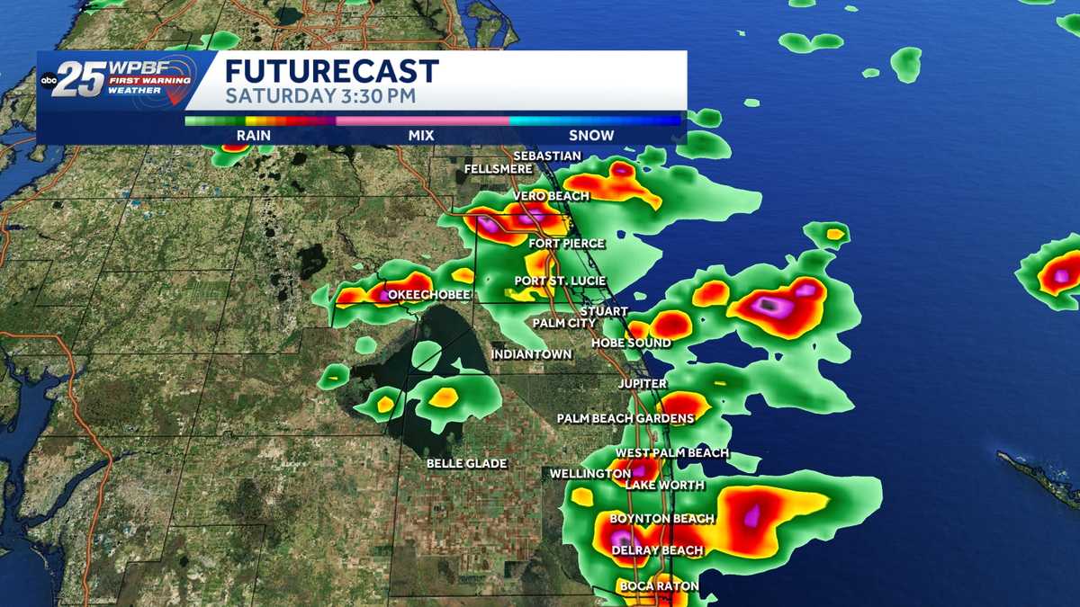
The WPBF 25 First Warning Weather team is tracking impact weather with strong storms across South Florida. A cold front begins to dip in bringing isolated showers and storms to South Florida Saturday morning. Interactive radar: South Florida weather coverage from WPBF 25 NewsCoverage increases to scattered into the afternoon with activity hanging around through the evening. What to expect:Timing: 1 p.m. to 7 p.m. Threats: Gusty winds 50 mph, small hail and funnel clouds Highs will stay in the lower 80s. Temperatures will not take a hit after the front slides through. Get the latest weather updates with the WPBF 25 News app. You can download it here.
The WPBF 25 First Warning Weather team is tracking impact weather with strong storms across South Florida.
A cold front begins to dip in bringing isolated showers and storms to South Florida Saturday morning.
Interactive radar: South Florida weather coverage from WPBF 25 News
Coverage increases to scattered into the afternoon with activity hanging around through the evening.
What to expect:
Timing: 1 p.m. to 7 p.m. Threats: Gusty winds 50 mph, small hail and funnel clouds


Highs will stay in the lower 80s. Temperatures will not take a hit after the front slides through.
Get the latest weather updates with the WPBF 25 News app. You can download it here.