
Heating Up In Central Florida Throughout the First Week of March – Small Rain Chances Next Weekend
Heating Up In Central Florida Throughout the First Week of March – Small Rain Chances Next Weekend
GAME TONIGHT. THE MATCH BEGINS AT SEVEN. FIRST WARNING METEOROLOGIST MARQUISE MEDA HERE. NOW MARQUISE THEY’RE GETTING SOME GOOD WEATHER FOR IT TOO. IT SEEMS LIKE EVERYTHING’S KIND OF MOVED OUT JUST IN TIME. IT’S A FABULOUS FINISH TO THE WEEKEND, JESSE. WE HAVE THOSE SHOWERS TO START IT OFF ON SATURDAY. A FEW MORE ALONG THE COAST YESTERDAY, BUT TODAY WE’VE BEEN TRENDING DRY. OUR RADAR PRETTY CLEAR. WE’VE SEEN SUNSHINE STRETCH FROM END TO END, FROM I-75 TO I-95 HERE IN CENTRAL FLORIDA. ALSO, WE’VE GOT SOME WARMER WEATHER HAPPENING THIS WEEK AS WE MOVE THROUGHOUT IT. WE CONTINUE TO RAISE THE BAR HERE IN CENTRAL FLORIDA. UPPER 70S ON MONDAY. IF YOU’RE INLAND, YOU’LL HIT THE 80S BY TUESDAY, AND THEN BY THE TIME THE WORKWEEK COMES TO ITS CLOSE, YOU’RE BACK IN THE MID 80S. SO IT FEELS LIKE DAY AFTER DAY WE’RE ONLY GETTING WARMER AND WARMER. HERE’S A LOOK AT YOUR HIGHS FOR TODAY. SOME OF US CAME REALLY CLOSE TO THE 80S. THOSE INCLUDING US RIGHT HERE INSIDE THE CITY. BEAUTIFUL. 79 DEGREES WAS YOUR HIGH IN ORLANDO, 78 IN BITHLO. THE FURTHER SOUTH YOU GO. LOOKS LIKE THE WARMER TEMPERATURES WERE 81. WAS YOUR HIGH TODAY IN WINTER HAVEN? LET’S GET YOU OUT TO ORLANDO RIGHT NOW. YOU’VE COOLED SINCE YOUR MAXIMUM DAYTIME HEATING HOURS. GOT A COUPLE EXTRA CLOUDS IN THE PICTURE AS THE SUN BEGINS TO SET. RIGHT NOW YOU’RE SITTING COMFORTABLY AT 72 DEGREES ELSEWHERE. AS YOU HEAD FURTHER NORTH AND TOWARDS THE EAST. THAT’S WHERE YOU’RE A TOUCH COOLER ACROSS I-95. PALM COAST 61, DAYTONA BEACH 63. AND YOU MATCH THAT IN NEW SMYRNA BEACH CURRENTLY OUT THE DOOR RIGHT NOW. NOT TOO MUCH TO LOOK AT. AND THAT’S A GOOD THING HERE IN CENTRAL FLORIDA, WE SAW A LOT MORE RAIN SHOWERS YESTERDAY. IN FACT YOU’RE STILL DEALING WITH THESE ACROSS SOUTHERN FLORIDA WITH A COLD FRONT MARCH ACROSS OUR SUNSHINE STATE OVER THE COURSE OF THE WEEKEND. NOW, THOUGH, IT’S ANOTHER FRONTAL BOUNDARY KNOCKING ON OUR FRONT DOORSTEP, MOVING JUST NORTH OF THE I-10 CORRIDOR. IT WON’T GET TO US HERE IN FLORIDA, SO THAT WILL GIVE US TIME FOR THESE TEMPERATURES TO RISE. BUT WE ALSO HAVE A FALCON NINE LAUNCH TAKING PLACE TONIGHT. LAUNCH WINDOW STARTS AT 707. JUST A COUPLE CUMULUS CLOUDS ACROSS THE COAST. SO NOTHING REALLY THAT’S REALLY GOING TO STOP THIS LAUNCH. ULTIMATELY, IT’S A 90% CHANCE THAT WE’LL BE GREEN TO GO. ULTIMATELY, THOUGH, BY MONDAY. TAKE A LOOK AT THIS. WE WILL SEE A LOT MORE SUNSHINE IN THE PICTURE AS WE ROLL THROUGHOUT THE WORKWEEK. HIGHS WILL RETURN TO THE UPPER 70S AND LOWER 80S. SO WE’LL BE TRENDING DRY AS WE MOVE INTO THE START OF YOUR WORKWEEK TOMORROW. SO 69 TO 81 DEGREES. THAT’S OUR TEMPERATURE SPREAD A LITTLE BIT COOLER AS YOU MOVE ACROSS FLAGLER COUNTY, LIKELY IN PALM COAST. THAT’S WHERE WE HAVE THE UPPER 60S. BREEZY TO START THINGS OFF DRY ON MONDAY, AS I MENTIONED, BUT WE’LL WELCOME THE CHANCE FOR SOME COASTAL SHOWERS TUESDAY INTO WEDNESDAY. FOLLOW. THESE WINDS ARE COMING IN FROM THE EAST COAST NOW. WITH THAT, SEA BREEZE WILL PICK UP THE EXTRA MOISTURE. AND THAT’S WHAT’S ALLOWING FOR THOSE SPOTTY CHANCES FOR SHOWERS. BUT ALSO HAPPENING THIS WEEK. WE DO HAVE A LUNAR ECLIPSE TAKING PLACE THAT IS COMING UP ON TUESDAY IN THE MORNING. SO MARCH 3RD, JUST TWO DAYS FROM NOW. ECLIPSE WINDOW DOES BEGIN AT 344 IN THE MORNING AND JUST AFTER SUNRISE, TEMPERATURES STILL HANGING AROUND THE LOWER 60S. SO IF YOU’RE GOING OUT TO GO VIEW, JUST MAKE SURE THAT YOU DO BRING THE LIGHTWEIGHT JACKET. YOU WON’T NEED IT LATER ON IN THE AFTERNOON, AS TEMPERATURES SHOULD BE RETURNING TO THE 80S AS WE HEAT UP ON THE FIRST AND ALSO THE SECOND WEEK OF MARCH. I MENTIONED WE HAVE A FEW SPOTTY RAIN CHANCES COMING OUR DIRECTION OVER THE COURSE OF THE NEXT WEEK. WE’RE GOING TO SEE MAYBE HALF OF AN INCH OF RAIN IF WE’RE LUCKY. SO ISOLATED SHOWERS ARE GOING TO BE IN THE PICTURE. AND HERE’S HOW YOUR TEMPERATURES SPREAD IS GOING TO STACK UP. UPPER 70S TOMORROW. LOWER 80S ON TUESDAY. WE HOLD ON TO THAT SUNSHINE. WEDNESDAY AND THURSDAY. YOU SEE THOSE RAI
Heating Up In Central Florida Throughout the First Week of March – Small Rain Chances Next Weekend
Heating Up In Central Florida Throughout the First Week of March – Small Rain Chances Next Weekend

Updated: 6:43 PM EST Mar 1, 2026
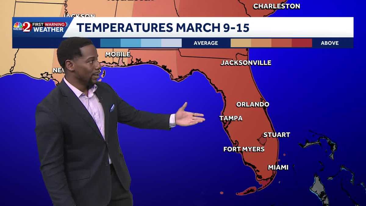
Heating Up In Central Florida Throughout the First Week of March – Small Rain Chances Next WeekendSunshine was back this afternoon, allowing for a great finish to your weekend here in Central Florida. Highs returned to the mid and upperr seventies this today, and under mostly clear conditions we’ll cool into the sixties tonight.Starting Monday, we begin a warming trend that really takes off through the week. Highs climb from the upper 70s and low 80s early, then into the mid to upper 80s by next weekend running 5 to 10 degrees above normal.By Tuesday and beyond, increasing Atlantic moisture and steady onshore winds will bring a better chance for scattered coastal showers, with a few storms possible during the afternoons. Most activity stays near the coast and pushes inland with the sea breeze.
Heating Up In Central Florida Throughout the First Week of March – Small Rain Chances Next Weekend
Sunshine was back this afternoon, allowing for a great finish to your weekend here in Central Florida. Highs returned to the mid and upperr seventies this today, and under mostly clear conditions we’ll cool into the sixties tonight.Starting Monday, we begin a warming trend that really takes off through the week. Highs climb from the upper 70s and low 80s early, then into the mid to upper 80s by next weekend running 5 to 10 degrees above normal.By Tuesday and beyond, increasing Atlantic moisture and steady onshore winds will bring a better chance for scattered coastal showers, with a few storms possible during the afternoons. Most activity stays near the coast and pushes inland with the sea breeze.