
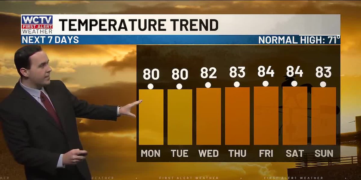
TALLAHASSEE, Fla. (WCTV) – Temperatures stay around 10º above average to start the work week.
Tonight Through Monday Night
Quiet weather will continue across the region to end the weekend. Lows settle in the mid-and-upper-40s under a mostly clear sky. Again, some patchy fog is possible.
After some morning fog, we are expecting another mostly sunny, warm day to start the work week. Highs on Monday climb into the upper-70s and low-80s.
We are dry for Monday night under a mostly clear sky. Dense fog will be possible as lows bottom out in the mid-50s.
Middle Of The Week
Tuesday is looking dry, mostly sunny and warm. Temperatures reach the upper-70s and low-80s. Lows fall into the mid-50s.
A stray sprinkle is possible on Wednesday, but most of us are dry under a mix of Sun and clouds. Temperatures hover in the low-80s, with lows in the upper-50s and low-60s.
Ending The Week
The weather pattern is looking mostly dry and warm to end the work week.
Highs on Thursday top out in the low-80s under a partly cloudy sky. An isolated shower is possible, but it will not rain for everyone. Lows bottom out in the upper-50s and low-60s.
Another warm day is ahead for Friday. Highs reach the low-and-mid-80s under a mix of Sun and clouds. A stray shower is possible, but most are looking dry. Overnight lows settle in the upper-50s and low-60s.
To stay updated on all the latest forecasts and weather, follow WCTV First Alert Weather on Facebook and X (Twitter).
Click here to see all the latest weather headlines and here to view the First Alert Radar. Receive push alerts and watch the latest forecast anytime on the free WCTV First Alert Weather app. Click here to download it now.
Interested in becoming a WCTV First Alert Weather Watcher? Click here to join the team!
Copyright 2026 WCTV. All rights reserved.