
JACKSONVILLE, Fla. — Dense fog is impacting northeast Florida this morning with widespread low visibilities less than 0.25 miles. A Dense Fog Advisory runs through 9 a.m.
Visibilities are much better along the I-75 corridor and in inland southeast Georgia.Some sea fog may linger along the immediate oceanfront through much of today.Temperatures will rise into the middle and upper 70s inland this afternoon, with gusty onshore winds keeping beaches in the 60s. It will be a dry day.Another round of fog is possible tonight/early Tuesday morning, which would limit visibility of Tuesday morning’s total lunar eclipse.An isolated shower or two is possible Tuesday and Wednesday with the onshore wind continuing, otherwise temperatures will be similar in the 70s inland/60s along the coast.Most communities will stay completely dry this week.A warming trend continues into the weekend with highs rising into the lower and middle 80s.The Gate River Run Saturday looks dry, mild, and somewhat humid with warming temperatures into the 70s by mid-morning.
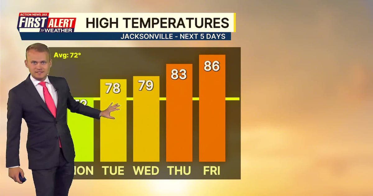
TODAY: Morning fog, afternoon sun. HIGH: 72 (60s at the beaches)
TONIGHT: Fog developing late. LOW: 54
TUESDAY: Morning fog, afternoon sun, isolated shower. 54/78 (60s at the beaches)
WEDNESDAY: Partly cloudy and mild, isolated shower. 57/79
THURSDAY: Partly cloudy and warmer. 59/83 (Record: 87 – 2020)
FRIDAY: Partly cloudy. 61/86 (Record: 88 – 1961)
SATURDAY: Partly cloudy. 62/83
SUNDAY: Partly cloudy. 62/84 (Record: 86 – 1974)
WATCH THE FORECAST | DOWNLOAD THE APPS
Follow Action News Jax Meteorologists on Twitter for updates:
Mike Buresh | Garrett Bedenbaugh | Corey Simma | Trevor Gibbs
ALLERGY TRACKER: See what the pollen counts look like in our area
LISTEN: Mike Buresh ‘All the Weather, All the Time’ Podcast
INTERACTIVE RADAR: Keep track of the rain as it moves through your neighborhood
SHARE WITH US: Send us photos of the weather you’re seeing in your area ⬇️