
ORLANDO, Fla. – Warm, breezy conditions will stick around across Central Florida this week, bringing a little bit of everything to the forecast, including patchy fog, spotty afternoon showers, building heat, and dangerous beach conditions.
And with Bike Week underway in Daytona Beach, many visitors and locals alike are watching the sky closely.
Late Tuesday into early Wednesday morning, patchy fog could develop, especially along and north of the I-4 corridor. That includes parts of the Orlando metro, Sanford, and areas in Volusia County.
Some of that fog could become locally dense, reducing visibility to less than a mile in spots for the Wednesday morning drive to work and school. It is not a guarantee, as winds need to relax just enough, but conditions are favorable enough to plan for if you are heading out early.
Tuesday afternoon, we have seen isolated to scattered showers develop as moisture moves in off the Atlantic.
[RELATED: Bike Week kicks off in Daytona Beach]
The good news for Bike Week visitors is that most of Tuesday’s showers have stayed well south of Daytona Beach, focusing more on Orlando south toward Osceola County and Lake Okeechobee.
Rain chances (Copyright 2026 by WKMG ClickOrlando – All rights reserved.)
Rainfall has generally been light, a tenth of an inch or less in most neighborhoods, though a few heavier pockets briefly picked up closer to a quarter inch or slightly more. A stray lightning strike cannot be completely ruled out, but overall storm chances remain very low.
This general pattern continues through early next week. Expect isolated to scattered showers to develop over the Atlantic and then push inland during the afternoon hours, with the highest rain chances inland.
Beginning Thursday, there will be a low chance of lightning storms, generally 20 percent or less. Rain chances increase slightly on Thursday through Saturday, but we are not looking at washout days, including for Bike Week events.
Many hours each day will stay dry. Through Monday night, most areas will pick up between a quarter and a half inch of rain, with isolated higher amounts where showers recur over the same locations.
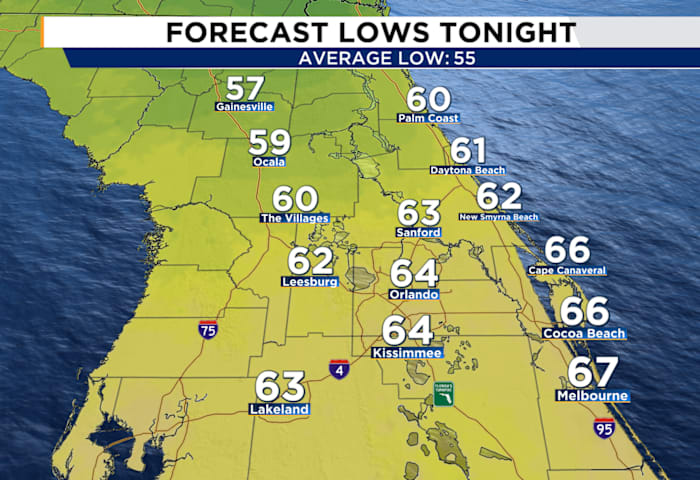
Temperatures will continue trending warmer as we move through the week. Afternoon highs climb from the upper 70s and low 80s midweek into the mid and upper 80s by late week and into the weekend. Inland areas could reach 85-87 degrees, well above normal for early March. Overnight lows will also stay mild, mostly in the 60s. It may feel more like late spring than early March.
While temperatures may be inviting for the beaches, surf conditions will not be. Persistent onshore winds are building swell and creating rough surf.
There is a high risk of life-threatening rip currents at all area beaches, and that risk is expected to continue through much of the week. If you are heading to the coast, including Daytona Beach for Bike Week, entering the surf is not advised.
Copyright 2026 by WKMG ClickOrlando – All rights reserved.