
Spring is in the forecast for Central Florida, in terms of temperatures and the chance for rain Thursday afternoon. Temps are expected to reach the 80s this afternoon. The chance for showers increases after the lunch hour, with widespread rain expected during the evening commute. The First Warning Weather Team says the heaviest concentration of showers on Thursday will be west of Interstate 4. Rainfall accumulation by the end of the day could exceed 1-2 inches. Rain chances continue all week. Hour-by-hour lookRain chances next several days Drought monitorThe rain is much welcomed after weeks of dry conditions across the region. Here’s an updated look at our drought monitor: Looking aheadFirst Warning Weather Stay with WESH 2 online and on-air for the most accurate Central Florida weather forecast.RadarSevere Weather AlertsDownload the WESH 2 News app to get the most up-to-date weather alerts. The First Warning Weather team includes First Warning Chief Meteorologist Tony Mainolfi, Eric Burris, Marquise Meda and Cam Tran.What is Impact Weather?Impact Weather suggests weather conditions could be disruptive or a nuisance for travel and day-to-day activities.What is a Severe Weather Warning Day?A Severe Weather Warning Day suggests weather conditions that could potentially harm life or property.
ORLANDO, Fla. —
Spring is in the forecast for Central Florida, in terms of temperatures and the chance for rain Thursday afternoon.
Temps are expected to reach the 80s this afternoon. The chance for showers increases after the lunch hour, with widespread rain expected during the evening commute.
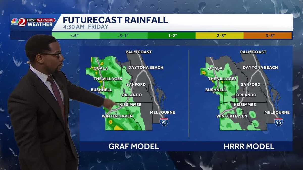
The First Warning Weather Team says the heaviest concentration of showers on Thursday will be west of Interstate 4.
Rainfall accumulation by the end of the day could exceed 1-2 inches.
Rain chances continue all week.
This content is imported from Twitter.
You may be able to find the same content in another format, or you may be able to find more information, at their web site.
Some much needed rain heads our way today and it will favor the western side of our viewing area. Here’s the latest on today’s rainfall chances across Central #florida. Stay with #weshwx for updates. pic.twitter.com/Ri26rYRwRT
— Tony Mainolfi (@TMainolfiWESH) March 5, 2026
Hour-by-hour look
This content is imported from Twitter.
You may be able to find the same content in another format, or you may be able to find more information, at their web site.
Rain chances next several days

WESH 2 News
Rain chances all week
Drought monitor
The rain is much welcomed after weeks of dry conditions across the region.
Here’s an updated look at our drought monitor:

WESH 2 News
Drought Monitor March 5, 2026
Looking ahead
This content is imported from Twitter.
You may be able to find the same content in another format, or you may be able to find more information, at their web site.
First Warning Weather
Stay with WESH 2 online and on-air for the most accurate Central Florida weather forecast.
Download the WESH 2 News app to get the most up-to-date weather alerts.
The First Warning Weather team includes First Warning Chief Meteorologist Tony Mainolfi, Eric Burris, Marquise Meda and Cam Tran.
What is Impact Weather?
Impact Weather suggests weather conditions could be disruptive or a nuisance for travel and day-to-day activities.
What is a Severe Weather Warning Day?
A Severe Weather Warning Day suggests weather conditions that could potentially harm life or property.