
Sea Breeze Collisions Spark Storms and Showers in Central Florida Following the Arnold Palmer Invitational
Sea Breeze Collisions Spark Storms and Showers in Central Florida Following the Arnold Palmer Invitational
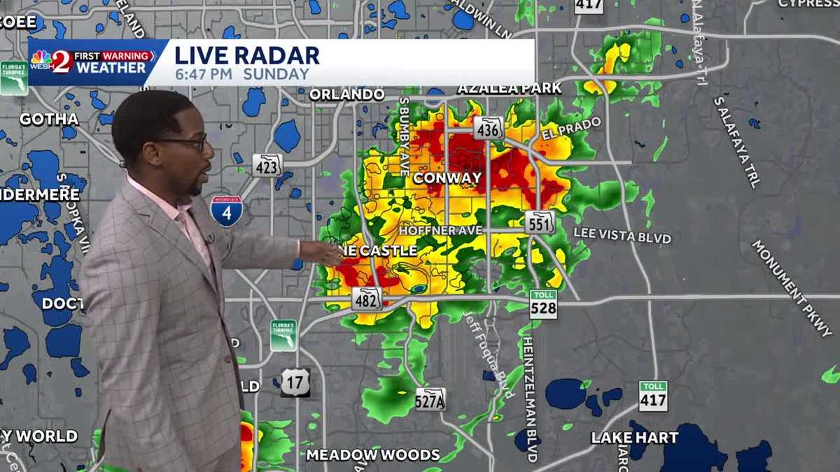
POLICE INVESTIGATE THE INCIDENT, THERE MAY BE MORE OFFICERS ON CAMPUS. ALL RIGHT, LET’S TALK ABOUT WHAT IS GOING ON WEATHER WISE OUTSIDE MARQUISE SOME GORGEOUS WEATHER OUT THERE THAT WE HAD TODAY. WARMER TEMPERATURES. EVEN THOUGH THINGS ARE CHANGING TONIGHT, IT FEELS SO COMFORTABLE TO START OFF THE AFTERNOON. I WALKED OUTSIDE AND I WAS LIKE, THIS IS WHERE I NEED TO BE. OUT IN THE SUNSHINE. WHAT AM I DOING? I’M INSIDE RIGHT NOW BECAUSE IT’S RAINING OUTSIDE HERE IN CENTRAL FLORIDA. GOT A COUPLE SHOWERS MOVING PAST THE METRO, BUT TAKE A LOOK AT THE TEMPERATURES WE SAW TODAY. SET A RECORD IN SANFORD WITH A HIGH OF 89 DEGREES. YOU WERE JUST A TOUCH COOLER IN ORLANDO. 88 WAS YOUR HIGH TODAY. BUT ACROSS THE I-4 CORRIDOR YOU’RE WELL ABOVE YOUR SEASONAL AVERAGE. 85 FOR DAYTONA BEACH, WAY DOWN SOUTH AT WINTER HAVEN, YOU GUYS HIT 87 DEGREES TODAY AND WE’VE GOT SOME SPRING LIKE WARMTH TO KICK OFF YOUR WORK. WEEK 87 TOMORROW. ON MONDAY IN ORLANDO, 88 TUESDAY. AND WE JUST KEEP RAISING THE BAR. BY WEDNESDAY WE’LL HIT 89 DEGREES TEMPERATURES YET AGAIN IN ORLANDO. RIGHT NOW WE’RE STARTING TO LOOK AT THE SHOWERS COMING IN. LOOKS LIKE THEY’RE RIGHT BEHIND OUR OUR TEMPERATURES. BUT WE SHOW 85 DEGREES. SO THESE SHOWERS MOVING EAST OUT TOWARDS THE WESTERN SIDE OF YOUR SCREEN. BLUE SKIES OUT TOWARDS THE EAST. THAT’S WHERE WE HAVE THOSE DOWNPOURS. AND WE CAN SEE A LITTLE BIT BETTER ON RADAR HERE. CONTINUING TO PUSH PAST THE I-4 CORRIDOR WAY UP NORTH THOUGH IN PALM COAST, THIS IS WHAT WE’RE CHECKING OUT. SOME OF OUR STRONGER STORMS FROM SHELL BLUFF THROUGH PALM COAST. LIGHTNING STRIKES ONGOING WITH THOSE SHOWERS THERE. FURTHER TOWARDS THE SOUTH ACROSS SORRENTO. WE’RE WATCHING THAT BATCH OF RAIN COME TO AN END. BUT AS WE KEEP ON PUSHING SOUTH ACROSS THE I-4 CORRIDOR, THIS IS WHAT I WAS TRYING TO SHOW YOU ON THE TOWER CAM NETWORK ACROSS CONWAY PINE CASTLE, WE SEE A LOT OF HEAVY DOWNPOURS COURTESY OF A SEABREEZE COLLISION TAKING PLACE. YOU SEE THAT DOMINANT FLOW COMING IN FROM THE WEST. AND WHAT IT’S MEETING UP WITH IS THAT BOUNDARY FROM THE EAST COAST SEA BREEZE AS WELL. THAT SPAWNED SOME SHOWERS ACROSS DISNEY INTO CELEBRATION, THESE PUSHING TOWARDS THE NORTH AND THE EAST ACROSS SEAWORLD RIGHT NOW. FURTHER SOUTH INTO POLK COUNTY, WINTER HAVEN, BARTOW, LAKE WALES. YOU GUYS HAVE BEEN NO STRANGER TO THE RAIN THIS AFTERNOON. WE’VE SEEN A CLUSTER OF SHOWERS STILL ONGOING, AND IT’S PREDOMINANTLY THAT WEST COAST FLOW DIRECTING TRAFFIC TODAY, AND THAT WILL ALLOW FOR SOME SHOWERS ACROSS OUR COASTLINE BEFORE THE EVENING IS SAID AND DONE. COULD WALK AWAY WITH 1 TO 2 PLUS INCHES OF RAIN. SO STILL THROUGH 9:00, WE’RE TRYING OUR BEST TO SQUEEZE OUT THE LAST FEW ROUNDS OF RAIN. BY MIDNIGHT WE’RE MUCH DRIER, BUT WE WILL SEE SOME CHANCES FOR SOME FOGGY WEATHER OVERNIGHT. AS FAR AS RAINFALL ACCUMULATION IS CONCERNED, WE COULD SEE POCKETS OF 1 TO 2 PLUS INCHES ACROSS SOME OF OUR SOUTHERNMOST COMMUNITIES, AND THEY NEED IT ALL THROUGHOUT CENTRAL FLORIDA. WE ARE STILL SHOWING DRY WEATHER CONDITIONS FOR 2026. SO FAR WE’RE IN THAT DROUGHT. SOME OF US ARE IN EXTREME DROUGHT TONIGHT, THOUGH TEMPERATURES SHOULD RANGE ANYWHERE BETWEEN 62 AND 68 DEGREES. YOUR CHANCE FOR FALL WILL BE GREAT. IT’S THE FURTHER NORTH YOU GO TO START OFF THE DAY TOMORROW, BUT THAT FOG WILL QUICKLY LIFT. THIS TEMPERATURES ARE TRENDING WARM IN OCALA. YOU GUYS COULD HIT 90 DEGREES BY WEDNESDAY. THE HEAT IS ON ITS WAY, BUT WE ALSO HAVE A COLD FRONT THAT WILL KNOCK YOU BACK DOWN TO YOUR SEASONAL AVERAGE BY FRIDAY. SHOWERS COMING IN ON THURSDAY. A 60% COVERAGE. WE DROP DOWN TO 78 DEGREES FRIDAY AND THEN WE’RE WARM NEX
Sea Breeze Collisions Spark Storms and Showers in Central Florida Following the Arnold Palmer Invitational
Sea Breeze Collisions Spark Storms and Showers in Central Florida Following the Arnold Palmer Invitational

Updated: 8:04 PM EDT Mar 8, 2026
Sea Breeze Collisions Spark Storms and Showers in Central Florida Following the Arnold Palmer InvitationalSunshine and warm temperatures are building across Central Florida this afternoon, with highs already climbing into the low to mid 80s. Scattered showers are beginning to develop near the coast, and as the sea breeze pushes inland, storms are expected to increase later today. The best chance for scattered thunderstorms will be between 5 and 10 PM, mainly from the I-4 corridor southward, where a few storms could become strong with gusty winds and small hail. Any activity will gradually weaken before midnight. Looking ahead, above normal heat sticks around through midweek, with some inland cities approaching 90 degrees before a cold front brings better rain chances late Thursday. This will put an end to our warming trend dropping temps into a much more seasonal workweek finish I the upper seventies Friday.
Sea Breeze Collisions Spark Storms and Showers in Central Florida Following the Arnold Palmer Invitational
Sunshine and warm temperatures are building across Central Florida this afternoon, with highs already climbing into the low to mid 80s. Scattered showers are beginning to develop near the coast, and as the sea breeze pushes inland, storms are expected to increase later today. The best chance for scattered thunderstorms will be between 5 and 10 PM, mainly from the I-4 corridor southward, where a few storms could become strong with gusty winds and small hail. Any activity will gradually weaken before midnight.
Looking ahead, above normal heat sticks around through midweek, with some inland cities approaching 90 degrees before a cold front brings better rain chances late Thursday. This will put an end to our warming trend dropping temps into a much more seasonal workweek finish I the upper seventies Friday.