
Spring Breakers Beware, Showers & Storms Slide into Central Florida This Weekend Followed by a Sharp Temperature Drop by Midweek
Spring Breakers Beware, Showers & Storms Slide into Central Florida This Weekend Followed by a Sharp Temperature Drop by Midweek
SUMMER AND SPRING CAN MAKE THE PROBLEM EVEN WORSE. AND THE WEEKEND IS FINALLY HERE. SPRING BREAK ALREADY STARTED FOR A LOT OF STUDENTS ACROSS CENTRAL FLORIDA, AND WE ALSO HAVE. SPRING BREAKERS ARE COMING INTO TOWN. MARQUISE THEIR UMBRELLA. THE UMBRELLA WILL BE A NECESSARY ITEM, MAYBE EVEN A WINTER JACKET COME YOUR WAY ON WEDNESDAY TO START OFF THE MORNING TEMPERATURES WILL SHIFT INTO THE 40S IN THE 50S, AND YOUR AFTERNOON HIGHS WON’T BE TOO MUCH WARMER, DROPPING ALL THE WAY DOWN FROM THE 80S ON MONDAY TO THE 60S TUESDAY AND WEDNESDAY. TEMPERATURES DRIFTING AWAY AS THAT ROLLER COASTER TAKES A NOSEDIVE HERE IN CENTRAL FLORIDA, ALL THE WAY DOWN TO SOME WINTER TIME TEMPERATURES. AS WE’RE SEVEN DAYS AWAY FROM THE START OF THE SPRING SEASON. TODAY, THOUGH FAIRLY AVERAGE DAY HERE IN CENTRAL FLORIDA. CLOUDY ACROSS THE I-4 CORRIDOR, 74 DEGREES IS WHAT YOU’RE SHOWING CURRENTLY AT 617 IN ORLANDO. JUST A HOP, SKIP AND A JUMP ACROSS I-75 AND SHOW THE UPPER 70S ACROSS WILDWOOD AND THE VILLAGES LOWER 80S IN OCALA. SO THE FURTHER NORTH YOU WENT, WELL, THE MORE SUNSHINE YOU SAW TODAY. OPPOSITE TREND. AS YOU HEAD FURTHER SOUTH, YOU SAW CLOUDS AND RAIN SHOWERS OFF AND ON AGAIN. INTERMITTENT SHOWERS ARE PRESENT ACROSS SATELLITE BEACH IN MELBOURNE, ACROSS BREVARD COUNTY. ONCE YOU MOVE FURTHER OFF TOWARDS THE WEST. STILL DEALING WITH SOME SHOWERS IN POINCIANA FOR OSCEOLA COUNTY. SO THESE ARE LIGHT ROUNDS OF RAIN, NOT REALLY ACCUMULATING TO TOO MUCH, MAYBE A 10TH OF AN INCH IS WHAT YOU’LL WALK AWAY FROM THE DAY WITH. BUT ULTIMATELY ALL OF US WILL SHOW THOSE CLOUDS BACK IN THE PICTURE TONIGHT AS TEMPERATURES STAY WARM, WE’LL DROP DOWN TO 68 DEGREES OVERNIGHT LOWS IN ORLANDO, AND WE WILL STILL SEE A CHANCE FOR MAYBE A STRAY SHOWER ACROSS THE I-4 CORRIDOR. ONCE YOU MOVE INTO POLK COUNTY OVERNIGHT. ULTIMATELY, THOUGH, AS WE HEAD INTO THE MORNING TOMORROW, THE FURTHER NORTH YOU GO, THE BETTER YOUR CHANCE FOR A LITTLE BIT OF SUNSHINE OUT THE DOOR. BUT EVENTUALLY THE RAIN WILL BE MAKING ITS RETURN SATURDAY, SUNDAY AND MONDAY. STILL TO COME MONDAY. THE SOGGIEST OF YOUR DAYS THAT LIE IN FRONT OF US AS WE WATCH A COLD FRONT MOVE IN. YOUR CHANCE FOR SHOWERS AND STORMS WILL BE MOVING ON UP AND EVENTUALLY YOUR WARMER TEMPERATURES WILL BE WILL BE MOVING OUT. TEMPERATURE WISE THOUGH, TOMORROW WE SHOULD BE PEAKING IN THE UPPER 70S AND LOWER 80S. SIMILAR TO THE HIGHS WE SAW TODAY, BUT WILL BE A LOT SOGGIER IN THE AFTERNOON. TRACKING ABOUT A 40% COVERAGE OF SHOWERS AND STORMS AS A WARM MASS OF AIR STARTS TO FILTER IN FROM THE SOUTH. WE’LL SEE THE RAIN SHOWERS COMING IN FROM THAT SAME DIRECTION. BETTER CHANCE FOR SOME STORMY WEATHER THOUGH, WITH A BIT OF AN EAST COAST SEA BREEZE MEETING UP WITH THAT WARM BOUNDARY FROM THE SOUTH, THAT COULD LEAD TO MAYBE A STRONG STORM OR TWO IN THE AFTERNOON. ON SUNDAY, 12 TO 1:00, WE SAW THAT IN TITUSVILLE. AND THEN AS WE HEAD TOWARDS THE 3:00 HOUR, LOOKS LIKE THE CHANCE FOR RAIN A LITTLE BIT MORE WIDESPREAD ACROSS THE I-4 CORRIDOR. ULTIMATELY, THOUGH, AS WE ENTER THE EVENING, YOUR CHANCE FOR SHOWERS WILL BE WASHING AWAY AND WE’LL BE LEFT WITH WARM TEMPERATURES HEADING INTO SUNDAY MORNING. BACK IN THE UPPER 60S AND LOW 70S. FOR SOME OF US, THE CULPRIT BEING THE STATIONARY BOUNDARY, IT STARTS OFF STATIONARY, BUT NOW IT STARTS TO LIFT TOWARDS THE NORTH. WE’LL SEE THAT MOISTURE BUILD ALL ACROSS OUR SUNSHINE STATE THIS WEEKEND, AND WE’LL FOLLOW THAT WITH A COLD FRONT MOVING IN ON MONDAY. THAT WILL TAKE YOU FROM THE MID 80S ON SUNDAY IN THE AFTERNOON, AND THAT WILL DROP YOU ALL THE WAY DOWN INTO THE 60S BY TUESDAY. SO ONCE THIS FRONT PASSES WILL BE MUCH DRIER HEADING INTO THE MIDDLE OF THE WORKWEEK. ALSO MUCH COOLER BEFORE WE GET THERE THOUGH, RAIN SHOWERS COULD ACCUMULATE ANYWHERE BETWEEN 1 TO 2IN ALONG THE I-4 CORRIDOR. AS YOU HEAD TOWARDS THE COAST. THIS PARTICULAR MODEL IS INDICATING 2 TO 3IN IN PLACES LIKE BITHLO, TITUSVILLE, PARTS OF BREVARD COUNTY. SO WE DESPERATELY NEED THE RAIN. ALL OF US ARE IN SOME FORM OF DROUGHT. THAT DROUGHT BECOMES A LOT MORE EXTREME UP NORTH, SO THEY NEED SHOWERS MORE THAN ANYBODY OUT THAT DIRECTION. RAIN COMES TO AN END ON MONDAY. TUESDAY, SUNSHINE RETURNS, BUT THE HEAT IS LONG GONE.
Spring Breakers Beware, Showers & Storms Slide into Central Florida This Weekend Followed by a Sharp Temperature Drop by Midweek
Spring Breakers Beware, Showers & Storms Slide into Central Florida This Weekend Followed by a Sharp Temperature Drop by Midweek

Updated: 7:00 PM EDT Mar 13, 2026
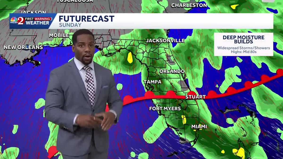
Spring Breakers Beware, Showers and Storms Slide into Central Florida This Weekend Followed by a Sharp Temperature Drop by MidweekSeasonal weather was back in the picture this afternoon as highs struggled to make it out of the seventies today. Most areas will stay dry as we wrap up the workweek, but there is a chance for a few brief showers south of I-4. Expect breezy onshore winds, keeping Rip Current Conditions high through the weekend.Also, this weekend, deeper moisture returns, bringing scattered showers and thunderstorms through Monday. A few storms could become strong, producing gusty winds, locally heavy rain, especially along the coast.To start the workweek a cold front arrives late Monday, pushing through the state and bringing a sharp temperature drop. Highs that reach the mid-80s Monday will fall into the 60s and low 70s by Tuesday, with bitter winter morning lows in the 50s and 40s by Wednesday.Bottom Line – Drier today, Showers Return this Weekend | Cold Front Moves in Monday
Spring Breakers Beware, Showers and Storms Slide into Central Florida This Weekend Followed by a Sharp Temperature Drop by Midweek
Seasonal weather was back in the picture this afternoon as highs struggled to make it out of the seventies today. Most areas will stay dry as we wrap up the workweek, but there is a chance for a few brief showers south of I-4. Expect breezy onshore winds, keeping Rip Current Conditions high through the weekend.Also, this weekend, deeper moisture returns, bringing scattered showers and thunderstorms through Monday. A few storms could become strong, producing gusty winds, locally heavy rain, especially along the coast.To start the workweek a cold front arrives late Monday, pushing through the state and bringing a sharp temperature drop. Highs that reach the mid-80s Monday will fall into the 60s and low 70s by Tuesday, with bitter winter morning lows in the 50s and 40s by Wednesday.
Bottom Line – Drier today, Showers Return this Weekend | Cold Front Moves in Monday