
TALLAHASSEE, Fla. (WCTV) – Showers and thunderstorms return to the region, and some could be strong to severe.
Tonight Through Monday Night
A cold front will approach the Big Bend and South Georgia Sunday night and Monday morning. This weather system will bring showers and storms, and some could pack a punch.
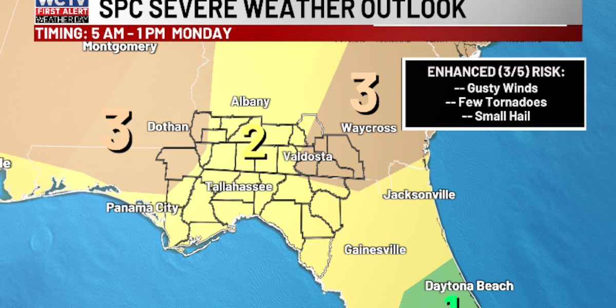
A Level 2 Slight risk of severe weather is in place for most of us. However, a Level 3 Enhanced risk is in place for the I-75 corridor and near Lake Seminole.
In terms of timing, the main severe weather threat should be between 5 a.m. and 1 p.m. Passing showers and storms are possible before 5 a.m., but the bulk of the strong storm activity should be in that timeframe.
In terms of threats, all modes of severe weather are on the table. The main threat will be strong, straight-line winds, but we could see a few tornadoes and small hail.
The higher tornado threat will come from discrete storms ahead of the main front. If these storms develop, a strong tornado or two cannot be ruled out.
The severe weather threat should come to an end by Monday afternoon. We stay breezy behind the front. We could see winds up to 25-30 mph.
Temperatures ahead of the front top out in the low-70s, but we quickly fall into the 50s and 60s during the afternoon.
A cold Monday night is ahead under a partly cloudy sky. Lows tumble into the mid-and-upper-30s. However, once you factor in the wind, we could see the wind chill in the low-30s to upper-20s.
A Quick Fight With Winter
St. Patrick’s Day is looking chilly and dry. Highs only top out in the mid-to-upper-50s under a mix of Sun and clouds. Lows tumble into the low-30s. Be sure to protect your plants as we could see some frost.
After a cold start, we should begin to warm by Wednesday afternoon. Temperatures reach the mid-60s under a partly sunny sky. Lows settle in the upper-30s.
Extended Forecast
The weather pattern is looking dry to end the week.
Highs on Thursday and Friday climb into the low-and-mid-70s under some sunshine.
Lows bottom out in the 30s and 40s.
To stay updated on all the latest forecasts and weather, follow WCTV First Alert Weather on Facebook and X (Twitter).
Click here to see all the latest weather headlines and here to view the First Alert Radar. Receive push alerts and watch the latest forecast anytime on the free WCTV First Alert Weather app. Click here to download it now.
Interested in becoming a WCTV First Alert Weather Watcher? Click here to join the team!
Copyright 2026 WCTV. All rights reserved.