
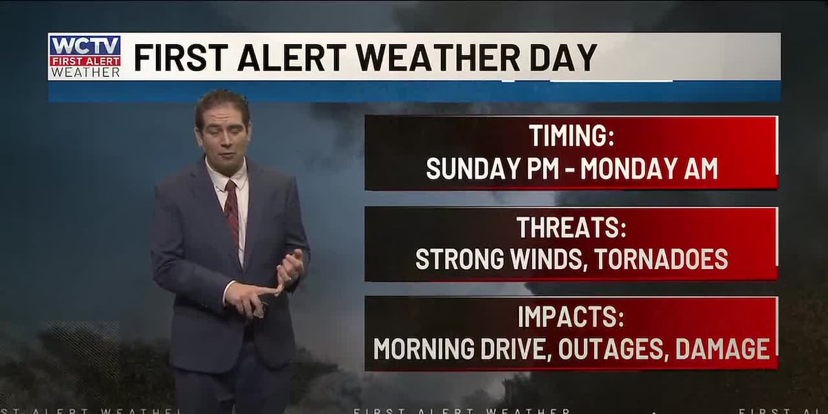
TALLAHASSEE, Fla. (WCTV) – A powerful cold front will bring strong storms and BIG changes to the area this week. Here is a detailed breakdown of the severe risk and First Alert Weather Day.
Still warm, isolated shower on Sunday
Rain moved through the eastern Big Bend this morning. There is about a 30% chance of rain for the next hour or so, then the skies will brighten up in the afternoon. Highs in the low 80s and a little more humid this afternoon.
Showers and a few storms will be possible this evening and overnight. I would not be shocked to see a severe weather watch issued this evening for a small tornado risk.
Tonight’s risk will be more spotty. Two or three storms will bring heavy rain and the possibility of an isolated tornado between 7 p.m. and midnight.
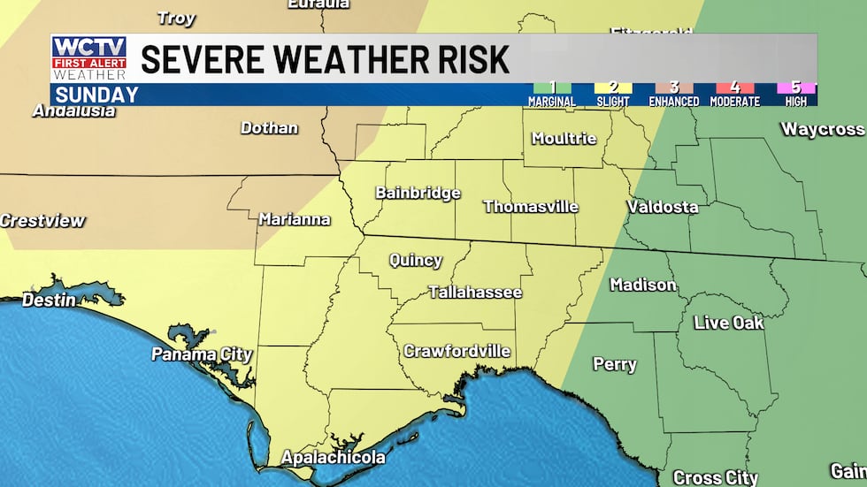
Below is the convective outlook from the Storm Prediction Center. It shows storm categories 1 through 5, based on storm coverage. The higher the risk, the higher the storm coverage.
The level 3, enhanced risk is just to our west. The rest of the area is under a level 2.
 A few strong storms late Sunday and into your Monday morning.(WCTV)Strong storms on Monday
On Monday, we are monitoring the chance for more severe weather as a strong cold front approaches.
I expect a line of storms to develop and approach the area by your Monday morning commute. The strong to severe line will bring a few threats with it.
Scattered damaging wind gusts between 50 and 70 mphA few brief tornadoes, one or two strongQuarter-size hail with some stormsHeavy downpours, rain totals under 0.50″
Storms will start as early as 5 a.m. and should exit the Suwannee River valley by 1 or 2 p.m.
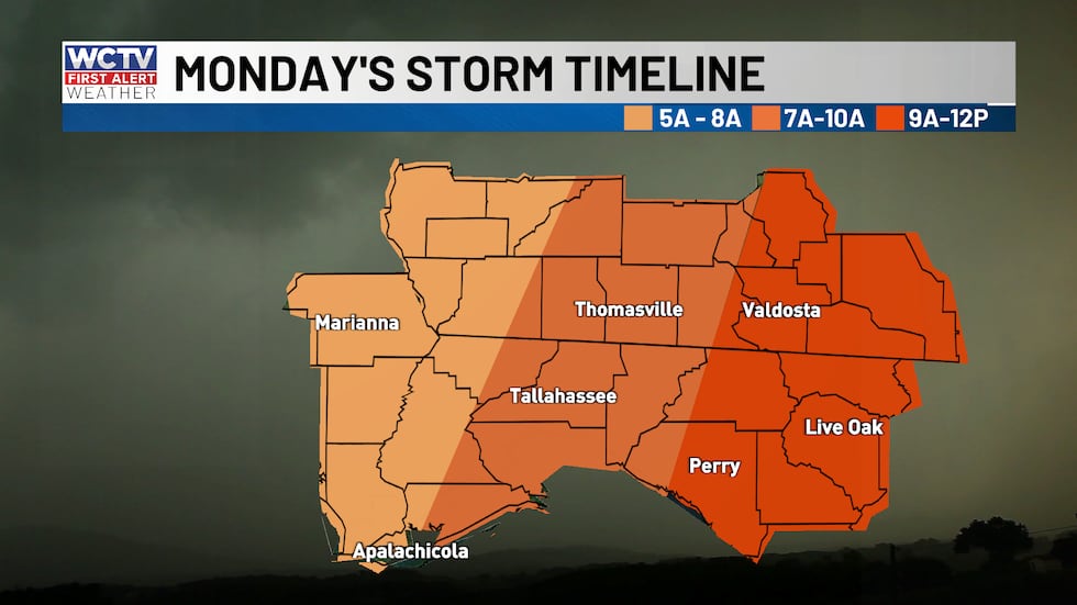 Monday’s storms will impact many during the morning commute. Storms arrive as early as 5 am, lasting through lunchtime.(WCTV)
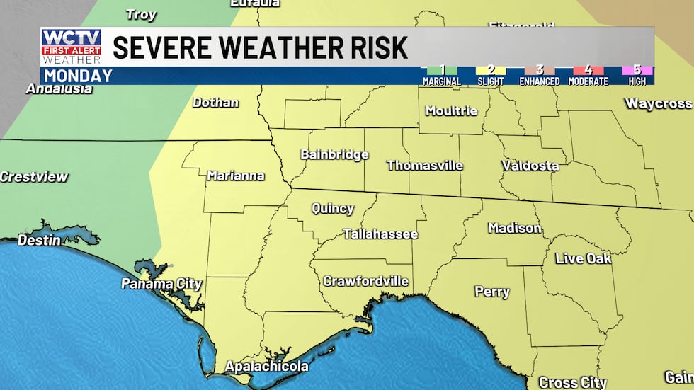
The Storm Prediction Center keeps all of the area under a level 2, slight risk for the majority of the area.
 Storms will be strong on Monday morning.(WCTV)Monday: hazardous marine conditions and a sharp cool-down
Non-thunderstorm winds will ramp up around the front, then turn breezy northwest behind it as much cooler, drier air rushes in.
The cool north wind will drop temperatures from the 70s and 60s on Monday morning to the 50s by the afternoon. It will feel chilly for much of the afternoon as the sun breaks through the clouds.
Hazardous marine and beach conditions on Monday, with advisory-level winds and seas expected and gale-force gusts possible.
Frost/freeze concerns early next week
Colder air settles in on Monday night and Tuesday night. I would expect a late-season frost/freeze for those who have planted early and farmers.
Warmer late next week
Temperatures start to moderate back to our typical March weather in the 70s, with little to no chance of rain.
To stay updated on all the latest forecasts and weather, follow WCTV First Alert Weather on Facebook and X (Twitter).
Click here to see all the latest weather headlines and here to view the First Alert Radar. Receive push alerts and watch the latest forecast anytime on the free WCTV First Alert Weather app. Click here to download it now.
Interested in becoming a WCTV First Alert Weather Watcher? Click here to join the team!
Copyright 2026 WCTV. All rights reserved.