
Central Florida is under an elevated risk for severe weather on Monday as a powerful cold front moves through the region.The National Weather Service has placed all of Central Florida under a Level 2 out of 5 risk for severe storms. That is why WESH 2’s First Warning Weather team has placed Monday as a Severe Weather Warning Day. Storm impactsDamaging winds – MediumHail – MediumTornadoes – LowHeavy rain – Low The threat of strong and severe storms comes in two parts. First, a squall line currently moving over the northern Gulf is anticipated to reach Central Florida this afternoon, which could produce damaging winds. However, ahead of the squall line, we will need to monitor “discrete” cells. WESH 2’s meteorologist Cam Tran explained that these are standalone storms with the potential to produce tornadoes. Tracking the timingCurrent projections show storms moving into Central Florida between about 2 p.m. and 7 p.m., which could impact the afternoon commute.Looking aheadFollowing the passage of this front, temperatures are expected to drop on Tuesday and Wednesday before moderating later in the week.First Warning Weather Stay with WESH 2 online and on-air for the most accurate Central Florida weather forecast.RadarSevere Weather AlertsDownload the WESH 2 News app to get the most up-to-date weather alerts. The First Warning Weather team includes First Warning Chief Meteorologist Tony Mainolfi, Eric Burris, Marquise Meda and Cam Tran. What is a Severe Weather Warning Day?A Severe Weather Warning Day suggests weather conditions that could potentially harm life or property.
ORLANDO, Fla. —
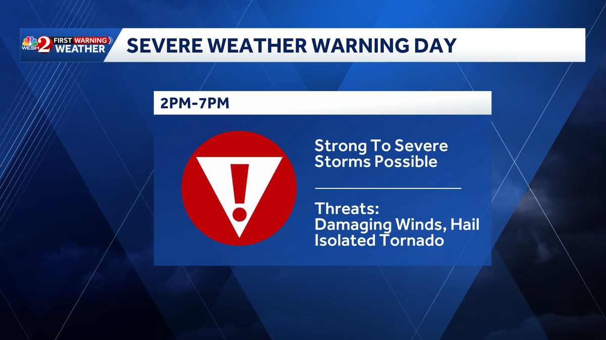
Central Florida is under an elevated risk for severe weather on Monday as a powerful cold front moves through the region.
The National Weather Service has placed all of Central Florida under a Level 2 out of 5 risk for severe storms. That is why WESH 2’s First Warning Weather team has placed Monday as a Severe Weather Warning Day.
Storm impacts
Damaging winds – Medium
Hail – Medium
Tornadoes – Low
Heavy rain – Low
The threat of strong and severe storms comes in two parts.
First, a squall line currently moving over the northern Gulf is anticipated to reach Central Florida this afternoon, which could produce damaging winds.
However, ahead of the squall line, we will need to monitor “discrete” cells.
WESH 2’s meteorologist Cam Tran explained that these are standalone storms with the potential to produce tornadoes.
Tracking the timing
Current projections show storms moving into Central Florida between about 2 p.m. and 7 p.m., which could impact the afternoon commute.
Looking ahead
Following the passage of this front, temperatures are expected to drop on Tuesday and Wednesday before moderating later in the week.
First Warning Weather
Stay with WESH 2 online and on-air for the most accurate Central Florida weather forecast.
Download the WESH 2 News app to get the most up-to-date weather alerts.
The First Warning Weather team includes First Warning Chief Meteorologist Tony Mainolfi, Eric Burris, Marquise Meda and Cam Tran.
What is a Severe Weather Warning Day?
A Severe Weather Warning Day suggests weather conditions that could potentially harm life or property.