
The Brief
Strong winds and severe weather hit Central Florida on Monday, with tornado warnings, hail, and gusts up to 60 mph.
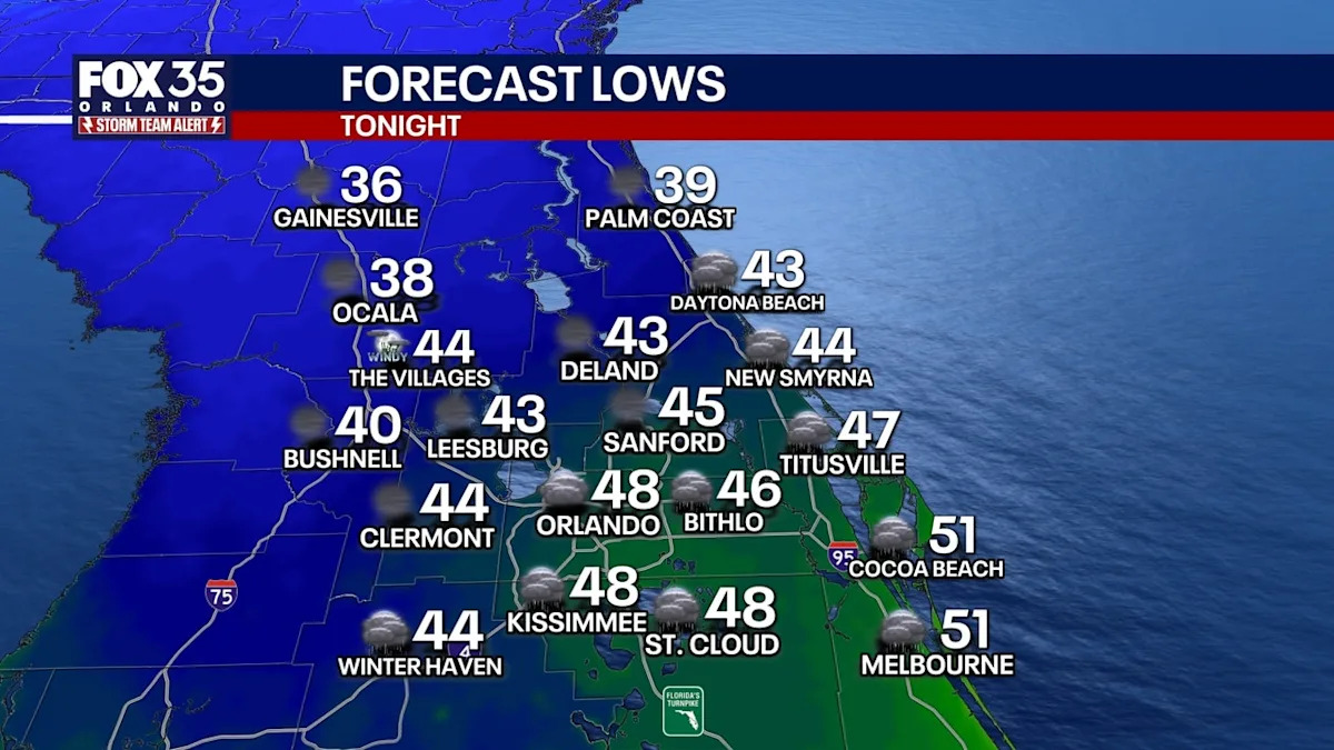
The storm cleared by evening, bringing a cold front that will plunge temperatures into the 30s, 40s, and 50s overnight.
Cooler, dry weather will continue through midweek, with highs gradually warming back to the 70s and seasonable 80s by the weekend.
CENTRAL FLORIDA – Strong winds and severe weather have swept through Central Florida, bringing tornado warnings, hail, and gusts up to 60 mph.
The line of severe weather cleared out of the area by early evening, ushering in colder temperatures.
Temperatures plunge tonight in Orlando, Central Florida
What To Expect
As the severe weather moves out of Orlando and Central Florida, a cold front will drop temperatures tonight into the 30s, 40s, and 50s.
 Tornado watches canceled
Tornado watches that were issued for Alachua, Citrus, Flagler, Levy, Marion, and Sumter counties have been allowed to expire.
Tuesday’s forecast
What To Expect
High pressure at the surface then builds in on Tuesday, which will help usher in much cooler conditions. We’ll still have some spin in the atmosphere aloft which should keep some clouds around too, but it’ll be much drier.
If you’re getting out and about, highs for St. Patrick’s drop back into upper 50s and lower 60s. That’ll be around 15° colder than average for this time of year. Lows overnight will be chilly once again, falling back into the middle to upper 40s around the metro with some upper 30s on the table for our NW locales.
Dry, pleasant, cool week
Looking Ahead
Temperatures stay cooler than average into the middle part of next week with highs Wednesday near 70°.
High pressure continues to build in which will keep things dry and pleasant but still cooler. Highs on Thursday climb back into the lower 70s as we still have that northeast, onshore wind. With that, there’s a slim chance for showers, especially near the coast. Chances in Orlando are only around 10%. Most locales will stay dry.
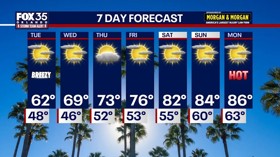
Temperatures will start to climb back closer to average, rising into the lower to middle 70s by later in the workweek with plenty of sunshine on the table.
By this weekend, readings are seasonable, but back above average. Afternoon readings on Saturday are back up into the lower to mid-80s under just a few clouds.
The Source
This story was written with information from the FOX 35 Storm Team