
TALLAHASSEE, Fla. (WCTV) – Sunshine will return on Tuesday, but temperatures stay below average.
Tuesday Forecast 🍀
After showers and thunderstorms on Monday, the forecast is calmer for Tuesday.
We are dry under a mostly sunny sky. Temperatures are much cooler. We only top out in the mid-50s. A breezy wind will stick around. We could see some gusts up to 15 mph at times.
We stay dry under a mostly clear sky for Tuesday night. If you’re planning to celebrate St. Patrick’s Day, be sure to grab the jacket. Low temperatures dip into the low-30s for many locations.
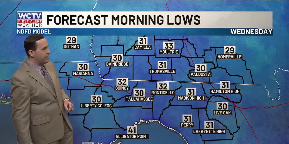
We could see some frost by Wednesday morning. Don’t forget to protect your people, pets and plants.
Slowly Warming Up ⛅
This battle with winter is pretty brief. We are tracking a warming trend for the second half of the week.
Another dry day is on tap for Wednesday. Highs top out in the upper-50s and low-60s under a mix of Sun and clouds. Lows settle in the mid-30s.
Our warming trend will continue on Thursday. Highs climb into the low-70s under some sunshine. Overnight lows fall into the upper-30s.
Ending The Week 🌡️
Friday is looking dry under a mix of Sun and clouds. Temperatures top out in the mid-70s, with lows in the low-50s.
The forecast for the weekend is looking mostly dry and warm. Highs on Saturday and Sunday return to the low-80s under a partly cloudy sky.
A stray shower could be possible on Sunday, but the rain chance is very low at this point.
Low temperatures hover in the mid-50s for the weekend.
To stay updated on all the latest forecasts and weather, follow WCTV First Alert Weather on Facebook and X (Twitter).
Click here to see all the latest weather headlines and here to view the First Alert Radar. Receive push alerts and watch the latest forecast anytime on the free WCTV First Alert Weather app. Click here to download it now.
Interested in becoming a WCTV First Alert Weather Watcher? Click here to join the team!
Copyright 2026 WCTV. All rights reserved.