
Spring Breakers Watching Rain Chances and Rip Current In Central Florida as Temperatures Rise
Spring Breakers Watching Rain Chances and Rip Current In Central Florida as Temperatures Rise
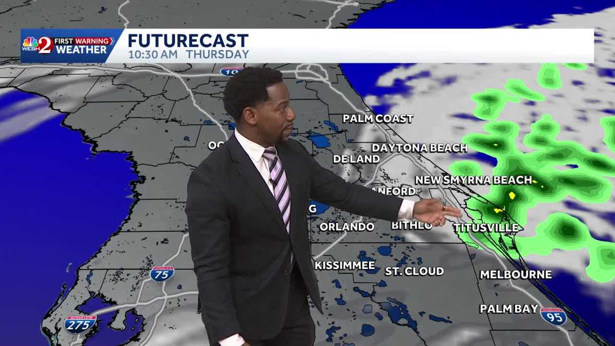
ABOUT THIS IN THE UPCOMING MONTHS. CAN’T WAIT! AWESOME. 747 NOW LET’S GET A CHECK IN FOR CERTIFIED MOST ACCURATE FORECAST. CHECK WITH METEOROLOGIST MARQUISE MEDA. LOOK AT THOSE AFTERNOON TEMPERATURES. MARQUISE. VERY NICE. DEFINITELY A PIVOT DAY HERE FOR US IN CENTRAL FLORIDA. I KNOW WE STARTED OFF THE WORKWEEK WITH THE FREEZING COLD TEMPERATURES IN THE 30S AND 40S, BUT TODAY SOME OF US WILL START TO DEFROST, RIGHT? THAT ALLOWS US TO WORK OUR WAY INTO THE 70S, WITH THE EXCEPTION OF A FEW AREAS ALONG THE COASTLINE, UPPER 60S FROM PALM COAST ALL THE WAY DOWN TO TITUSVILLE. THEN AS YOU HIT BREVARD COUNTY, MELBOURNE, PALM BAY, YOU GUYS WILL HIT 72 DEGREES LATER ON THIS AFTERNOON. BUT AS WE MOVE ACROSS THE REST OF YOUR WORKWEEK AND INTO THE WEEKEND, WE’LL JUST KEEP RAISING THE BAR HIGHER AND HIGHER HERE IN CENTRAL FLORIDA. WHAT STARTED OFF AS A VERY CHILLY START TO YOUR WORKWEEK WILL FINISH IN THE UPPER 70S. IF YOU’RE IN OCALA, THEN ACROSS THE WEEKEND WE’LL TEMPERATURES RETURN TO THE 80S ON SATURDAY AND SUNDAY. JUST A LOT TO LOOK FORWARD TO OUT THE DOOR. RIGHT NOW. THE SKY HAS CLEARED, BUT TEMPERATURES HAVE RISEN TOO MUCH, RIGHT? 47 DEGREES OUT THE DOOR RIGHT NOW. AND THE REASON WHY WE WERE TRENDING COOLER TODAY IS DUE TO THAT NORTHERLY COMPONENT TO YOUR WAYNE, RIGHT? WE PULLED IN THE COOLER AIR FROM THE NORTH, BUT LATER IN THE AFTERNOON WITH CONSISTENT SUNSHINE, WE ARE GOING TO SLOWLY START TO APPROACH THE LOWER 70S HERE IN CENTRAL FLORIDA. SOME OF US STILL IN THE 50S RIGHT NOW, LIKE NEW SMYRNA BEACH, ALSO DAYTONA 40, THOUGH ONCE YOU MOVE ACROSS I-75 FROM OCALA TO THE VILLAGES AND WILDWOOD ALONG THE COAST, WE DO HAVE OUR NEXT FADLEY NINE LAUNCH TO LAUNCH WINDOW HAS BEEN EXTENDED UNTIL 1035. AND WHAT WE’RE WATCHING OUT FOR JUST A COUPLE CUMULUS CLOUDS AND MAYBE EVEN A SLIGHT CHANCE FOR SOME PRECIPITATION. ULTIMATELY, THERE’S AN 80% CHANCE WE WON’T HAVE ANY WEATHER RESTRICTIONS AT THE TIME OF THE LAUNCH. WHEN THEY DO DECIDE TO GO UP. BUT HERE’S WHAT’S WORKING ITS WAY ACROSS THE COASTLINE, RIGHT? WITH THAT NORTHEASTERLY BREEZE, WE DO SEE A SMALL CHANCE FOR A COUPLE COASTAL SHOWERS THIS MORNING IN VOLUSIA COUNTY. THOSE SPILLING OVER INTO BREVARD RIGHT AROUND THE SAME TIME AS THE LAUNCH. SO TIMING IS GOING TO BE EVERYTHING. THIS LAUNCH COMING UP THOUGH, YOU’RE BASICALLY JUST DRY ALL DAY, MOSTLY SUNNY OR PARTLY CLOUDY. SKIES WILL BE PRESENT ACROSS THE REST OF YOUR THURSDAY. IF YOU’RE ALONG THE I FOUR QUARTER. BUT BACK TO THE COAST WE GO LOOKING AT YOUR BEACH AND BOATING FORECAST. SEAS COULD BE ANYWHERE BETWEEN 5 TO 8FT AND WE’RE ALSO WATCHING OUT FOR HIGH RIP CURRENTS. TODAY IN OCALA, THOUGH, TEMPERATURES PEAK IN THE LOW 70S. YOUR FORECAST FOR TONIGHT WILL HAVE YOU DROPPING ANYWHERE BETWEEN 40S 50S AND 60S. SO WIDESPREAD TEMPERATURES, BUT ACROSS YOUR FRIDAY FORECAST FOR MUCH MILDER TEMPERATURES ALL ACROSS THE LAND ARE BACK IN THE 70S, SO LOTS TO LOOK FORWARD TO. THE WEEKEND IS GOING TO BE PRISTINE AS WE STAY SUNNY ON SATURDAY AND SUNDAY. BUT AS WE ENTER THE NEXT WORK WEEK, WE’LL BE WATCHING THIS AREA OF LOW PRESSURE DRAG. A SLOW MOVING COLD FRONT ACROSS CENTRAL FLORIDA THAT WILL INCREASE YOUR CHANCES FOR SHOWERS ON TUESDAY AND WEDNESDAY. BEFORE WE GET THERE AGAIN, LOTS OF SUNSHINE ON THE FIR
Spring Breakers Watching Rain Chances and Rip Current In Central Florida as Temperatures Rise
Spring Breakers Watching Rain Chances and Rip Current In Central Florida as Temperatures Rise

Updated: 8:16 AM EDT Mar 19, 2026
Spring Breakers Watching Rain Chances and Rip Current In Central Florida as Temperatures RiseMild and breezy weather is on tap for us in Central Florida today. Expect to start off your morning with wakeup temps in the forties and fifties today, but conditions will gradually get better. Sunshine is a consistent factor in your workweek forecast and with sunny skies in the picture today highs will hover in the upper sixties and lower seventies this afternoon. With an east coast sea breeze later today, there is a chance for a light shower along the coast line, otherwise just plan on being a bit windy. Gusts can surge up to 25 mph keeping the Rip Current Risk High. Looking ahead, drier and warmer weather builds this weekend with highs climbing back into the 80s this weekend.
Spring Breakers Watching Rain Chances and Rip Current In Central Florida as Temperatures Rise
Mild and breezy weather is on tap for us in Central Florida today. Expect to start off your morning with wakeup temps in the forties and fifties today, but conditions will gradually get better. Sunshine is a consistent factor in your workweek forecast and with sunny skies in the picture today highs will hover in the upper sixties and lower seventies this afternoon. With an east coast sea breeze later today, there is a chance for a light shower along the coast line, otherwise just plan on being a bit windy. Gusts can surge up to 25 mph keeping the Rip Current Risk High. Looking ahead, drier and warmer weather builds this weekend with highs climbing back into the 80s this weekend.