
The Brief
A cold front is set to sweep across Central Florida on Saturday afternoon, bringing an abrupt end to the morning’s sunshine with rapidly increasing clouds and rain.
The primary threat will be damaging wind gusts reaching 40–50 mph, alongside hazardous coastal conditions including 7–12 foot surf and a very high risk of rip currents.
While the weather remains gusty through Monday, a significant warming trend will follow, with temperatures potentially soaring past 90°F by next weekend.
ORLANDO, Fla. – Central Florida residents should prepare for a dramatic shift in weather this weekend as a powerful cold front prepares to sweep across the region, bringing abrupt wind gusts and rough waves along the coast.
While the area will see a calm start to the weekend, by Saturday afternoon, winds will speed up. Here is everything you need to know to stay safe and prepared.
Tonight: The calm before the storm
If you have Friday evening plans, the weather should largely cooperate. After a few lingering spotty showers this evening, the sky will clear out. Expect a pleasant night with overnight lows dipping comfortably into the 60s.
 Saturday: Breezy, strong winds
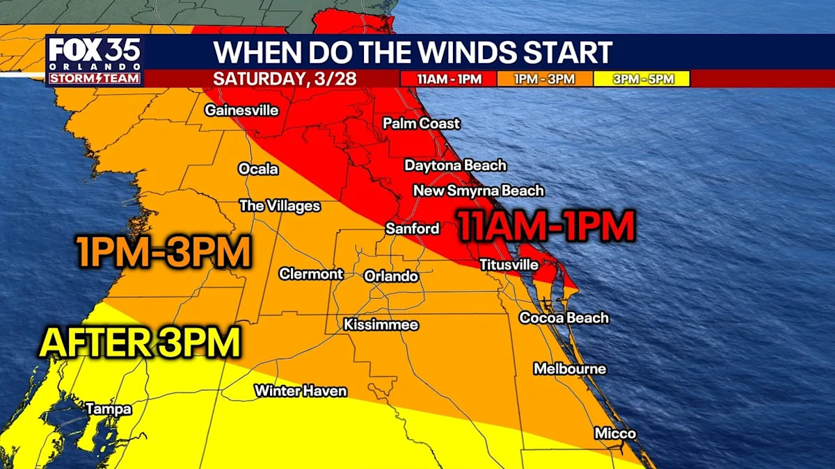
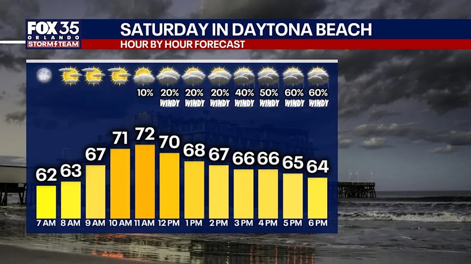
Saturday’s weather is predicted to begin warm and calm. But, a very strong front is timed to move through the region during the afternoon hours.
Arrival: Clouds and wind will first hit the Daytona and Flagler Beach areas, moving southwest toward Central Florida.
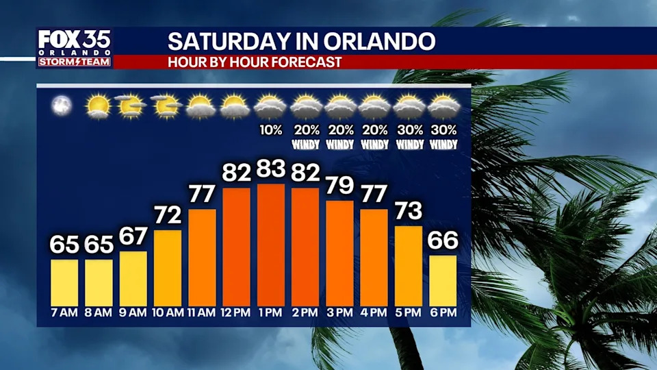
Conditions: Expect conditions to be cloudy and very windy everywhere by late afternoon Saturday.
Wind Threat: This is not your average breeze. Wind gusts are expected to reach 40–50 MPH in some areas. Secure any loose outdoor furniture or decorations before the front arrives.
Coastal Warning: Dangerous surf and erosion
These rough conditions Saturday night and into Sunday are expected to impact beach areas and surf conditions.
A High Surf Advisory is currently in effect for all east coast beaches, with waves predicted to reach heights of seven to 12 feet.
Rip Currents: The risk for life-threatening rip currents will be very high.
Beach Safety: Authorities strongly advise against swimming. Conditions will be “very dangerous” through Sunday.
Erosion: Minor beach erosion is possible, particularly during high tide Saturday evening and Sunday morning.
Boating: A Gale Warning is in effect for offshore waters; mariners should remain in port.
 Looking ahead: Summer heat returns
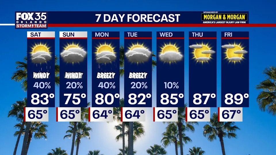
The wind won’t disappear overnight. Sunday and Monday will remain gusty, though slightly calmer, with east winds sustained between 15 to 25 MPH.
While Sunday will see a mix of clouds and peeks of sun, Monday afternoon brings a higher chance of “pop-up” showers and isolated thunderstorms.
As we head into next week, the winds will relax and the clouds will gradually clear.
By the end of next week, Central Florida will return to a mostly sunny pattern with a major warm-up on the horizon. Highs could potentially soar past 90 degrees by next weekend!
The Source
Information in this story was gathered from FOX 35’s Noah Bergren.