
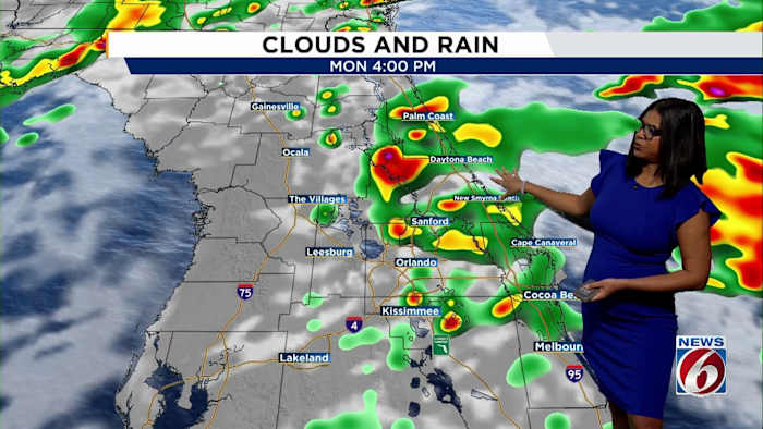
ORLANDO, Fla. – Central Florida is in for a wet start to the week, with rain chances expected to climb Sunday and stick around through Monday.
A stationary front over the region is forecast to lift north as a warm front, bringing steadier showers and a chance for some thunderstorms.
Weather Setup
If you’re heading out this afternoon or Monday, it’s a good idea to keep an umbrella close. Some areas could see a soaking, with forecast rain amounts in the range of 1 to 3 inches for some cities, although the exact spots are still coming into focus.
Daytime highs are expected to stay in the lower to middle 80s, with humidity on the rise until midweek.
[EXCLUSIVE: Become a News 6 Insider (it’s FREE) | PINIT! Share your photos]
Gusty winds and coastal hazards linger
It’s not just the rain — breezy conditions will hang around, especially along the coastline. A high-surf advisory remains in place through Sunday night.
The risk of rip currents remains high through Monday night and there could be some minor beach and dune erosion. Those heading to the shore should exercise extra caution and check local alerts for updates.
Cooler, drier air arriving midweek
For those looking forward to a little less humidity, relief is on the horizon.
A strong cold front is expected to move through the area Wednesday into Thursday, dropping temperatures as Halloween approaches. The seven-day forecast calls for highs in the lower 80s on Tuesday and Wednesday before cooler air drops daytime temperatures into the low 70s by Friday and Saturday.
Next 7 days
Showers and lingering storms are possible early in the week, but the upcoming cold front is likely to usher in drier, more comfortable weather as November begins.
Caught a dramatic rainstorm or choppy surf on camera? Share your weather photos and videos with the News 6 team using our PinIt! feature at ClickOrlando.com/pins/.
[6 things to do: Oct. 25-26]
News 6 Weather Insider
More Stories Like This In Our Email Newsletter
Copyright 2025 by WKMG ClickOrlando – All rights reserved.