
Easter weekend forecast: Toasty temps, showers expected in Central Florida
PLANS HERE, RIGHT? MARQUISE. DEPENDING UPON THE TIMING OF ALL THOSE SHOWERS. THAT’S CORRECT. YOU MAY WANT TO GET THAT. EASTER EGG HUNT OUT OF THE WAY NICE AND EARLY BECAUSE THROUGHOUT THE AFTERNOON WE’LL BE WATCHING A GROWING CHANCE FOR STORMS. TEMPERATURES WILL STAY WARM ALL THROUGHOUT THE WEEKEND, INCLUDING HIGHS IN THE MID 80S TODAY AND SATURDAY, AND MAYBE EVEN JUST A TOUCH WARMER BEFORE THE RAIN BEGINS TO MOVE IN ON SUNDAY. ULTIMATELY, WE’LL WATCH THAT MOISTURE BEGIN TO GROW AS YOUR WEEKEND DOES PROGRESS. RIGHT NOW ACROSS THE COAST, IT IS AMAZING OUTDOORS. 80 DEGREES ON THE DOT HERE IN DAYTONA. WE’LL HAVE TO WATCH OUT FOR THOUGH, IS THIS EAST COAST BREEZE. AND THAT’S GOING TO KEEP THE RIP CURRENT RISK HIGH ALL THROUGHOUT THE REMAINDER OF YOUR WEEKEND COMING UP. TAKE A LOOK AT YOUR TEMPERATURES ACROSS CENTRAL FLORIDA. IT’S A TIGHT KNIT GROUPING RIGHT IN THE UPPER 70S AND LOWER 80S. IN FACT, THE ONLY PLACE I SEE IN THE UPPER 70S IS TITUSVILLE, LOWER 80S EVERYWHERE ELSE. BUT HERE’S A LOOK AT THE WINDS, RIGHT? SOME OF US ARE A LITTLE BIT FASTER THAN OTHERS, LIKE WINTER HAVEN. ALSO, IF YOU’RE IN THE ORLANDO METRO, WINDS ARE ANYWHERE BETWEEN 10 AND 20MPH. WE’LL HAVE THOSE OCCASIONAL GUSTS UPWARDS OF 20 TODAY, BUT HERE’S THAT HIGH RIP CURRENT RISK, RIGHT? SO FROM PALM COAST ALL THE WAY DOWN ACROSS I-95 THROUGH SOUTHERN BREVARD COUNTY, WE DO CARRY THAT HIGH RIP CURRENT RISK ACROSS YOUR WEEKEND INTO SUNDAY. YOUR STRONGEST WINDS, THOSE ARE ALONG THE COASTLINE RIGHT NOW. EDGEWATER IN VOLUSIA COUNTY, 24 MILE PER HOUR CONDITIONS. PORT ORANGE 23. YOU SEE THAT EASTERLY BREEZE THAT’S KEEPING THE WAVE HEIGHTS A LITTLE BIT HIGH. AND OF COURSE, YOUR RIP CURRENT RISK AS WELL WITH THE SYSTEM OF HIGH PRESSURE OFF IN THE ATLANTIC DIRECTING THAT TRAFFIC WITH THAT SOUTH AND EASTERLY WIND. SO IF YOU’RE ANYWHERE WEST OF I-95, THAT’S WHERE THE BETTER CHANCE FOR SHOWERS IS GOING TO LIE. SO STILL A GREAT BEACH DAY FOR US HERE IN CENTRAL FLORIDA. THOSE OF US INLAND, THOUGH, MAY SEE A COUPLE SHOWERS HERE AND THERE. ONCE YOU MOVE PAST THE I-4 CORRIDOR, THE CHANCE WILL GROW IN THE AFTERNOON. HERE’S A LOOK AT THE STATE ROAD 11 IN VOLUSIA COUNTY. FURTHER TOWARDS THE SOUTH ACROSS LAKE MARY. YOU GUYS HAVE SEEN SOME ISOLATED SHOWERS OFF AND ON AGAIN OVER THE COURSE OF THE LAST HALF AN HOUR. LOOKS LIKE WE HAD A STRONG BAND OF RAIN PUSHING ACROSS THE COAST INTO MONTVERDE. THAT’S NOW DISSIPATING OVER LAKE APOPKA THERE. MEADOW WOODS. YOU GUYS HAVE A SHOWER INCHING IN FROM THE EAST, BUT THE FURTHER WEST YOU GO, AS I MENTIONED TODAY, THAT’S WHERE THE BETTER CHANCE FOR RAIN IS GOING TO BE. ACTUALLY, NORTH AND WEST. WE’LL SEE THOSE CHANCES GROW THROUGHOUT THE REMAINDER OF YOUR AFTERNOON. LET’S PRESS PLAY ON FUTURECAST. WE SEE THAT EASTERLY PUSH OF SHOWERS COULD HAVE A SPRINKLE INSIDE THE METRO AT TWO AND 3:00 LEESBURG CLERMONT. YOU GUYS ARE NOW GETTING IN ON THE ACTION PAST THREE. BUT ONCE WE START TO SEE THAT SUN BEGIN TO SET, WE’LL LOSE SOME OF THE HEATING ELEMENTS FROM THE AFTERNOON AND ALSO LOSE THAT CHANCE FOR SHOWERS. SO EXPECT TO BE DRY OVERNIGHT. AFTERNOON HIGHS, AS I MENTIONED, SHOULD BE BACK IN THE MID 80S. FOR THOSE OF US IN THE METRO WARMER, THE FURTHER INLAND YOU GO, 87 FOR YOUR HIGH IN OCALA TODAY. AND THAT’S RIGHT AROUND THE SAME TIME THAT WE’LL SEE THOSE RAIN SHOWERS BEGIN TO POP UP. ULTIMATELY, THAT WILL COOL YOU DOWN AT 3:00, BUT THEN WE’RE BACK IN THE 80S AFTER THAT, DRYING OUT ENTERING THE EVENING. THIS WEEKEND’S HIGH TEMPERATURES SHOW 85 FOR SATURDAY, 86 DEGREES ON SUNDAY. AS WE MOVE ACROSS THE WEEKEND, HERE COMES THE MOISTURE FROM THE SOUTH AND THE EAST AHEAD OF THIS FRONTAL BOUNDARY MOVING IN. WHICH IS WHY ON SUNDAY WE’LL SEE THAT CHANCE FOR SOME SHOWERS MOVING ACROSS THE AFTERNOON AND INTO THE EARLY EVENING. BEST CHANCE DOES EXIST RIGHT AROUND THE I FOUR QUARTER. SO IF YOU’RE IN ORLANDO, PREPARE FOR SOME RAIN ON SUNDAY IN THE AFTERNOON AND THEN IT’S A LATE SEASON COLD FRONT COMING IN, KEEPING YOU A LITTLE BIT COOLER ENTERING THE WORKWEEK 74 DEGREES ON TUESDAY 75, WEDNESDAY, THURSDAY. THAT’S WHEN WE START TO WARM UP UPPER 70S THERE. BUT WE’RE IN THE 80S TODAY, TOMORROW AND SUNDAY WITH THAT CHANCE FOR RAIN ON EASTER. AND THEN WE’LL KEEP THOSE
Easter weekend forecast: Toasty temps, showers expected in Central Florida

Updated: 1:03 PM EDT Apr 3, 2026
Wetter weather begins to take shape ahead of a slow-moving cold front this weekend, which could affect Easter events. Expect to finish the weekend with an increased chance of showers Sunday afternoon and evening as a front moves into the region. The weather looks good for those morning and early afternoon egg hunts, but showers and storms will develop later in the day.Weekend highs will peak in the mid to upper 80s. Looking aheadSoggy conditions linger through the midweek. After the cold front passes, temperatures will drop into the mid- to low 70s by Tuesday and Wednesday.
ORLANDO, Fla. —
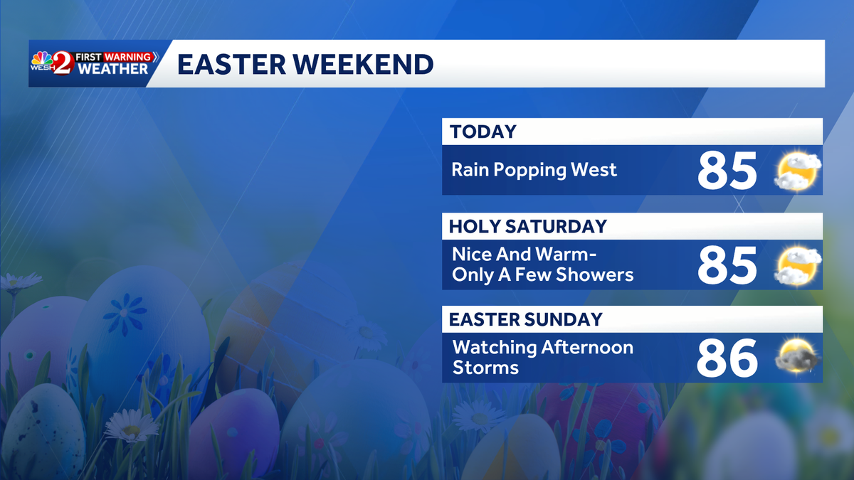
Wetter weather begins to take shape ahead of a slow-moving cold front this weekend, which could affect Easter events.
Expect to finish the weekend with an increased chance of showers Sunday afternoon and evening as a front moves into the region.
This content is imported from Twitter.
You may be able to find the same content in another format, or you may be able to find more information, at their web site.
The weather looks good for those morning and early afternoon egg hunts, but showers and storms will develop later in the day.
Weekend highs will peak in the mid to upper 80s.
Looking ahead
Soggy conditions linger through the midweek.
After the cold front passes, temperatures will drop into the mid- to low 70s by Tuesday and Wednesday.
This content is imported from Twitter.
You may be able to find the same content in another format, or you may be able to find more information, at their web site.
A wet weather pattern is shaping up for next week as several fronts will approach Central #florida and bring rounds of rain that could add up to several inches of much needed rainfall. Here’s a look at the latest rainfall forecasts through Thursday of next week. #weshwx pic.twitter.com/ctbM4yg08h
— Tony Mainolfi (@TMainolfiWESH) April 3, 2026