
Warm and pleasant day. Pick of the weekend across central Florida.
Track the rain chances ahead with meteorologist Victoria Wisniewski
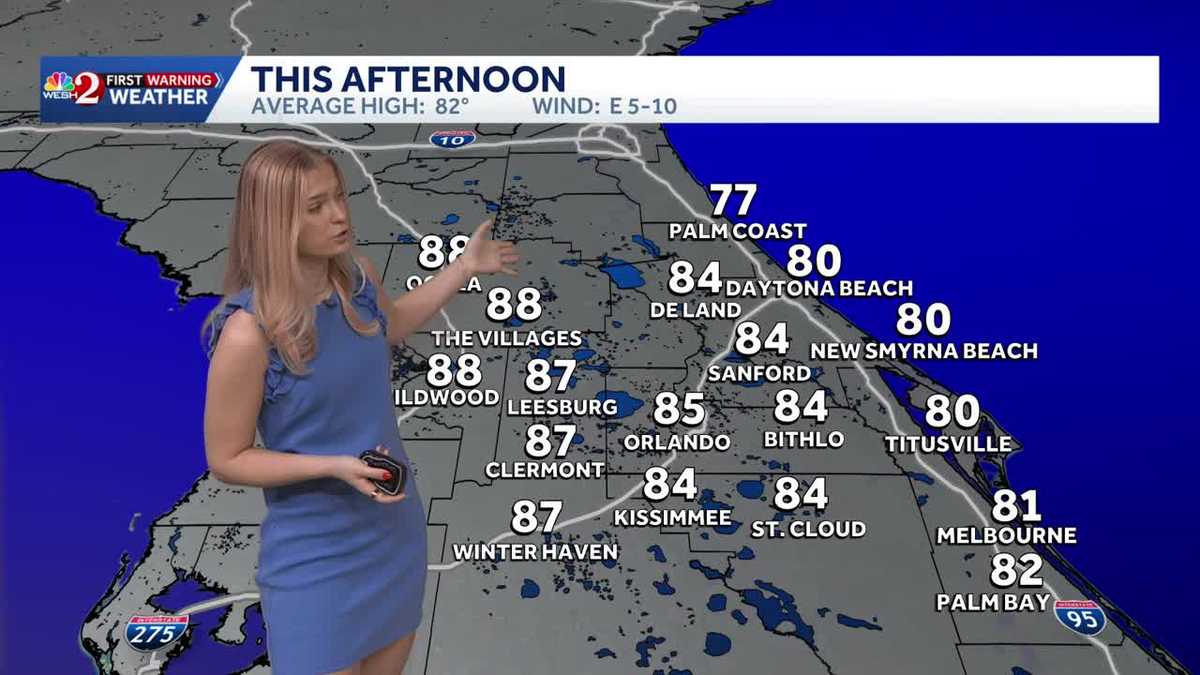
THE LAKES, MAYBE, AND GO FISHING. ABSOLUTELY. BECAUSE, YOU KNOW, WE ARE LOOKING AT THE HIGHER RIP CURRENTS ACROSS CENTRAL FLORIDA. BOB. SO CERTAINLY GOING TO BE A COOL DAY. MAYBE A FISHING DAY, BUT RAIN CHANCES INCREASE AS WE HEAD OVER THE NEXT COUPLE OF DAYS INTO THE LATTER HALF OF YOUR EASTER WEEKEND AND INTO NEXT WEEK. SO TRY TO ENJOY SOME TIME OUTSIDE WHILE YOU CAN. YOU’RE GOING TO NOTICE AS WE HEAD TOWARDS YOUR SUNDAY AND MONDAY, 50 TO 60% CHANCES OF MORE RAIN ACROSSA. WE’RE GOING TO HAVE NOT ONE, BUT TWO COLD FRONTS MOVE THROUGH AS ONE MOVES THROUGH ON SUNDAY. IT’S GOING TO BRING US A CHANCE FOR SOME ISOLATED THUNDERSTORMS. AND THEN AS WE HEAD INTO THE BEGINNING HALF OF YOUR WORKWEEK, IT’S GOING TO REALLY COOL THINGS DOWN WITH SOME MUCH NEEDED RAIN BECAUSE WE ARE IN A PRETTY SIGNIFICANT DROUGHT ACROSS THE STATE. SO FUTURECAST DOES HAVE US IN A BIT OF A WARM WEEKEND WITH ISOLATED SHOWERS FOR TODAY. BUT HERE’S THAT COLD FRONT BEGINNING TO SWEEP DOWN. AND THAT’S GOING TO BRING COOLER TEMPERATURES AS WE HEAD INTO NEXT WEEK. LIVE LOOK RIGHT NOW IN OCALA THIS MORNING SUN WILL BEGIN TO RISE AS WE HEAD CLOSER TO THE 7 A.M. HOUR. 66 DEGREES RIGHT NOW IN THE SANFORD AREA IN ORLANDO AS WELL. AND 73 DOWN TOWARDS THE COASTLINE. FIRST WARNING LIVE RADAR. ALSO NICE AND CLEAR. NO SHOWERS ACROSS THE STATE AS WE HEAD THROUGHOUT THE DAY. YOU CAN EXPECT 70 TURNING INTO 8081 DEGREES. AS WE HEAD TOWARDS THE AFTERNOON. COULD BE A LITTLE BREEZY, BUT OVERALL NO SIGNIFICANT GUSTS AND RATHER WARM, ESPECIALLY IF YOU’RE FURTHER INLAND. 88 DEGREES IN THE VILLAGES AS WELL AS OCALA. 80 IN TITUSVILLE, 80 IN NEW SMYRNA BEACH AND SOME OF THE COASTLINE NEAR THE PALM COAST COULD COME IN THE UPPER 70S. HERE’S A LOOK AT THE CLOUDS AROUND THIS MORNING, AND THEN A COUPLE OF ISOLATED SHOWERS BEGIN TO POP UP RIGHT AROUND THE AFTERNOON. BUT THIS IS A VERY SMALL RAIN CHANCE. THEY BEGIN TO RISE AS WE HEAD TOWARDS THE END OF YOUR EASTER SUNDAY, RIGHT AROUND 2 TO 3 P.M., COULD SEE A COUPLE ISOLATED SHOWERS BOTH INLAND AND THE COASTLINE. AND THEN AS THE COLD FRONT APPROACHES, WE COULD SEE A COUPLE CELLS BEGINNING TO POP AND THOSE COULD HAVE SOME EMBEDDED THUNDERSTORMS WITHIN THEM. BUT AT THIS TIME, NOT LOOKING AT ANYTHING SEVERE, BUT CERTAINLY THE TYPE OF WEATHER, THE ONE YOU’LL WANT TO BRING IT INSIDE, ESPECIALLY FOR YOUR EASTER SUNDAY PLANS. THE MORNING PRETTY NICE. WE’RE GOING TO HAVE A WARM DAY. NOT AS WARM AS YET AS WE HAD TODAY, BUT WE’LL HAVE TO ENJOY WHAT WE CAN BECAUSE. TAKE A LOOK AT BOTH YOUR TUESDAY, WEDNESDAY AND THEN EVEN INTO THURSDAY. WE’LL BE LOOKING AT LOW TO MID 70S. AND ALSO WE’RE GOING TO BE LOOKING AT THAT RAIN BEGINNING TO MOVE IN. TAKING A LOOK AT BOTH THE EUROPEAN AND THE GFS MODEL TO SEE WHO WHAT AREA OF CENTRAL FLORIDA IS GOING TO GET MORE RAIN, WHETHER IT’S GOING TO BE FURTHER INLAND OR ALONG THE COASTLINE. NO MATTER WHAT, WE HAVE SIGNIFICANT CHANCES TO REALLY HELP WITH OUR DROUGHT CONDITIONS COMPARED TO WHERE WE HAVE BEEN. WE ACTUALLY HAD OUR DROUGHT FORECAST AND REPORT EXTENDED. THEREFORE, IT’S SLIGHTLY WORSENED THROUGHOUT CENTRAL FLORIDA. SO A LOOK AT BOTH YOUR INLAND AND COASTAL FORECAST. THE RAIN CHANCES INCREASING AS WE HEAD INTO MONDAY, TUESDAY AND WEDNESDAY. BUT THE GOOD NEWS IS THAT AS WE HEAD CLOSER TO NEXT WEEKEND, WE’LL WARM BAC
Warm and pleasant day. Pick of the weekend across central Florida.
Track the rain chances ahead with meteorologist Victoria Wisniewski

Updated: 7:37 AM EDT Apr 4, 2026
Tracking a beautiful day across Central Florida with highs ranging between 77 and 88 degrees. As clouds move out, sunny skies will prevail. A mostly dry day is forecasted with isolated pop-up showers for some by the afternoon. Easter Sunday brings a beautiful start to church services and Easter egg hunts, but as a cold front enters the region, some showers and storms are forecasted to move into the region; at this time, they are not looking to be severe, though any outdoor plans may need to move indoors.
ORLANDO, Fla. —
Tracking a beautiful day across Central Florida with highs ranging between 77 and 88 degrees. As clouds move out, sunny skies will prevail. A mostly dry day is forecasted with isolated pop-up showers for some by the afternoon.
Easter Sunday brings a beautiful start to church services and Easter egg hunts, but as a cold front enters the region, some showers and storms are forecasted to move into the region; at this time, they are not looking to be severe, though any outdoor plans may need to move indoors.