
TALLAHASSEE, Fla. (WCTV) – Get ready to crank up the A/C. Meteorologist Cameron Aaron is tracking climbing temperatures for the next seven days.
Tonight Through Saturday Night ☀️
Quiet weather will continue across the Big Bend and South Georgia for Friday night. We are dry under a partly cloudy to mostly clear sky. Lows bottom out in the mid-50s.
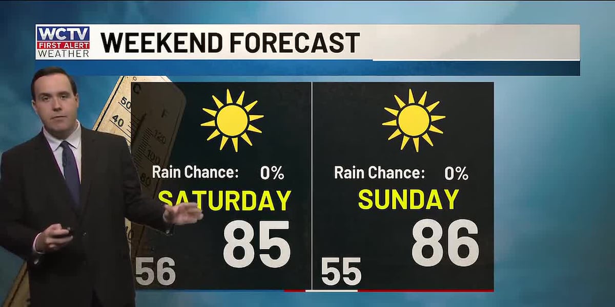
Our warming trend will stick around to start the weekend. Highs on Saturday climb into the mid-80s under a sunny sky.
We are dry and comfortable for Saturday night. Lows settle in the mid-50s under a clear sky.
Taste Of Summer Continues 🌡️
High pressure stays put to end the weekend, so more of the same is on tap.
We are dry and sunny on Sunday. Highs top out in the mid-80s, and lows bottom out in the mid-50s.
Another warm, dry day is on the way for Monday. Temperatures hover in the mid-80s under a mostly sunny sky. Lows fall into the mid-50s.
Extended Forecast 🌵
Our drought will likely worsen over the next week as we are stuck in this warm, dry weather pattern.
Highs on Tuesday and Wednesday climb into the mid-and-upper-80s under plenty of sunshine. Overnight lows dip into the mid-and-upper-50s.
We could see some spots flirt with 90º by next Thursday and Friday. We will keep an eye on that and keep you posted.
To stay updated on all the latest forecasts and weather, follow WCTV First Alert Weather on Facebook and X (Twitter).
Click here to see all the latest weather headlines and here to view the First Alert Radar. Receive push alerts and watch the latest forecast anytime on the free WCTV First Alert Weather app. Click here to download it now.
Interested in becoming a WCTV First Alert Weather Watcher? Click here to join the team!
Copyright 2026 WCTV. All rights reserved.