
TALLAHASSEE, Fla. (WCTV) – Temperatures continue to climb in the coming days, and we could be near the 90º mark to close out the week.
Tonight Through Monday Night
Calm conditions continue across the Big Bend and South Georgia to end the weekend. We are dry under a mostly clear sky. Overnight lows bottom out in the low-to-mid-50s.
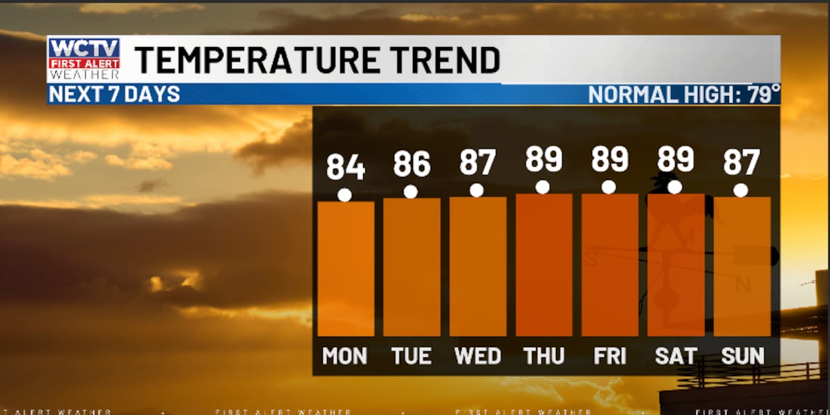
On Monday, we should see a few more high-level clouds. Still, we are dry to start the week and warm. Temperatures reach the low-and-mid-80s.
The forecast is looking quiet and comfortable for Monday night. Lows settle in the low-50s under a mostly clear sky.
Middle Of The Week
If you like the summer heat, you will enjoy the forecast for the middle of the week.
We are dry and mostly sunny for Tuesday, Wednesday and Thursday.
Temperatures soar into the mid-and-upper-80s.
Lows fall into the mid-50s.
Ending The Week
Looking ahead, we could flirt with record high territory to end the week.
Highs on Friday and Saturday climb into the upper-80s and low-90s under a sunny sky.
Overnight lows dip into the mid-and-upper-50s.
To stay updated on all the latest forecasts and weather, follow WCTV First Alert Weather on Facebook and X (Twitter).
Click here to see all the latest weather headlines and here to view the First Alert Radar. Receive push alerts and watch the latest forecast anytime on the free WCTV First Alert Weather app. Click here to download it now.
Interested in becoming a WCTV First Alert Weather Watcher? Click here to join the team!
Copyright 2026 WCTV. All rights reserved.