
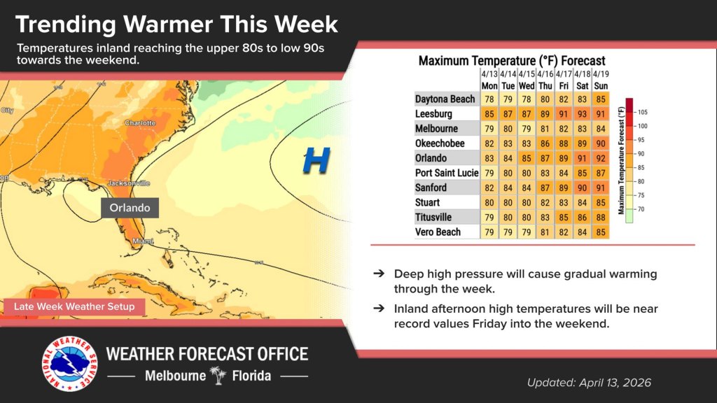
Monday is set to be dry and warm, but still windy across Central Florida, but with temperatures set to climb this week, according to the National Weather Service in Melbourne.
Rough surf and rip current danger also remains at beaches along Florida’s east coast while boating conditions remain hazardous.
“High pressure centered offshore the northeast U.S. coast will extend across north Florida today, allowing the pressure gradient to relax slightly,” according to the NWS forecaster’s discussion. “Breezy onshore winds around 15 mph will still develop this afternoon along the coast, south of the Cape, but
will range from 10-15 mph elsewhere across east central Florida, with gusts up to 20-25 mph.”
Rain chances remain out of the forecast while onshore winds will keep the warmest temperatures inland with highs in the upper 70s and near 70s degrees on the coast, and low 80s in the interior, except in Lake County, which could see mid 80s on Monday.
“Winds then diminish into tonight, but will still be 10-15 mph through this evening at coastal locations south of the Cape. Overnight lows will range from the upper 50s/low 60s across the interior and mid to upper 60s at the coast,” forecasters said.
A ridge of high pressure over the Atlantic is forecast to remain north of the area for much of the week, but then settle farther south across Central Florida later into the week and into the weekend.
“This will allow low level onshore winds to weaken and will combine with ridge aloft to keep a dry weather pattern in place and also continue a gradual warming trend over the next several days,” forecasters said.
Highs will rise into the low to mid 80s by midweek, and then mid to upper 80s across inland areas by Thursday. Come Friday, though, low 90s are forecast across the interior, which will remain into the weekend.
“These temperatures will be near record values for inland sites, and can`t rule out a tied or broken max temp, mainly at Leesburg Friday through Sunday,” forecasters said. “Lows each night will fall into the 60s.”