
TALLAHASSEE, Fla. (WCTV) – Temperatures keep climbing across the Big Bend and South Georgia, and we could flirt with record highs to end the week.
Tonight Through Tuesday Night
Another quiet night is on tap across the Big Bend and South Georgia. We are dry and mostly clear. Lows are comfortable as we settle in the low-to-mid-50s.
Our warming trend will continue for Tuesday. Highs climb into the mid-and-upper-80s under plenty of sunshine.
The forecast is calm, clear and comfortable for Tuesday night. Lows bottom out in the mid-50s.
Middle Of The Week
High pressure stays put for midweek, so this “copy and paste” forecast will continue.
We are dry, mostly sunny and warm on Wednesday and Thursday.
Highs reach the mid-and-upper-80s, while lows dip into the mid-and-upper-50s.
Extended Forecast
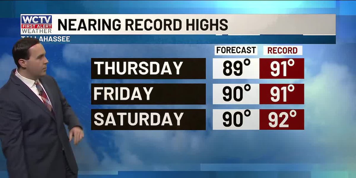
Looking ahead, we are flirting with record highs to end the week.
Temperatures on Friday soar into the upper-80s and low-90s under a sunny sky. The record in Tallahassee is 91º. Overnight lows hover in the mid-50s.
Another dry, hot day is ahead to kick off the weekend. Highs on Saturday top out in the upper-80s and low-90s under a mostly sunny sky. The record in Tallahassee for Saturday is 92º. Lows fall into the upper-50s and low-60s.
On Sunday, we are keeping tabs on a weakening cold front. This weather system may bring an isolated shower or two as we end the weekend. However, at this point, rain chances are pretty unimpressive. We will keep an eye on it and keep you posted in the coming days.
To stay updated on all the latest forecasts and weather, follow WCTV First Alert Weather on Facebook and X (Twitter).
Click here to see all the latest weather headlines and here to view the First Alert Radar. Receive push alerts and watch the latest forecast anytime on the free WCTV First Alert Weather app. Click here to download it now.
Interested in becoming a WCTV First Alert Weather Watcher? Click here to join the team!
Copyright 2026 WCTV. All rights reserved.