
After strong, gusty thunderstorms lashed parts of South Florida with as much as 10 inches of rain in Pompano Beach and significant flash flooding in Boca Raton, a taste of fall weather is on its way.
Areas of Boca Raton, Deerfield Beach and Pompano Beach were under a flash flood warning through Monday morning after as many as 7 inches of rain fell over the areas within an hour or so, according to the National Weather Service Miami.
The flash flood warning in Boca Raton was upgraded to a “considerable” threat of damage after significant flooding on Federal Highway.
Pompano Beach recorded a total of 10 inches between 7 a.m. Sunday to 7 a.m. Monday, NWS Miami data shows. A total of 8.64 inches fell in Deerfield Beach, just under 8 inches in Lighthouse Point and 6.6 inches in Lantana. Boca Raton recorded between 5.4 and 5.61 inches within the 24-hour period.
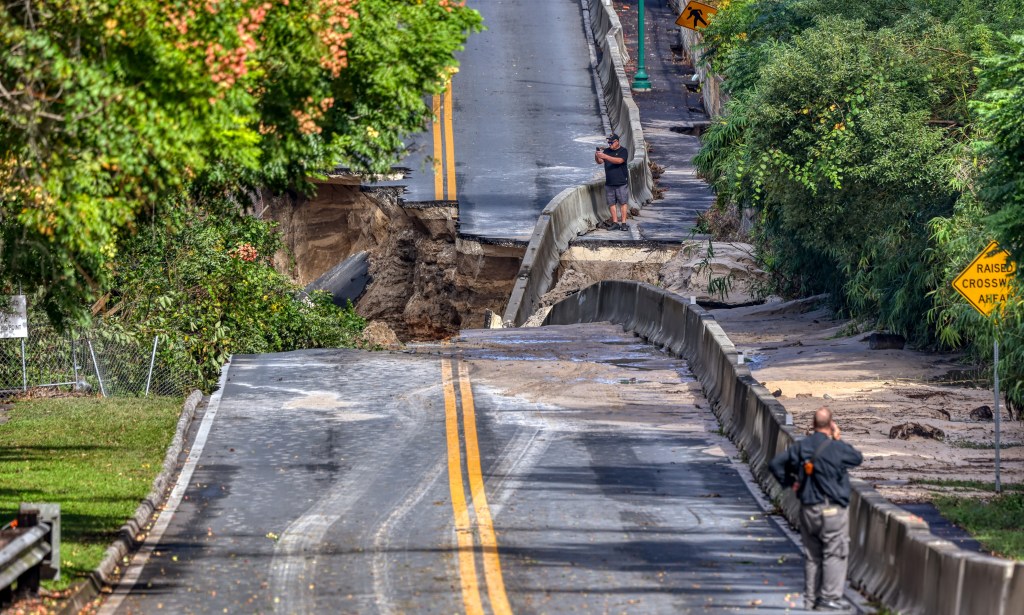
Central Florida’s Lake County took the brunt of the slow-moving storm. Most of Eustis received more than 19 inches of rain; Mount Dora had between 13.5 inches and 17.8 inches of rain. Mount Plymouth recorded just over 10 inches. Tavares had more than 6 inches.
Heavy rains drop more than a foot of rain, wash out roads in Lake County
In Boca Raton, some cars were submerged up to the top of their wheels on State Road A1A and East Palmetto Park Road, while others stalled out at flooded intersections. There were reports of “significant” standing water in the area of Southwest 18th Street and Southwest Eighth Avenue with water nearly intruding into homes, according to NWS Miami.
The storm caused several inches of flooding in the lobby and check-in area of The Boca Raton resort, a spokesperson told the South Florida Sun Sentinel. The area was cleared out to dry, and the hotel is operating normally with no impact to guests. The club’s “normal schedule of offerings” for members will resume Tuesday, the spokesperson said.
Most of the standing water receded Monday morning once the storm-water management system was able to “catch up,” though some areas in the southeastern part of the city were still dealing with standing water as of Monday afternoon, said city spokesperson Anne Marie Connolly. The city had not received reports of any significant damage to homes.
The police department towed as many as 100 cars that had been abandoned across the city Sunday night. Some debris from the storm had blocked drains, and city crews were hustling to clear them throughout the day in the event of any more rain, Connolly said.
There may be more rain in store for South Florida through Monday “before much improved conditions arrive,” the NWS Miami’s forecast said. While most of the storm activity over the West Palm Beach area had cleared by midday, short-term models show showers and thunderstorms could form later in the afternoon and move toward the east coast through early Monday evening. Any more heavy rain could cause some localized flooding.
Starting mid-week, South Florida will get its “first prolonged stretch of fall like weather” as two fronts are forecast to arrive and continue through the weekend, the NWS Miami’s forecast said. Highs are forecast to be in the 70s to 80 with lows in the 50s and 60s.