Nearing record-high temps this weekend across Central Florida
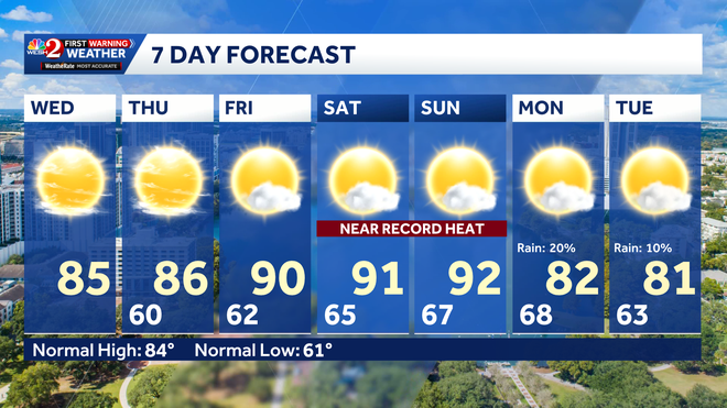
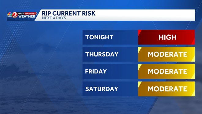
HIGH SCHOOL POOL. YOU CAN FIND MUCH MORE INFORMATION ON HOW YOU CAN HELP@WESH.COM. I KNOW A LOT OF THESE VICTIMS ARE TOURISTS, BUT YOU KNOW, WE HAVE BEEN SAYING FOR A WHILE NOW THAT WE SHOULD NOT BE GETTING IN THE WATER BECAUSE OF THE ROUGH SURF. AND THEN IF YOU ARE GETTING IN THE WATER, MAKE SURE THAT YOU CAN, YOU KNOW, SEE ONE OF THOSE STANDS EXACTLY CLOSE TO A LIFEGUARD, JUST IN CASE YOU NEVER KNOW WHERE RIP CURRENTS COULD REALLY POP UP UNLESS YOU HAVE A TRAINED EYE FOR THEM. SO THE BEST THING YOU CAN DO IS SWIM CLOSE TO SAFETY AND NOT GET TOO FAR INTO THE WATER. IF YOU’RE STEPPING IN THE HIGH RIP CURRENT RISK THAT WE’VE SEEN THROUGHOUT THE WORK WEEK THAT’S BEEN CAUSED BY THE STRONG WINDS SLAMMING AGAINST THE COASTLINE. THANKFULLY, THESE WINDS WILL BE DYING DOWN THE FURTHER INTO THE WORKWEEK WE GO. SO WE’LL ACTUALLY DROP OUT OF A HIGH END DANGEROUS THREAT TONIGHT AND MOVE INTO A MORE MODERATE ONE. AS WE KICK OFF YOUR DAY ON THURSDAY, HERE’S A LOOK AT YOUR WINDS COMING IN FROM THE EAST ACROSS OUR ATLANTIC COASTLINE. NOT AS FAST AS THEY’VE BEEN IN PREVIOUS DAYS THROUGHOUT THE WORKWEEK. RIGHT NOW, ACROSS THE COAST, WE SEE WINDS ANYWHERE BETWEEN 5 AND 15MPH. AND ONCE THESE WINDS REALLY START TO SUBSIDE, WE HAVE CALMER CONDITIONS. NOT ONLY WILL YOUR WAVE HEIGHTS DECREASE, BUT YOUR RIP CURRENT RISK JUST ISN’T GOING TO BE AS DANGEROUS. WHAT WE TYPICALLY SEE HAPPEN WHEN RIP CURRENTS BECOME VERY STRONG IS THAT WE HAVE A SURPLUS OF WATER, GUIDED BY THE WINDS UP TO THE COASTLINE. THAT WATER HAS TO RETREAT, AND THE PRESSURE DIFFERENCE BETWEEN THAT SURPLUS AND THAT EXCESS TRAVELS BETWEEN THESE NARROW SANDBARS, MOST LIKELY. AND THAT’S WHERE YOU START TO SEE THE RIP CURRENT FORMING. WHAT YOU CAN DO IF YOU’RE EVER CAUGHT IN ONE, IS MAKE SURE YOU SWIM PARALLEL TO THE COAST. DON’T TRY TO SWIM AGAINST THE CURRENT JUST BECAUSE IT’S TOO STRONG. EVEN FOR THE MOST EXPERIENCED SWIMMERS. SO ONCE YOU’RE OUT OF IT, JUST MAKE SURE YOU’RE CALLING FOR HELP OR SWIMMING BACK TOWARDS THE SHORELINE. ULTIMATELY, HIGH PRESSURE IS DICTATED. OUR FORECAST SO FAR THROUGHOUT THE WORKWEEK, INCLUDING THOSE STRONG GUSTY WINDS. BUT IT’S LEFT US DRY HERE IN CENTRAL FLORIDA. NO REAL SHOT AT ANY CLOUDS IN THE PICTURE ON VISIBLE SATELLITE, NOR ANY RAIN SHOWERS. MAYBE ONE QUICK HITTING SHOWERS. WHAT WE JUST SAW EAST OF THE FLORIDA TURNPIKE THERE. BUT BACK TO DAYTONA WE GO IN WHICH WE’RE SHOWING MOSTLY SUNNY SKIES BEFORE SUNSET. TEMPERATURES ARE AT 77 DEGREES WITH THAT BREEZE PRETTY SMALL COMING IN FROM THE EAST AND THE SOUTHEAST. THAT SOUTHERLY COMPONENT WARMED UP OUR TEMPERATURES. TODAY. WE’RE BACK IN THE LOW AND MID 80S. ONCE YOU MOVED AWAY FROM THE SHORELINE EFFECT, STILL HOLDING ON TO THE LOWER 80S ACROSS I-4. SO FROM DELAND THROUGH KISSIMMEE TEMPERATURES RIGHT AROUND 82 TO 83 DEGREES HERE JUST PAST 5:00, EVENTUALLY WILL STUMBLE INTO THE LOW 60S IN THE UPPER 50S. UNDERNEATH THESE CLEAR CONDITIONS, WE’RE A LITTLE BIT COOLER AS WE DON’T HAVE THAT BLANKET TRAPPING IN THE HEAT. BLANKET OF CLOUDS IS WHAT I MEAN. SO WE’LL FALL BACK TO THE MID 50S IN OCALA, WAKING UP TO 61 DEGREE TEMPERATURES OUT THE DOOR AT 7:00 IN ORLANDO. BUT WE’RE STILL HEATING UP THROUGHOUT THE REMAINDER OF YOUR WORKWEEK, COURTESY OF THIS BIG OLD H STANDING FOR HIGH PRESSURE. KEEP IT AS NICE AND DRY WITH THE OCCASIONAL COASTAL SHOWER, BUT WE REALLY GOT SOME SERIOUS HEAT COMING OUR WAY ON THE BACK END OF THE WORKWEEK. YOUR HIGHS TOMORROW STILL IN THE 80S, AND THAT’S FROM THE COAST TO OUR INLAND COMMUNITIES. UPPER 80S FOR YOU FINE FOLKS, BUT ACROSS THE TONY YOU’LL MAKE IT BACK INTO THE UPPER 80S THIS WEEKEND. SO GORGEOUS WEEKEND CONDITIONS DO EXIST ACROSS THE BEACHES. WE HAVE A LESS OF A LESSER RIP CURRENT RISK, AND WE ALSO HAVE MUCH WARMER TEMPERATURES. SO BY SATURDAY INLAND, YOU’RE BACK IN THE LOWER 90S, STANFORD 90 ON THE DOT ORLANDO 91 DEGREES TOWARDS THE VILLAGES, 93, ALL COURTESY OF THAT SYSTEM OF HIGH PRESSURE THAT WE WERE TALKING ABOUT IN THOSE EAST AND SOUTHERLY WINDS. HOWEVER, ON SUNDAY WE’LL START TO COOL DOWN AS A COLD FRONT DOES ENTER OUR NECK OF THE WOODS. THAT WILL TAKE YOUR TEMPERATURES FROM NEAR RECORD SETTING POTENTIAL ON SATURDAY AND SUNDAY. IN THE LOW 90S, BACK ABOUT TEN DEGREES AS YOU AS YOU START OFF THE WORK WEEK, EXPECT MORE SUNSHINE IN THE FORECAST ONCE TH
Nearing record-high temps this weekend across Central Florida

Updated: 6:31 PM EDT Apr 15, 2026
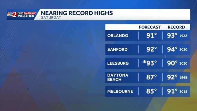
This weekend, multiple areas across Central Florida could see near record-high temperatures that we typically don’t see until late June and early July.WESH 2’s First Warning Meteorologist Marquise Meda said the high pressure over Florida keeps conditions dry and warm today, but through the weekend, these temperatures will get even hotter.Inland highs push into the low 90s.A weak front arrives late Sunday into Monday with a slight chance of showers, breezy conditions and a small cooldown, bringing your highs from near record-setting potential in the 90s this weekend to the lower 80s to start the workweek. Along the coast, a high risk of dangerous rip currents continues; it’s advised to stay out of the water. Looking aheadIf you’re not a big fan of the heat, a cooler front will arrive early Monday morning into Tuesday.The drop in temperatures will come after summer-like heat this weekend.
This weekend, multiple areas across Central Florida could see near record-high temperatures that we typically don’t see until late June and early July.
WESH 2’s First Warning Meteorologist Marquise Meda said the high pressure over Florida keeps conditions dry and warm today, but through the weekend, these temperatures will get even hotter.
Inland highs push into the low 90s.
A weak front arrives late Sunday into Monday with a slight chance of showers, breezy conditions and a small cooldown, bringing your highs from near record-setting potential in the 90s this weekend to the lower 80s to start the workweek.
Along the coast, a high risk of dangerous rip currents continues; it’s advised to stay out of the water.
This content is imported from Twitter.
You may be able to find the same content in another format, or you may be able to find more information, at their web site.
Looking ahead
If you’re not a big fan of the heat, a cooler front will arrive early Monday morning into Tuesday.
The drop in temperatures will come after summer-like heat this weekend.