
Nice, cool morning in Central Florida
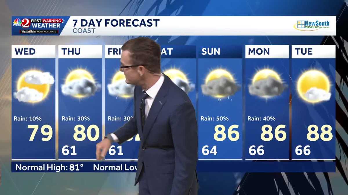
NO, NO, THAT’S A GOOD LESSON. ABSOLUTELY. AND GLAD THAT THE TEAM CAN WALK AWAY FROM THAT. ALL RIGHT. LET’S TALK ABOUT OUR FORECAST. NICE AND COOL OUT THERE THIS MORNING. WE NEED SOME RAIN. YES. THERE’S STILL SEVERAL BURN BANS ACROSS CENTRAL FLORIDA. AND THE REALITY IS THE NEXT COUPLE OF DAYS, WE’LL START TO SEE SOME SHOWERS INTO THE WEEKEND. WILL REALLY DIAL THAT UP. BUT WE’VE GOT MAGIC PLAYOFFS TONIGHT. SO I DO AT LEAST WANT TO MAKE SURE EVERYBODY KNOWS. ALL RIGHT. FOR THOSE THAT MAY BE TRAVELING TO DETROIT, IT WILL BE RIGHT AROUND 68 AT 7:00. MUCH COOLER UP THERE. MEANWHILE, FOR ALL OF OUR PARTIES HERE AROUND CENTRAL FLORIDA WILL BE IN THE MID 70S. CLOUDS OVERHEAD, BUT WE ARE LOOKING GOOD. YOU DID MENTION THE NEED FOR RAIN THOUGH. HIGH PRESSURE SITTING JUST OFF OF OUR SHORELINE HAS BEEN KEEPING US SUPER DRY AND STABLE. BUT OVER THE NEXT FEW DAYS, THIS AREA OF HIGH PRESSURE IS GOING TO SLOWLY DRIFT OFF TO THE SOUTH. GIVE US AN EASTERLY BREEZE, THEN A SOUTHEASTERLY BREEZE, AND THEN A SOUTHERLY BREEZE. IT’S GOING TO EVENTUALLY GRAB MOISTURE AND START PULLING IT INTO OUR DIRECTION. SO FOR TODAY, I’VE GOT A 10% MENTION, LIKE A WHISPER OF A PASSING SPRINKLE TOMORROW, FRIDAY. SAME IDEA. BUT YOU NOTICE SATURDAY, SUNDAY WE REALLY START TO BRING THOSE RAIN CHANCES UP AND WE DO VERY MUCH NEED IT. MELBOURNE IS IN A RAINFALL SURPLUS BECAUSE OF WHAT WAS IT TWO, THREE WEEKS AGO? ALL THAT RAIN THAT WE SAW. BUT NOTICE ORLANDO SANFORD BASICALLY THE REST OF US ARE RUNNING 4 OR 5IN BEHIND WHERE WE SHOULD BE, RIGHT? SO LET’S DO THIS. LET’S DIAL UP THE FUTURECAST MODEL AND LET’S LOOK AHEAD TO SATURDAY, THE 25TH OF APRIL, RIGHT, 9:00 IN THE MORNING. WE’RE GOING TO BE JUST FINE. A COUPLE OF SPRINKLES STARTING UP ALONG THE SHORELINE HERE. 5 P.M. THAT SATURDAY, STARTING THAT SUMMERTIME PATTERN WHERE WE GET A FEW OF THOSE SHOWERS IN THE AFTERNOON. THEN FOR SUNDAY, MORE MOISTURE. THERE’S 1:00 IN THE AFTERNOON, SHOWERS, DIALING UP A WIDER COVERAGE OF SHOWERS AND THUNDERSHOWERS. SO THERE’S YOUR FIRST HINT THAT SUMMER IS HERE. AND IF THAT WASN’T ENOUGH, THE GLOBAL MODELS ARE PAINTING A REALLY HOT FORECAST NEXT WEEK. THE EUROPEAN SAYS MID 90S FOR OUR THURSDAY AND FRIDAY. THAT WOULD BE APRIL 30TH. MAY 1ST. THE GFS LAUGHABLE. I DON’T THINK WE’RE GOING TO HIT 100 DEGREES, BUT THE GFS SAYS HOLD MY LEMONADE. SO EITHER WAY WE’LL WAIT AND SEE HOW THIS PLAYS OUT. NEXT WEEK THOUGH IT LOOKS HOT FOR NOW. LET’S ENJOY IT NOT BEING HOT. IT’S A BEAUTIFUL SHOT IN DOWNTOWN ORLANDO. 61 DEGREES. THE CURRENT TEMPERATURE HERE 56 IN THE VILLAGES, 55 IN DELAND, 52 PALM COAST. NOTHING ON OUR FIRST WARNING. LIVE RADAR FOR TODAY. LITTLE BY LITTLE, THOSE TEMPERATURES CLIMB MID 70S BY 11:00 UPPER 70S 1:00 AND WE’LL HIT 80 DEGREES AS OUR DAYTIME HIGH SEVEN DAY FORECAST SHOWING A 10% CHANCE OF A SPRINKLE IN THERE TODAY. ADDING A FEW ADDITIONAL SHOWERS IN FOR OUR THURSDAY, FRIDAY AND THEN SATURDAY IS THE PRETTIER OF THE WEEKEND DAYS. WE’LL SAY, BECAUSE THE RAIN CHANCES GO UP ON SUNDAY, WE’RE GOING
It’s so nice and cool out—a beautiful morning to start the day.Today, expect increasing clouds with temperatures warming to around 80s, but it will stay nice and dry.A few sprinkles are possible tomorrow and Friday as winds begin shifting, along with gradual warming.By this weekend, highs reach the upper 80s, and storms make a return.First Warning Weather Stay with WESH 2 online and on-air for the most accurate Central Florida weather forecast.RadarSevere Weather AlertsDownload the WESH 2 News app to get the most up-to-date weather alerts. The First Warning Weather team includes First Warning Chief Meteorologist Tony Mainolfi, Eric Burris, Marquise Meda, Cam Tran and Victoria Wisniewski.
ORLANDO, Fla. —
It’s so nice and cool out—a beautiful morning to start the day.
Today, expect increasing clouds with temperatures warming to around 80s, but it will stay nice and dry.
A few sprinkles are possible tomorrow and Friday as winds begin shifting, along with gradual warming.
By this weekend, highs reach the upper 80s, and storms make a return.
First Warning Weather
Stay with WESH 2 online and on-air for the most accurate Central Florida weather forecast.
Download the WESH 2 News app to get the most up-to-date weather alerts.
The First Warning Weather team includes First Warning Chief Meteorologist Tony Mainolfi, Eric Burris, Marquise Meda, Cam Tran and Victoria Wisniewski.