

7:35 AM: After reopening overnight, U.S. Highway 82 in Brantley County is closed again Friday morning. The smoke-filled roadway is closed due to multiple accidents, according to the Glynn County Sheriff’s Office.
“SR520/Hwy 82 between 110 and Browntown Road is closed due to multiple accidents,” a sheriff’s office post states.
Plumes of smoke continue to blanket swaths of Northeast Florida and Southeast Georgia on Friday as crews battle wildfires that have destroyed homes, forced evacuations, and closed schools.
The Highway 82 wildfire in Brantley County hasn’t grown much overnight, but the number of homes and properties destroyed has. As of Friday morning, the number of properties destroyed has increased to at least 87, a couple dozen more than the previous days.
While U.S. Highway 82 has reopened Friday, Brantley County schools remained closed.
More evacuation orders given
The Georgia Emergency Management Agency issued a mandatory evacuation Thursday near Nahunta for the area of Highway 110 from Highway 32 to Lane Cemetery Road to include from Lisa Lane to the Satilla River.
A voluntary evacuation was issued for the area of U.S. 301 from the county line to Rowell Road to the west of Highway 110, north to Highway 32 and east of Highway 110 to the county line.
RELATED: LIST | Shelters open for displaced residents in Brantley County, where to donate
Georgia Governor to survey area Friday
Gov. Brian Kemp is scheduled to survey the fire damage across South Georgia on Friday and meet with local leaders and first responders on the frontlines.
A mandatory burn ban remains in effect for 91 of Georgia’s counties.
In Northeast Florida, fire crews continue to “mop up” the Railroad wildfire in Clay and Putnam counties. That fire on Friday remained at about 4,406 acres and was 65 percent contained. Air quality continues to be an issue.
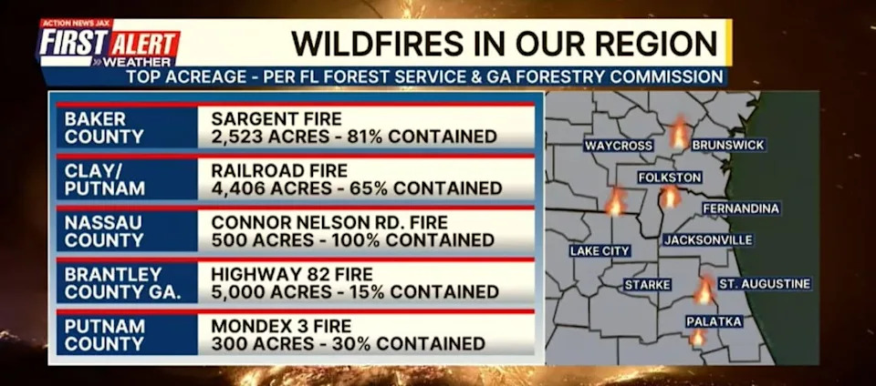
Northeast Florida, Southeast Georgia wildfires, 4/24/2026
Here’s a county-by-county update as firefighters continue to battle wildfires in Northeast Florida and Southeast Georgia:
Northeast FloridaBaker County
Sargent Fire – 2,523 acres, 81% contained
Bradford County
Deden Fire – 180 acres, 50% contained
Columbia County
Gun Range Fire – 129 acres, 50% contained
Clay, Putnam counties
Railroad Fire – 4,406 acres, 65% contained
Putnam County
Pace Court Fire – 343 acres, 85% contained
Mondex 3 Fire – 300 acres, 30% contained
CLICK HEREto view Florida Forest Service’s interactive wildfires map
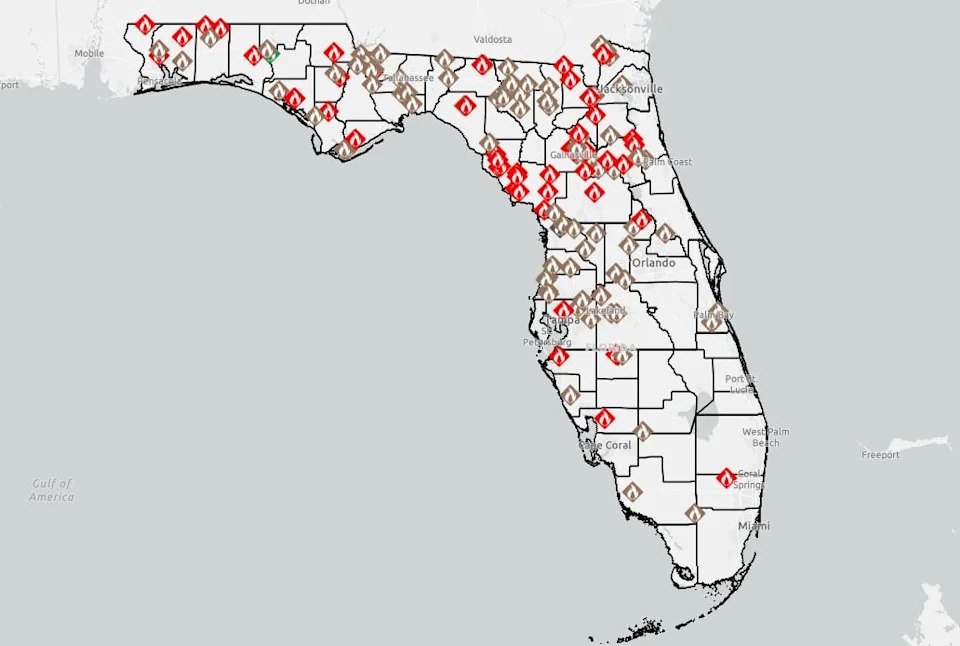
Florida Wildfires Map, 4/24/206
Southeast GeorgiaBrantley County
Highway 82 Fire – Over 5,000 acres, 15% contained
Mandatory Evacuations:
Browntown Road from Hwy 82 to Greenleaf Rd
GA-110 (Yellow Pine Rd) to Thrower Rd
From Thrower Rd to Mossy Oak
Road Closures:
Brantley County Government released the following affected areas and road closures due to active fire conditions and ongoing emergency response:
Highway 82 from Nahunta to Post Road
Highway 110 West – at Highway 32 down to the Camden County line
Highway 259 – from Highway 82 to the Camden County line
Highway 32 – from Highway 110 to Post Road
Clinch County
Pineland Road Fire – 29606 acres, 10% contained.
CLICK HERE to view Georgia Forestry Commission’s interactive wildfires map
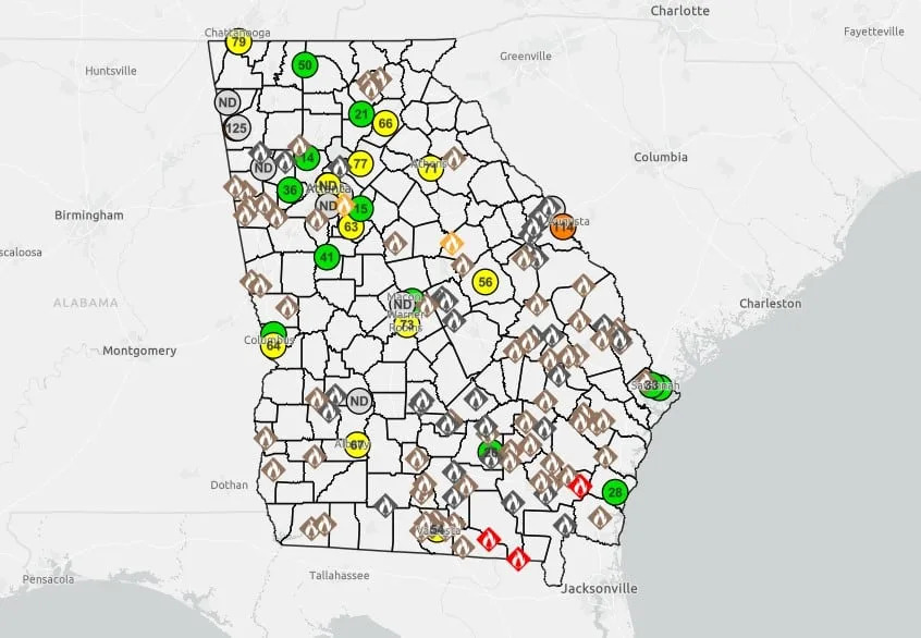
Georgia Fire Map, 4/24/2026
>>> STREAM ACTION NEWS JAX LIVE <<<
[DOWNLOAD: Free Action News Jax app for alerts as news breaks]
[SIGN UP: Action News Jax Daily Headlines Newsletter]
Click here to download the free Action News Jax news and weather apps, click here to download the Action News Jax Now app for your smart TV and click here to stream Action News Jax live.