
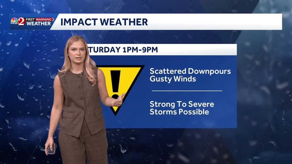
Storms with gusty winds across Central Florida this afternoon
Track what to expect and the temperatures to follow with meteorologist Victoria Wisniewski
IT’S GOING TO BE COOL FOR MANY OF THEM IF YOU ARE HEADING IN THAT DIRECTION. BUT THEN HERE AT HOME, WE ARE GOING TO BE LOOKING AT 8080S AND 90S WITH THE COLD FRONT APPROACHING LATER ON TONIGHT INTO TOMORROW. BUT AHEAD OF THAT, WE ARE GOING TO BE LOOKING FOR SOME SHOWERS TO BEGIN TO POPULATE AND THEN SOME STORMS POSSIBLE LATER THIS AFTERNOON. THAT’S WHY WE HAVE IMPACT WEATHER IN PLACE. STILL. TEMPERATURES ARE GOING TO BE IN THE 80S AND THE 90S. BUT AS THIS COLD FRONT SWEEPS IN FROM THE WEST, IT’S GOING TO BE BRINGING THAT THREAT FOR STRONG TO SEVERE STORMS. AND THEN THE TEMPERATURES FALL. TAKE A LOOK AT OUR CERTIFIED MOST ACCURATE SEVEN DAY FORECAST ACROSS CENTRAL FLORIDA, 77 DEGREES INTO TOMORROW. WE’RE GETTING A LOT MORE DRIER AIR MOVING IN. SO A LOT MORE COMFORTABLE, LESS HUMID FOR YOUR SUNDAY. AND THEN AS WE HEAD TOWARDS THE WEEK AHEAD, WE WILL BEGIN TO WARM UP ONCE AGAIN. 80S QUICKLY TURNING INTO 90S BY WEDNESDAY, THAT NEAR RECORD HEAT IS SOMETHING WE’RE GOING TO BE WATCHING ACROSS CENTRAL FLORIDA. SO TAKING A LOOK AT YOUR SATELLITE AND RADAR, WE HAVE A COUPLE CLOUDS TO OUR NORTH, BUT WE’RE MOSTLY DRY. BUT LOOK AT THE ACTIVE WEATHER MOVING IN FROM THE PANHANDLE. WE ARE LOOKING AT ALL AHEAD OF THIS COLD FRONT. SOME HEAVY DOWNPOURS, CERTAINLY SOME LIGHTNING STRIKES. BUT AT THIS HOUR IT DOESN’T SEEM LIKE WE’RE HAVING ANY SEVERE STORMS, MEANING THOSE WIND GUSTS ANYWHERE CLOSE TO 50 MILE PER HOUR MARK, WHICH IS WHERE A SEVERE THUNDERSTORM WARNING WOULD BE ISSUED. SO I’VE BEEN WATCHING THIS QUITE CLOSELY BECAUSE AS THIS APPROACHES A LITTLE FURTHER SOUTH, THIS WILL DETERMINE WHAT WE COULD SEE HERE AT HOME LATER ON TODAY. SO YOU HAVE TO LOOK AT AREAS FURTHER WEST. AND THEN WE’LL NOTICE THAT AS WE HEAD THROUGHOUT THE AFTERNOON. FOR US, WE’RE LOOKING AT 80S AND 90S. BUT LET’S SEE WHAT WE HAVE IN STORE LATER TODAY. THESE SCATTERED DOWNPOURS WILL BEGIN TO MOVE IN FOR AREAS OF MARION COUNTY TO START, AND THEN SLOWLY MAKE THEIR WAY TOWARDS THE ORLANDO METRO. I’D SAY, BECAUSE WE DON’T HAVE A LOT OF MOISTURE, DEW POINTS IN THE UPPER 60S, MAYBE 70. THAT’S WHY WE HAVE MOSTLY GUSTY WINDS AS THE MAJOR THREAT. WE NEED A LOT MORE MOISTURE TO REALLY CREATE UPLIFT, AND WE DON’T REALLY HAVE THAT WITH THIS SYSTEM BECAUSE IT’S BRINGING IN A LOT DRIER AIR. SO 1 TO 4 P.M. FOR AREAS OF MARION COUNTY AND A LITTLE FURTHER EAST, AND THEN THE ORLANDO METRO BETWEEN 4 TO 7 P.M. THIS IS WHERE IF YOU ARE GOING TO BE OUTSIDE, YOU SHOULD KEEP YOUR EYES TO THE SKY FOR SOME CHANGING CONDITIONS. IF YOU HEAR THUNDER, YOU GO INDOORS. AS I MENTIONED, DAMAGING WINDS WILL BE THE MEDIUM THREAT. HAIL AND TORNADOES. IT’S STILL A VERY LOW THREAT. IT’S ON THE TABLE. IT’S SOMETHING THAT WE ARE GOING TO BE WATCHING, ESPECIALLY IF YOU ARE ALONG THE COASTLINE. BUT OTHERWISE THAT IS GOING TO BE OUR MAJOR CONCERN AS WE HEAD THROUGHOUT THIS AFTERNOON. LET’S TRACK IT HOUR BY HOUR. YOU SEE, SHOWERS AND STORMS ARE GOING TO BE NORTH OF THE PALM COAST, KIND OF OUT OF OUR VIEWING AREA, BUT NEAR JACKSONVILLE. AND THEN AS WE HEAD THROUGHOUT THE NEXT COUPLE HOURS, MANY OF THEM KIND OF NEAR THE PALM COAST COULD SEE SOME HEAVIER DOWNPOURS. BUT I’D SAY WHAT I’VE NOTICED OVER THE PAST 12 HOURS IS THAT A LOT OF OUR MODEL RUNS ARE HAVING A LOT OF THOSE STORMS ACTUALLY CLOSER TO TAMPA BAY. SO THAT IS SOMETHING TO KEEP IN MIND THAT A LOT OF THEM ARE MOVING A LITTLE FURTHER SOUTH AND WEST, SO WE’RE STILL GOING TO HAVE A THREAT FOR THE HEAVIER DOWNPOURS AND THE WIND GUSTS, AS WELL AS A LOW THREAT FOR HAIL AND POTENTIALLY TORNADO. BUT OTHERWISE, WE’RE JUST
Storms with gusty winds across Central Florida this afternoon
Track what to expect and the temperatures to follow with meteorologist Victoria Wisniewski

Updated: 7:36 AM EDT May 2, 2026
This afternoon, a cold front will approach Central Florida from the west, bringing a threat of stronger storms by the afternoon.Beginning at 1 PM, the First Weather Warning Team will be issuing an Impact Weather Day.Track when your area may see storms. Scattered heavy downpours will move in from the West, bringing gusty winds and a threat of thunder and lightning. A wind advisory is in place from 10 AM this morning for Volusia, Lake, Orange, Seminole, and Brevard Counties until 6 PM this evening for gusts up to 40 mph ahead of the cold front.Our team will be watching for a low threat of hail and tornadoes as the cold front approaches. By Sunday Tempertures will drop with a couple of shower chances forecasted for the morning before drier conditions move in for the afternoon. Stay with WESH 2 online and on-air for the most accurate Central Florida weather forecast.RadarSevere Weather AlertsDownload the WESH 2 News app to get the most up-to-date weather alerts. The First Warning Weather team includes First Warning Chief Meteorologist Tony Mainolfi, Eric Burris, Marquise Meda, Cam Tran and Victoria Wisniewski.What is Impact Weather?Impact Weather suggests weather conditions could be disruptive or a nuisance for travel and day-to-day activities.
ORLANDO, Fla. —
This afternoon, a cold front will approach Central Florida from the west, bringing a threat of stronger storms by the afternoon.
Beginning at 1 PM, the First Weather Warning Team will be issuing an Impact Weather Day.
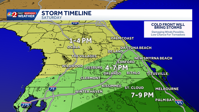
Track when your area may see storms.
Hearst Owned
Strom Timeline 5/2
Scattered heavy downpours will move in from the West, bringing gusty winds and a threat of thunder and lightning.
A wind advisory is in place from 10 AM this morning for Volusia, Lake, Orange, Seminole, and Brevard Counties until 6 PM this evening for gusts up to 40 mph ahead of the cold front.
Our team will be watching for a low threat of hail and tornadoes as the cold front approaches.
By Sunday Tempertures will drop with a couple of shower chances forecasted for the morning before drier conditions move in for the afternoon.
Stay with WESH 2 online and on-air for the most accurate Central Florida weather forecast.
Download the WESH 2 News app to get the most up-to-date weather alerts.
The First Warning Weather team includes First Warning Chief Meteorologist Tony Mainolfi, Eric Burris, Marquise Meda, Cam Tran and Victoria Wisniewski.
What is Impact Weather?
Impact Weather suggests weather conditions could be disruptive or a nuisance for travel and day-to-day activities.