
STORMS BEGINNING TO POPULATE AFTER 1 P.M. TODAY. SO YOU’RE GOING TO SEE ALREADY REALLY WARM CONDITIONS, BUT THIS COMES TO AN END AFTER THE SHOWERS AND STORMS MOVE THROUGH, ALL DUE TO A COLD FRONT. WE’RE LOOKING AT A HIGH OF 90 DEGREES IN CLERMONT TODAY, 92 IN KISSIMMEE, 89 IN THE VILLAGES. AND HERE’S THE SET UP. YOU’RE GOING TO SEE THE COLD FRONT MOVES IN FROM THE NORTH AND THE WEST AND THE TWO AIR MASSES. THIS WARM, MOIST AIR IS GOING TO GET CLASHED BY THIS COLDER AND DRIER AIR. SO THE ATMOSPHERE GETS MAD AT ITSELF AND IT DOES CREATE SOME SHOWERS AND STORMS. BUT AFTER THIS, BY TOMORROW WE’RE LOOKING AT UPPER 70S ACROSS CENTRAL FLORIDA. YOU CAN TAKE A LOOK AT YOUR CERTIFIED MOST ACCURATE FORECAST WHERE 77 BY TOMORROW, MONDAY 82 DEGREES AND THEN 88 BY TUESDAY. SO WE SEE THE WARMTH ONCE AGAIN WITH THE RAIN CHANCES INCREASING BY THE MIDDLE TO END OF THE WEEK. HERE’S SATELLITE AND RADAR. AT THIS HOUR, WE CAN SEE THAT WE HAVE MOSTLY CLOUDY SKIES UP NORTH, BUT THE SHOWERS AND STORMS ARE MOVING THROUGH AREAS OF THE PANHANDLE AS THEY DO. I’M WATCHING THEM QUITE CLOSELY AND TO SEE IF THERE’S SEVERE THUNDERSTORM WARNINGS OR WHAT THOSE WIND GUSTS ARE LOOKING LIKE, BECAUSE AS THIS CONTINUES TO SHIFT FURTHER SOUTH, WE’RE GOING TO SEE THAT IMPACT HERE AT HOME. AND THAT’S CERTAINLY GOING TO DETERMINE WHAT TYPE OF AFTERNOON WE ARE GOING TO BE HAVING. WE’LL HAVE THE SCATTERED DOWNPOURS, BUT GUSTY WINDS IS GOING TO BE THE PRIMARY THREAT. THERE IS A SMALL THREAT FOR SOME HAIL OR POTENTIALLY A SPIN UP, BUT FOR THE MOST PART, I’M JUST GOING TO BE LOOKING AT THE GUSTY WINDS. 1 TO 4 P.M. IS WHEN YOU MAY SEE SOME OF THE CONDITIONS CHANGE. IF YOU’RE NEAR OCALA OR THE VILLAGES UP NEAR THE PALM COAST AS WELL, 4 TO 7 P.M. FOR AREAS OF THE ORLANDO METRO MOVING INTO NEW SMYRNA BEACH AND DAYTONA, AND THEN ANYONE ELSE FURTHER SOUTH COULD SEE THOSE THREATS LATER ON TODAY. SO SOME OF THESE NEW MODEL RUNS ARE BEGINNING TO SHOW SOME MORE WIDESPREAD RAIN. BUT YOU CAN SEE ALREADY BY THROUGHOUT THE AFTERNOON INTO THE EVENING HOW WE REMAIN QUITE SHOWERY. BUT THOSE HEAVIER DOWNPOURS ARE WHAT IS GOING TO BE BRINGING US THE THREAT FOR SOME EMBEDDED THUNDERSTORMS, AS WELL AS SOME OF THE GUSTY WINDS. I THINK THE BIGGEST THREAT FOR MORE OF THOSE SEVERE STORMS IS ACTUALLY TOWARDS THE WEST COAST. SO TO AREAS OF GREATER ORLANDO ARE NOT GOING TO BE LOOKING AT MORE OF THAT SEVERE THREAT, BUT STILL SOME STRONGER STORMS POSSIBLE THROUGH DELAND MOVING INTO DAYTONA BEACH AND NEW SMYRNA BEACH LATER ON THIS EVENING. BUT WE REALLY NEED THE WARMING OF THE DAY TO REALLY CREATE MORE UPLIFT. AND WE’RE NOT REALLY GOING TO HAVE THAT BASED ON THE TIMING HERE. AND THEN AS WE HEAD TOWARDS YOUR SUNDAY, WE ARE CERTAINLY GOING TO COOL DOWN AND DRY OUT. YOU CAN SEE SOME OF THE SEVERE STORM POTENTIAL AREAS OF THE WEST COAST ARE GOING TO BE THE BIGGEST CONCERN. SO BUT FOR US IN ORLANDO, YOU COULD SEE SOME OF THOSE COLORS OF THE GREEN AND THE YELLOW THAT COULD INDICATE A LITTLE BIT MORE ENERGY FOR US HERE AT HOME. THE DEW POINTS, SEE HOW THEY CHANGE OVER THE NEXT COUPLE HOURS. YOU’RE LOOKING AT 60S AND 70S THROUGHOUT THE MORNING. BUT THEN AS WE HEAD TOWARDS TOMORROW, A MUCH DRIER ATMOSPHERE, THERE’S THAT COLD FRONT SWEEPING THROUGH AND WE’RE LOOKING AT DEW POINTS IN THE 50S, SO MUCH DRIER AND MORE COMFORTABLE AIR. BUT THAT ALSO MEANS WE HAVE TO WATCH OUR FIRE WEATHER BECAUSE WE ARE LOOKING AT THIS HOUR AT A GRAY AND A RED FLAG WARNING CLOSER TO MELBOURNE. SO WATCHING YOUR SEVEN DAY FORECAST ACROSS CENTRAL FLORIDA, MU
Tornado watch issued for Central Florida as front moves in on Saturday afternoon

Updated: 11:56 AM EDT May 2, 2026
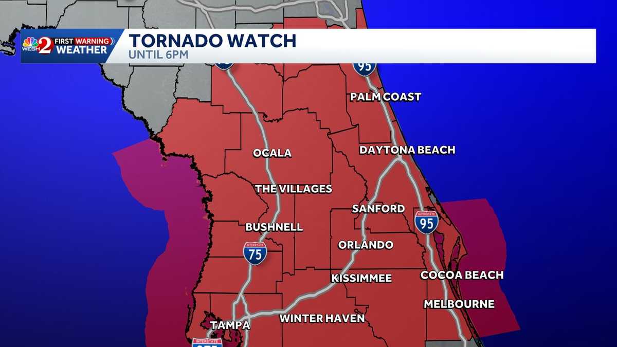
A tornado watch has been issued for nearly all of Central Florida until 6 p.m. Saturday as a front moves in, bringing a threat for severe weather. Beginning at 1 p.m., the First Weather Warning Team is calling for Impact Weather.RadarSevere Weather AlertsScattered heavy downpours will move in from the West, bringing gusty winds and a threat of thunder and lightning.A wind advisory is in place from 10 a.m. this morning for Volusia, Lake, Orange, Seminole, and Brevard Counties until 6 p.m. for gusts up to 40 mph ahead of the cold front.Active alertsTornado watch issued for Brevard, Lake, Orange, Osceola, Seminole and Volusia counties. Wind advisory issued for Volusia, Lake, Seminole, Orange, Osceola and Brevard counties.Our team will be watching for a low threat of hail and tornadoes as the cold front approaches.Looking aheadBy Sunday, temperatures will drop with a couple of shower chances forecasted for the morning before drier conditions move in for the afternoon.Stay with WESH 2 online and on-air for the most accurate Central Florida weather forecast.RadarSevere Weather AlertsDownload the WESH 2 News app to get the most up-to-date weather alerts.The First Warning Weather team includes First Warning Chief Meteorologist Tony Mainolfi, Eric Burris, Marquise Meda, Cam Tran and Victoria Wisniewski.What is Impact Weather?Impact Weather suggests weather conditions could be disruptive or a nuisance for travel and day-to-day activities.
A tornado watch has been issued for Central Florida until 6 p.m. Saturday as a front moves in, bringing a threat for severe weather.
This content is imported from Twitter.
You may be able to find the same content in another format, or you may be able to find more information, at their web site.
Beginning at 1 p.m., the First Weather Warning Team is calling for Impact Weather.
Scattered heavy downpours will move in from the West, bringing gusty winds and a threat of thunder and lightning.
A wind advisory is in place from 10 a.m. this morning for Volusia, Lake, Orange, Seminole, and Brevard Counties until 6 p.m. for gusts up to 40 mph ahead of the cold front.
Our team will be watching for a low threat of hail and tornadoes as the cold front approaches.
This content is imported from Twitter.
You may be able to find the same content in another format, or you may be able to find more information, at their web site.
Here’s a look at our Satellite loop to help you plan your morning. Showers and storms are expected to move in by early afternoon and s few may become strong to severe! Stay with @WESH for updates. #weshwx pic.twitter.com/6bdXRxk8Sn
— Tony Mainolfi (@TMainolfiWESH) May 2, 2026
Looking ahead
By Sunday, temperatures will drop with a couple of shower chances forecasted for the morning before drier conditions move in for the afternoon.
This content is imported from Twitter.
You may be able to find the same content in another format, or you may be able to find more information, at their web site.
Stay with WESH 2 online and on-air for the most accurate Central Florida weather forecast.
Download the WESH 2 News app to get the most up-to-date weather alerts.
The First Warning Weather team includes First Warning Chief Meteorologist Tony Mainolfi, Eric Burris, Marquise Meda, Cam Tran and Victoria Wisniewski.
What is Impact Weather?
Impact Weather suggests weather conditions could be disruptive or a nuisance for travel and day-to-day activities.