
Severe Thunderstorm Threat Dying Down In Central Florida Ahead of Weekend Temperature Dip – May 2nd
Severe Thunderstorm Threat Dying Down In Central Florida Ahead of Weekend Temperature Dip
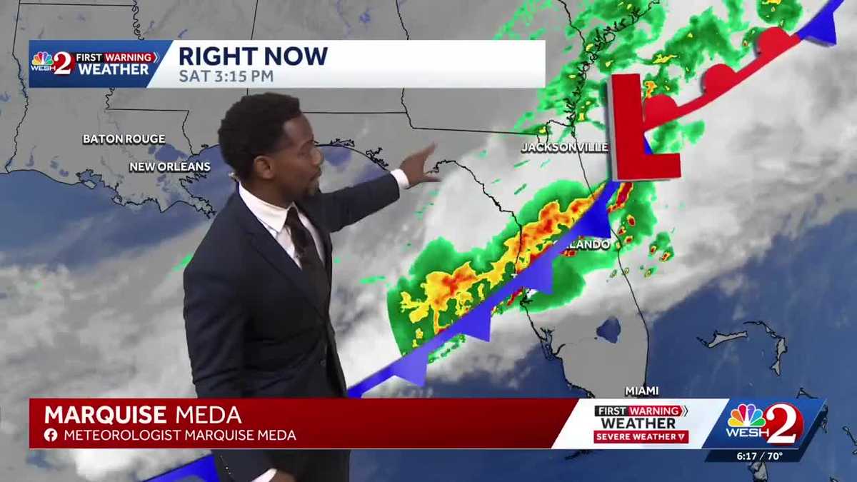
SIGNIFICANTLY HERE IN CENTRAL FLORIDA, RIGHT? ONE MOMENT WE WERE SAYING HELLO TO THE 90S TO KICK OFF YOUR WEEKEND. THE NEXT, WE’RE BACK IN THE 70S ACROSS BREVARD COUNTY, 76 IN MELBOURNE, 76 IN PALM BAY AND BACK IN THE CITY. BEAUTIFUL. YOU’RE BARELY HANGING ON TO THE LOWER 70S 70 ON THE DOT AS WE STILL HAVE SOME LIGHT SHOWERS MOVING ABOUT THE AREA. HERE’S THE COLD FRONT. THE CULPRIT BEHIND TODAY’S WEATHER CHANGES AND EVENTS IN THAT SEVERE WEATHER THREAT. THINK ABOUT IT LIKE THIS. WE HAVE THIS COOLER, DRIER AIR BEHIND THIS FRONTAL BOUNDARY. WARM AND UNSTABLE AIR AHEAD OF IT. AND THAT’S WHERE THE INSTABILITY IS THE GREATEST. RIGHT ALONG THAT FRONT WHERE WE’RE STILL SHOWING A FEW SHOWERS. BUT WE DID SEE THAT SEVERE WEATHER EARLIER THIS AFTERNOON, ABOUT 5 TO 6 SEVERE THUNDERSTORM WARNINGS. THOSE HAVE NOW EXPIRED. BUT WHAT WE’RE LEFT WITH LIGHTER SHOWERS IN SCOTTSMOOR, TITUSVILLE. BACK TOWARDS THE WEST WE GO INTO DISNEY KISSIMMEE, POINCIANA, WHERE WE SEE THIS LIGHTER SHADE OF GREEN. JUST A FEW MORE DROPLETS FALLING, AND ACROSS LAKE WALES, FROSTPROOF LIGHT TO MODERATE RAIN, BUT OVERALL, MOST OF THE SHOWERS ARE NOW EAST OF THE I-4 CORRIDOR, CONTINUING TO HEAD THAT DIRECTION TOWARDS I-95. AND WE DO HAVE THIS STRONG WESTERLY PUSH OF OUR WINDS. EARLIER IN THE DAY, WE DID HAVE A BIT OF A SEA BREEZE INTERACTION COMING IN FROM THE EAST, WHERE THE EAST WINDS MET THE WEST. THAT CONVERGENCE LED TO A FEW STRONGER SHOWERS AND STORMS CELLS. ULTIMATELY, THOUGH, WE HAVE THIS STRONG WESTERLY FLOW ANYWHERE BETWEEN 10 AND 15MPH ACROSS ORANGE AND INTO BREVARD COUNTY. SOME OF OUR FASTEST WINDS, THOUGH, THOSE WERE BACK TOWARDS THE WEST. OCALA 45 MILE PER HOUR GUSTS TODAY, LEESBURG 51. SO THESE WINDS WERE HOWLING. THE RAINFALL WASN’T TOO BIG OF A FACTOR. IN FACT, BUSH NOW 1.24IN. MERRITT ISLAND JUST ABOUT THREE QUARTERS OF AN INCH. WILDWOOD ABOVE HALF AN INCH. JUST LIKE SALT SPRINGS, 0.62. AND WE COULD SQUEEZE OUT ANOTHER QUARTER OF AN INCH BEFORE TONIGHT IS SAID AND DONE. BUT I DO BELIEVE THE STRONGEST RAIN, THE STRONGEST WINDS AND THE STRONGEST SEVERE WEATHER THREAT IS NOW PAST US. SO SIX, 7:00 WATCHING THE SHOWERS PUSH TOWARDS THE EAST BY 930. NOT MUCH RAIN LEFT, RIGHT. A COUPLE ISOLATED SHOWERS HERE AND THERE AS WE HEAD INTO OVERNIGHT HOURS. JUST CLOUDY SKIES A
Severe Thunderstorm Threat Dying Down In Central Florida Ahead of Weekend Temperature Dip – May 2nd
Severe Thunderstorm Threat Dying Down In Central Florida Ahead of Weekend Temperature Dip

Updated: 7:45 PM EDT May 2, 2026
Severe Thunderstorm Threat Dying Down In Central Florida Ahead of Weekend Temperature DipA Severe Weather Warning Day has been issued today. A Marginal to Slight Risk for severe storms place through 8:00 especially near and north of I-4. The main threats are damaging wind gusts, with a small chance for hail or even a brief tornado. A Tornado Watch has been issued for all of Central Florida and is active through 6:00 pm as a cold front descends from the north. Ahead of the storms, it’ll be hot and windy highs in the low to mid 90s with gusts up to 35 miles per hour. Heat will add to the instability ahead of the front, but our dry conditions will also create dangerous fire weather where lightning strikes can prove to be an ignition source. Showers and storms will move out before the midnight hour, leaving much cooler and drier air behind the front. Expect to drop back into the seventies by Sunday.
Severe Thunderstorm Threat Dying Down In Central Florida Ahead of Weekend Temperature Dip
A Severe Weather Warning Day has been issued today. A Marginal to Slight Risk for severe storms place through 8:00 especially near and north of I-4. The main threats are damaging wind gusts, with a small chance for hail or even a brief tornado. A Tornado Watch has been issued for all of Central Florida and is active through 6:00 pm as a cold front descends from the north. Ahead of the storms, it’ll be hot and windy highs in the low to mid 90s with gusts up to 35 miles per hour. Heat will add to the instability ahead of the front, but our dry conditions will also create dangerous fire weather where lightning strikes can prove to be an ignition source. Showers and storms will move out before the midnight hour, leaving much cooler and drier air behind the front. Expect to drop back into the seventies by Sunday.